
Lindgren Brothers (Jolly Elmer Lindgren, Oscar Sims Lindgren, Hjalmer Lindgren, Ott Sims Lindgren)

Lindgren Brothers (1928 – 1971) was a Spokane, Washington, based printer known for issuing humorous souvenir auto decals, maps, and posters. The firm was founded as a sign-painting company by Hjalmer 'Jolly' Lindgren (1895 - September 1952) and his brother Oscar 'Ott' Lindgren (1893 - 1967), born in Wisconsin to Swedish immigrants. Neither brother had middle names when they went off to fight in World War I (1914 - 1818), but as the government required it, they adopted Jolly and Ott, which stuck with them for life. Jolly was in charge of the art department and Ott was in charge of the business aspects of the firm. The company began as printers and sign makers, and also became innovators in silkscreen printing, and as the Great Depression deepened, Jolly began producing 'hysterical maps'. He declared at the time, ‘What this country needs now is something to put a smile on people's faces.' The maps are graphically interesting and intended, as the titles suggest, to amuse. The brothers focused on producing maps of popular tourist attractions, and the great national parks of the West were an obvious choice. They produced maps of Yellowstone, the Grand Canyon, Glacier, Zion, Bryce Canyon and others through the early 1940s. Following a hiatus during World War II (1939 - 1945), the company began producing car decals, some of which were simplified versions of the ‘hysterical maps'. The company sold more than ten million decals in a good year. In 1949, the company was renamed the Lindgren-Turner Company when their traveling salesman, Theodore 'Ted' Turner, Jr. (1902 - 1989), who had been with the firm since 1930, became a partner. Jolly died unexpectedly at 57 while visiting his daughter in Boise, Idaho. The firm continued under his brother, Oscar. William Shigeo Terao (1915 - 1990), who was hired after World War II by the Lindgrens and eventually became the firm's art director, created two more hysterical maps following Jolly's death. The company's last great success, after the decal market had become too competitive, was a sign that read 'No Trespassing, Survivors will be Prosecuted'. The signs became a massive success, eventually being sold in every Woolworth's department store nationwide - all 2,228 locations. Ott died in 1967 at the age of 74, leaving Turner as the last member of the original team. He, in turn, sold the firm to the Emblem Manufacturing Company based in Los Angeles, in February 1971 and he and his wife moved to New Mexico three years later to be closer to their daughter. Turner wrote a history of the Lindgren-Turner Company during his retirement and died at the age of 87 in 1989.
AKA: Jolly Elmer Lindgren, Oscar Sims Lindgren, Hjalmer Lindgren, Ott Sims Lindgren
Rare First Edition of the Pioneering Lindgren Yellowstone Map.
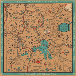
A Hysterical Map of the Yellowstone Park with Apologies to the Park. Smilage Guaranteed. / The Famous Hysterical Map of Yellowstone Park Including a Few Minor? Changes.
$1,750.00
Acquire
- Digital Map Information
- Suitable for large format printing
- Full resolution TIFF file
- ICC color profile embedded
- Delivered instantly via download link
This is the extremely rare 1934 first edition pictorial map of Yellowstone Park, 'hatched and scratched' by the American printer and humorist Jolly Lindgren. It is one of only a handful of silkscreen-printed maps produced by the Lindgren Brothers early in their career. (more details)
Yellowstone National Park during the New Deal.
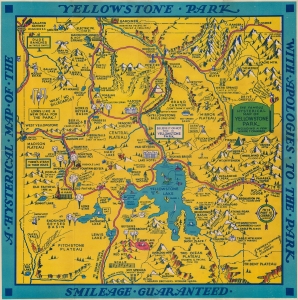
A Hysterical Map of the Yellowstone Park with Apologies to the Park. Smilage Guaranteed. / The Famous Hysterical Map of Yellowstone Park Including a few minor ? Changes.
$500.00
Acquire
A cheerful 1936 pictorial map of Yellowstone Park, 'hatched and scratched' by the American printer and humorist Jolly Lindgren. The map depicts the whole of Yellowstone Park with a richly humorous array of vignettes and annotations. Major roadways through the park are marked in red with important locations, topography, and more illustrated pictorially. As the title suggests, 'smilage' is guaranteed to the viewer. Some of the amusing annotations include:
- Brimstone Basin (Hell for Certain)
- Gibbons Falls (Are ya Hurt?)
- Grand Canyon (Don't Think it Ain't)
- Wahb Springs (Just a Little Cold in the Head)
Silkscreened Example: Yellowstone Revisited.
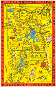
A Hysterical Map of Yellowstone Park and the Jackson Hole Country. Slightly Cockeyed.
$1,200.00
Acquire
- Digital Map Information
- Suitable for large format printing
- File Size: 14.26 MB
- File Type: ZIP / TIFF
- ICC color profile embedded
- Delivered instantly via download link
This is a hilarious c. 1936 Jolly Lindgren pictorial map of Yellowstone National Park and Jackson Hole, Wyoming - here in a hand-silkscreened exemplar. This is the second of two Yellowstone maps issued in 1936; this one is expanded to include Jackson Hole. It also stands out for its deviant red border instead of Lindgren's standard blue. Unlike most Lindgren Brothers maps, this map has no copyright or imprint. (more details)
In the year the Grand Coulee Dam started producing electricity.
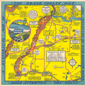
A Hysterical Map of the Grand Coulee Dam all Connected up with Running Water Added Attraction, Dry Falls
$650.00
Acquire
- Digital Map Information
- Suitable for large format printing
- DPI: 600
- File Size: 14.43 MB
- File Type: ZIP / TIFF
- ICC color profile embedded
- Delivered instantly via download link
This is Joly Lindgren's 1940 pictorial map of the Grand Coulee Dam on the Columbia River, Washington. This is a scarce silkscreened example. It is the second of Lindgren's two maps of the Grand Coulee Dam. That Lindgren reissued this map in 1940 is no mistake, for it was that year when the dam began operating and generating electricity, transforming not only the physical landscape but also the economic outlook of the entire region. Lindgren hints at this optimism in his humor, 'To the south lies the Columbia Basin 1,200,000 thirsty acres with a faith in the future'. (more details)
Tahoe!
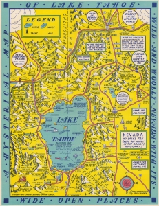
A Hysterical Map of Lake Tahoe Wild and Wooly Nevada with its Wide Open Places.
$650.00
Acquire
- Digital Map Information
- Suitable for large format printing
- Full resolution TIFF file
- ICC color profile embedded
- Delivered instantly via download link
This is a 1947 Jolly Lindgren 'hysterical' map of Lake Tahoe. Created in Lindgren's iconic style, Lake Tahoe take center stage, with surrounding camps, lakes, mountains, ski resorts, and towns. The California-Nevada state line is prominently illustrated, and Lindgren emphasizes legal gambling in Nevada and its illegality in California. Reno is situated in the upper right, with its slogan 'the biggest little city in the world'. Gambling phrases echo out from Reno, which is also identified as an 'un-hitching post'. Virginia City, the site of the famous Comstock Lode appears south of Reno. Signs in Nevada proclaim, 'legal gambling' and a 'huge' sign declares 'Nevada: No Sales Tax'. Lodges, an occasional tavern, and mountain peaks are identified throughout both California and Nevada. Truckee, California, the 'famed winter sports center', appears in the upper left. (more details)
Grand Teton.
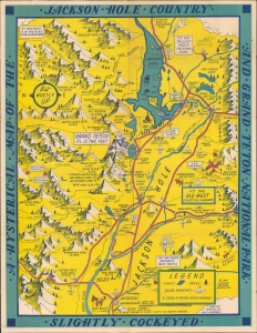
A Hysterical Map of the Jackson Hole Country and Grand Teton National Park. Slightly Cockeyed.
$750.00
Acquire
- Digital Map Information
- Suitable for large format printing
- File Size: 21.34 MB
- File Type: ZIP / TIFF
- ICC color profile embedded
- Delivered instantly via download link
A blend of the comic and the practical, this is a 1948 Jolly Lindgren larger format pictorial map of Jackson Hole and Grand Teton, Wyoming. This is one of the rarer of Lindgren's 'Hysterical' map series, which gained popularity against the grim backdrop of first the Great Depression and World War II. (more details)
The 'lowest' place.
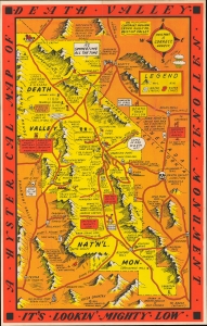
A Hysterical Map of Death Valley National Monument Its Lookin' Mighty Low.
$950.00
Acquire
- Digital Map Information
- Suitable for large format printing
- File Size: 17.84 MB
- File Type: ZIP / TIFF
- ICC color profile embedded
- Delivered instantly via download link
A blend of the comic and the practical, this is a 1950 Jolly Lindgren larger format pictorial map of Death Valley National Monument. This is one of the rarer of Lindgren's 'Hysterical' map series, which gained popularity against the grim backdrop of first the Great Depression and World War II. (more details)