
Lindgren Brothers (sold) (Jolly Elmer Lindgren, Oscar Sims Lindgren, Hjalmer Lindgren, Ott Sims Lindgren)

Lindgren Brothers (1928 – 1971) was a Spokane, Washington, based printer known for issuing humorous souvenir auto decals, maps, and posters. The firm was founded as a sign-painting company by Hjalmer 'Jolly' Lindgren (1895 - September 1952) and his brother Oscar 'Ott' Lindgren (1893 - 1967), born in Wisconsin to Swedish immigrants. Neither brother had middle names when they went off to fight in World War I (1914 - 1818), but as the government required it, they adopted Jolly and Ott, which stuck with them for life. Jolly was in charge of the art department and Ott was in charge of the business aspects of the firm. The company began as printers and sign makers, and also became innovators in silkscreen printing, and as the Great Depression deepened, Jolly began producing 'hysterical maps'. He declared at the time, ‘What this country needs now is something to put a smile on people's faces.' The maps are graphically interesting and intended, as the titles suggest, to amuse. The brothers focused on producing maps of popular tourist attractions, and the great national parks of the West were an obvious choice. They produced maps of Yellowstone, the Grand Canyon, Glacier, Zion, Bryce Canyon and others through the early 1940s. Following a hiatus during World War II (1939 - 1945), the company began producing car decals, some of which were simplified versions of the ‘hysterical maps'. The company sold more than ten million decals in a good year. In 1949, the company was renamed the Lindgren-Turner Company when their traveling salesman, Theodore 'Ted' Turner, Jr. (1902 - 1989), who had been with the firm since 1930, became a partner. Jolly died unexpectedly at 57 while visiting his daughter in Boise, Idaho. The firm continued under his brother, Oscar. William Shigeo Terao (1915 - 1990), who was hired after World War II by the Lindgrens and eventually became the firm's art director, created two more hysterical maps following Jolly's death. The company's last great success, after the decal market had become too competitive, was a sign that read 'No Trespassing, Survivors will be Prosecuted'. The signs became a massive success, eventually being sold in every Woolworth's department store nationwide - all 2,228 locations. Ott died in 1967 at the age of 74, leaving Turner as the last member of the original team. He, in turn, sold the firm to the Emblem Manufacturing Company based in Los Angeles, in February 1971 and he and his wife moved to New Mexico three years later to be closer to their daughter. Turner wrote a history of the Lindgren-Turner Company during his retirement and died at the age of 87 in 1989.
AKA: Jolly Elmer Lindgren, Oscar Sims Lindgren, Hjalmer Lindgren, Ott Sims Lindgren
Pioneering silkscreening - one of Lindgren's earliest works.
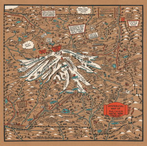
Hysterical Map of Rainier Nat'n'l Park More or Less Cockeyed.
sold
- Digital Map Information
- Suitable for large format printing
- File Size: 18.92 MB
- File Type: ZIP / TIFF
- ICC color profile embedded
- Delivered instantly via download link
This is the only known surviving example of one of the Lindgren Brother's earliest 'Hysterical Maps', their 1933 pictorial map of Mount Rainier. It is one of just 9 maps issued by the Lindgren Brothers using an ad hoc silkscreen technique they pioneered in-house - all of the Lindgren Brothers' rare screen-printed maps are striking for their rich color. After their first map in 1932, the Lindgren Brothers produced just four more maps in 1933, all copyrighted by local advertising agent Lee R. Double, likely a client of their sign-painting business. (more details)
Wonderfully humorous and graphic map of Yellowstone National Park drawn during the New Deal.
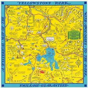
A Hysterical Map of the Yellowstone Park with Apologies to the Park. Smilage Guaranteed. / The Famous Hysterical Map of Yellowstone Park Including a few minor ? Changes.
sold
- Digital Map Information
- Suitable for large format printing
- File Size: 15.51 MB
- File Type: ZIP / TIFF
- ICC color profile embedded
- Delivered instantly via download link
A cheerful 1936 pictorial map of Yellowstone Park, 'hatched and scratched' by the American printer and humorist Jolly Lindgren. The map depicts the whole of Yellowstone Park with a richly humorous array of vignettes and annotations. Major roadways through the park are marked in red with important locations, topography, and more illustrated pictorially. As the title suggests, 'smilage' is guaranteed to the viewer. Some of the amusing annotations include:
- Brimstone Basin (Hell for Certain)
- Gibbons Falls (Are ya Hurt?)
- Grand Canyon (Don't Think it Ain't)
- Wahb Springs (Just a Little Cold in the Head)
Yellowstone National Park during the New Deal.
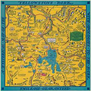
A Hysterical Map of the Yellowstone Park with Apologies to the Park. Smilage Guaranteed. / The Famous Hysterical Map of Yellowstone Park Including a few minor ? Changes.
sold
- Digital Map Information
- Suitable for large format printing
- Full resolution TIFF file
- ICC color profile embedded
- Delivered instantly via download link
A cheerful 1936 pictorial map of Yellowstone Park, 'hatched and scratched' by the American printer and humorist Jolly Lindgren. The map depicts the whole of Yellowstone Park with a richly humorous array of vignettes and annotations. Major roadways through the park are marked in red with important locations, topography, and more illustrated pictorially. As the title suggests, 'smilage' is guaranteed to the viewer. Some of the amusing annotations include:
- Brimstone Basin (Hell for Certain)
- Gibbons Falls (Are ya Hurt?)
- Grand Canyon (Don't Think it Ain't)
- Wahb Springs (Just a Little Cold in the Head)
Wonderfully humorous and graphic map of Yellowstone Park drawn during the New Deal.
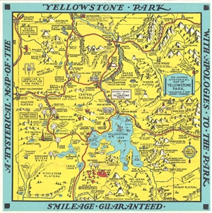
A Hysterical Map of the Yellowstone Park with Apologies to the Park. Smilage Guaranteed. / The Famous Hysterical Map of Yellowstone Park Including a few minor ? Changes.
sold
- Digital Map Information
- Suitable for large format printing
- File Size: 6.75 MB
- File Type: ZIP / TIFF
- ICC color profile embedded
- Delivered instantly via download link
A cheerful 1936 pictorial map of Yellowstone Park, 'hatched and scratched' by the American printer and humorist Jolly Elmer Lindgren. The map depicts the whole of Yellowstone Park with a richly humorous array of vignettes and annotations. Major roadways through the park are marked in red with important locations, topography, and more illustrated pictorially. As the title suggests, 'smilage' is guaranteed to the viewer. Some of the amusing annotations include:
- Brimstone Basin (Hell for Certain)
- Gibbons Falls (Are ya Hurt?)
- Grand Canyon (Don't Think it Ain't)
- Wahb Springs (Just a Little Cold in the Head)
A comical pictorial map of Yellowstone National Park and Jackson Hole.
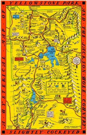
A Hysterical Map of Yellowstone Park and the Jackson Hole Country. Slightly Cockeyed.
sold
- Digital Map Information
- Suitable for large format printing
- File Size: 13.25 MB
- File Type: ZIP / TIFF
- ICC color profile embedded
- Delivered instantly via download link
This is a hilarious c. 1936 Jolly Lindgren pictorial map of Yellowstone National Park and Jackson Hole, Wyoming. The map depicts the region from Idaho to the Absaroka Range and from Montana to Jackson. Major roadways are marked in red with important locations, topography, and more illustrated pictorially. Humorous asides and illustrations are present throughout. Some of the amusing annotations include:
It has been argued that the bright colors and humorous nature of the map are intended to inspire good spirits against the backdrop of national social and economic depression - but such might be said of the entire genre of cartoon pictorial maps which were experiencing a golden age at this time. (more details)
- Old Faithful singing 'I'm Forever Blowing Bubbles'
- Fountain Paint Pot (It Stinks Too)
- Yellowstone Falls (And How)
- Wahb Springs (Just a Little Cold in the Head)
- Hamburgers (on the Hoof)
- Hot Springs (Mustn't Touch)
It has been argued that the bright colors and humorous nature of the map are intended to inspire good spirits against the backdrop of national social and economic depression - but such might be said of the entire genre of cartoon pictorial maps which were experiencing a golden age at this time. (more details)
Early Silkscreened Example: Yellowstone National Park during the New Deal.
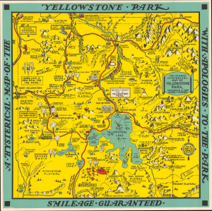
A Hysterical Map of the Yellowstone Park with Apologies to the Park. Smilage Guaranteed. / The Famous Hysterical Map of Yellowstone Park Including a few minor? Changes.
sold
- Digital Map Information
- Suitable for large format printing
- File Size: 13.58 MB
- File Type: ZIP / TIFF
- ICC color profile embedded
- Delivered instantly via download link
A cheerful 1936 pictorial map of Yellowstone Park, 'hatched and scratched' by the American printer and humorist Jolly Lindgren - here in a rare early larger-sized, hand-silkscreened, never-folded exemplar. (more details)
Yellowstone National Park and Jackson Hole.
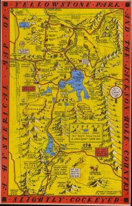
A Hysterical Map of Yellowstone Park and the Jackson Hole Country. Slightly Cockeyed.
sold
- Digital Map Information
- Suitable for large format printing
- File Size: 42.34 MB
- File Type: ZIP / TIFF
- ICC color profile embedded
- Delivered instantly via download link
This is a hilarious c. 1936 Jolly Lindgren pictorial map of Yellowstone National Park and Jackson Hole, Wyoming. The map depicts from Idaho to the Absaroka Range and from Montana to Jackson. Major roadways are marked in red with important locations, topography, and more illustrated pictorially. Humorous asides and illustrations are present throughout. Some of the amusing annotations include:
It has been argued that the bright colors and humorous nature of the map are intended to inspire good spirits against the backdrop of national social and economic depression - but such might be said of the entire genre of cartoon pictorial maps which were experiencing a golden age at this time. (more details)
- Old Faithful singing 'I'm Forever Blowing Bubbles'
- Fountain Paint Pot (It Stinks Too)
- Yellowstone Falls (And How)
- Wahb Springs (Just a Little Cold in the Head)
- Hamburgers (on the Hoof)
- Hot Springs (Mustn't Touch)
It has been argued that the bright colors and humorous nature of the map are intended to inspire good spirits against the backdrop of national social and economic depression - but such might be said of the entire genre of cartoon pictorial maps which were experiencing a golden age at this time. (more details)
Unrecorded state of Lindgren's map.
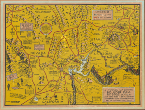
A Hysterical Map Showing Boulder Dam - The Grand Canyon - Zion Nat'l Park - Bryce Canyon - Cedar Breaks - Death Valley of Fire and the Los Angeles City Limits.
sold
- Digital Map Information
- Suitable for large format printing
- File Size: 21.47 MB
- File Type: ZIP / TIFF
- ICC color profile embedded
- Delivered instantly via download link
This is an unrecorded first state of Jolly Lindgren's 1936 silkscreen map of Boulder Dam and the Grand Canyon. This is one of Lindgren's most unusual maps, both for its scope and as an early example of his pioneering silkscreening work. The present example, on unusual brownish paper, is a previously unknown state, though all editions of this particular map are very rare. (more details)
'... just the companion I want at Grand Canyon For throwing old blades down the rock...'
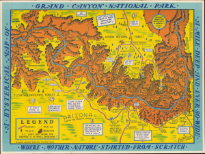
A Hysterical Map of Grand Canyon National Park. A Mile Deep and Ever So Wide. Where Mother Nature Started from Scratch.
sold
- Digital Map Information
- Suitable for large format printing
- File Size: 22.51 MB
- File Type: ZIP / TIFF
- ICC color profile embedded
- Delivered instantly via download link
This is a humorous 1940 Jolly Lindgren pictorial map of Grand Canyon National Park, one of the less common works from the Hysterical Map series. (more details)
One of the rarer maps in Jolly Lindgren's hysterical maps series.
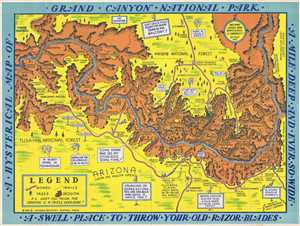
A Hysterical Map of Grand Canyon National Park. A Mile Deep and Ever So Wide. A Swell Place to Throw Your Old Razor Blades.
sold
- Digital Map Information
- Suitable for large format printing
- File Size: 8.77 MB
- File Type: ZIP / TIFF
- ICC color profile embedded
- Delivered instantly via download link
This is a humorous 1940 Jolly Lindgren pictorial map of Grand Canyon National Park, one of the rarer maps from the Hysterical Map series. The map depicts the Grand Canyon National Park from the Kanab Plateau and Mount Sinyala to the Painted Desert and from the ... (more details)
Hilarious map of Utah - as a puzzle!
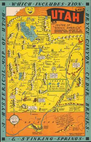
A Hysterical Map of Utah Which Includes Zion Bryce Canyon Cedar Breaks and Stinking Springs.
sold
- Digital Map Information
- Suitable for large format printing
- Full resolution TIFF file
- ICC color profile embedded
- Delivered instantly via download link
This is a c. 1940 Jolly Lindgren pictorial puzzle map of Utah - an unusual variant the Lindgren 'Hysterical' model. Composed in Lindgren's trademark style, cities and towns are labeled by small shacks, except for Salt Lake City, which is marked by the Mormon Temple. Bryce Canyon, Zion National Park, Dinosaur National Monument, and Arches National Monument are illustrated. Comical asides, part of Lindgren's charm, appear as well, marking Stinking Springs '(you may hold your nose)' and Hardup '(we're with you)'. The compass in the lower left reads, 'This proves it's a map!' (more details)
Hilarious pictorial map of Yellowstone National Park.
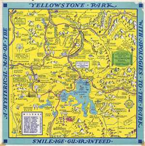
A Hysterical Map of the Yellowstone Park with Apologies to the Park. Smileage Guaranteed.
sold
- Digital Map Information
- Suitable for large format printing
- File Size: 6.45 MB
- File Type: ZIP / TIFF
- ICC color profile embedded
- Delivered instantly via download link
A cheerful 1948 pictorial map of Yellowstone Park, 'hatched and scratched' by the American printer and humorist Jolly Elmer Lindgren. The map depicts the whole of Yellowstone Park with a richly humorous array of vignettes and annotations. The map presents ... (more details)
Hilarious pictorial map of Yellowstone National Park.
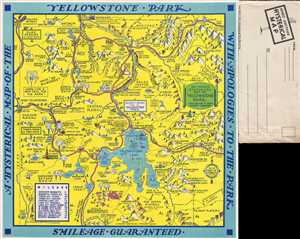
A Hysterical Map of the Yellowstone Park with Apologies to the Park. Smileage Guaranteed.
sold
- Digital Map Information
- Suitable for large format printing
- File Size: 6.57 MB
- File Type: ZIP / TIFF
- ICC color profile embedded
- Delivered instantly via download link
A cheerful 1948 pictorial map of Yellowstone Park, 'hatched and scratched' by the American printer and humorist Jolly Elmer Lindgren. The map depicts the whole of Yellowstone Park with a richly humorous array of vignettes and annotations. The map presents ... (more details)
A puzzle version of one of Jolly Lindgren's last creations!
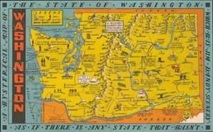
A Hysterical Map of the State of Washington Which Has Jim Dandy Scenery as if There is Any State That Hasn't.
sold
- Digital Map Information
- Suitable for large format printing
- Full resolution TIFF file
- ICC color profile embedded
- Delivered instantly via download link
This is a c. 1948 Jolly Lindgren postcard sized pictorial map of Washington State, published as a puzzle by the Lindgren-Turner Company. Cities and towns throughout are labeled, some of which include asides, such as 'Seattle - Can You Smell the Sound' and 'Walla Walla (They liked it so well they named it twice, like Sing Sing)'. Wenatchee is marked by an apple, owing to the annual Apple Blossom Festival, and Davenport is marked by a davenport. Mount Rainier National Park is illustrated, as is the Grand Coulee Dam on the Columbia River. A small legend is situated in the upper left corner, explaining the notations used for towns, trees, lakes, and mountains. (more details)
A large format postcard bearing one of the last maps published by Jolly Lindgren.
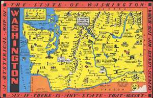
A Hysterical Map of the State of Washington - Which Has Jim Dandy Scenery - As If There Is Any State That Hasn't.
sold
- Digital Map Information
- Suitable for large format printing
- File Size: 1.25 MB
- File Type: ZIP / TIFF
- ICC color profile embedded
- Delivered instantly via download link
This is a c. 1948 Jolly Lindgren postcard sized pictorial map of Washington State. Drawn in Lindgren's trademark style and published as a 'king-size map card' by the Lindgren-Turner Company, the map depicts the state from the Pacific Ocean to Idaho and from Canada to Oregon. Cities and towns throughout the state are labeled, some of which include asides, including 'Seattle - Can You Smell the Sound' and 'Walla Walla (They liked it so well they named it twice, like Sing Sing)'. Wenatchee is marked by an apple, owing to the Apple Blossom Festival that is held that each year, and Davenport is marked by a davenport. Mount Rainier National Park is illustrated, as is the Grand Coulee Dam on the Columbia River. A small legend is situated in the upper left corner, explaining the notations used for towns, trees, lakes, and mountains. (more details)
The 'lowest' place.
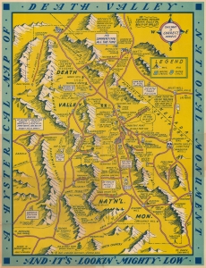
A blend of the comic and the practical, this is a 1948 Jolly Lindgren pictorial map of Death Valley National Monument. This is one of the rarer of Lindgren's 'Hysterical' map series, which gained popularity against the grim backdrop of first the Great Depression and World War II. (more details)
One of Lindgren's rarest National Park Maps.
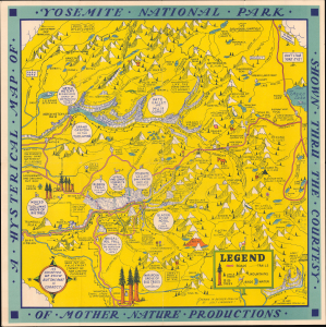
A Hysterical Map of Yosemite National Park shown through the Courtesy of Mother Nature Productions.
sold
- Digital Map Information
- Suitable for large format printing
- File Size: 289.23 MB
- File Type: ZIP / TIFF
- ICC color profile embedded
- Delivered instantly via download link
This is the Lindgren Brothers 1849 Hysterical Map of Yosemite National Park, accompanied by its original mailer. This is one of the rarest Jolly Lindgren pictorial maps, published late in their career. (more details)