
Owens, Charles Hamilton

Charles Hamilton Owens (Feb 16, 1881 - March 3, 1958) was an American painter and illustrator and staff illustrator for the Los Angeles Times. Born in San Francisco, he had a passion for drawing from a young age. After landing a job as a messenger for The San Francisco Examiner, Owens began being taught his trade by the newspaper's illustrators. Although it is unclear exactly where Owens started his career as a newspaper staff artist, his reputation was launched by his detailed sketches of the 1906 San Francisco earthquake and fire for a New York paper, using only wire reports and his knowledge of the city. By 1910, Owens was working for the Los Angeles Examiner. Even at this point in his career, Owens was known for experimenting with new forms of illustration, fusing drawings of events with photographs. Owens's map of the Titanic disaster used a high oblique perspective, 'capturing the earth's sphericity and showing the polar regions on a curving horizon.' By the 1920s, Owens reputation as an artist in Los Angeles had grown beyond the realm of journalism. He had a studio and received commissions for landscapes and had exhibited watercolors of California and Hawaii landscapes. Thus, when Owens began creating his war series in April/May 1942, he had all the necessary skills to create visually striking works. The Los Angeles Times began a series of maps for its readers, which were full-page inserts that would appear every Monday and Saturday. Owens's maps would be included in the Monday issues, and a Rand McNally map would be included on Saturdays. The Rand McNally maps, however, were discontinued on June 27, 1942, but Owens's maps continued to be printed. His last war map was published on September 10, 1945, a little over a week after the Japanese surrender. Owens died in Los Angeles on March 3, 1958.
Long Beach Oil Boom.
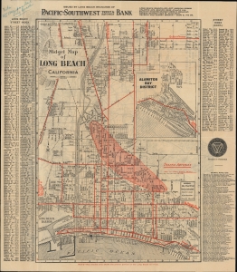
Midget Map of Long Beach California / Motor and Relief Map of Southern California.
$225.00
Acquire
- Digital Map Information
- Suitable for large format printing
- Full resolution TIFF file
- ICC color profile embedded
- Delivered instantly via download link
An absorbing 1925 'midget' folding map of Long Beach, California, produced by the Pacific-Southwest Trust and Savings Bank. Among other features, it is notable for highlighting the city's ongoing oil boom and a verso view of the developing road and highway network in the greater Los Angeles metropolitan area. (more details)
Highlighting all the important landmarks.
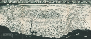
California. / California Official Tourist Picture Map.
$250.00
Acquire
- Digital Map Information
- Suitable for large format printing
- Full resolution TIFF file
- ICC color profile embedded
- Delivered instantly via download link
This is a c. 1936 Charles Hamilton Owens bird's eye view of California. This map was promoted and distributed by the All-Year-Club to promote California tourism. (more details)
The third in a series of maps of possible Allied invasions during the summer of 1943.
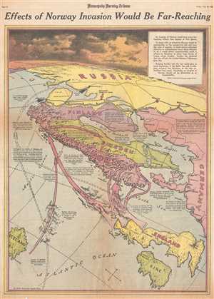
Effects of Norway Invasion Would Be Far-Reaching.
$250.00
Acquire
- Digital Map Information
- Suitable for large format printing
- File Size: 11.68 MB
- File Type: ZIP / TIFF
- ICC color profile embedded
- Delivered instantly via download link
This is a Friday, June 18, 1943 Charles Hamilton Owens and Minneapolis Morning Tribune map of the possible Allied invasion of Norway. The map depicts the region from the Arctic Ocean and Iceland to Germany and from Russia to Ireland. During the summer of 1943, ... (more details)
Includes an incredible view of an imagined Nazi aerial attack on Gibraltar.

Will Hitler Drive Into Spain For Thrust at Gibraltar?
$250.00
Acquire
- Digital Map Information
- Suitable for large format printing
- File Size: 10.45 MB
- File Type: ZIP / TIFF
- ICC color profile embedded
- Delivered instantly via download link
This is a Wednesday, January 6, 1943 Charles Hamilton Owens and Minneapolis Morning Tribune pictorial map of western Europe illustrating a possible Nazi German attack on Gibraltar. The most striking feature on the map is a view of Gibraltar, from the ... (more details)