1943 Owens Pictorial Map of Possible Nazi German Attack on Gibraltar
Gibraltar-owens-1943$250.00

Title
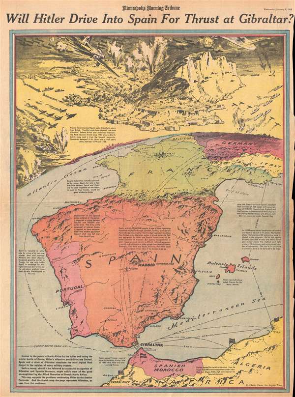
Will Hitler Drive Into Spain For Thrust at Gibraltar?
1943 (dated) 21.75 x 15.5 in (55.245 x 39.37 cm)
1943 (dated) 21.75 x 15.5 in (55.245 x 39.37 cm)
Description
This is a Wednesday, January 6, 1943 Charles Hamilton Owens and Minneapolis Morning Tribune pictorial map of western Europe illustrating a possible Nazi German attack on Gibraltar. The most striking feature on the map is a view of Gibraltar, from the southwest, during the imagined Nazi air raid, complete with fighter aircraft adorned Nazi insignia. The map depicts the region from the Atlantic Ocean to Berlin and from London to Morocco and Algeria. Created nearly two months after Operation Torch, the Allied invasion of French North Africa, the artist is presenting the possibility that Germany, which was now on the defensive in Russia and in North Africa, could decide to go on the offensive. Per 'many military experts', the 'most logical target' for this attack would be Spain and Gibraltar. Located on the Mediterranean coast just across the Strait of Gibraltar from Tangier, Gibraltar had been a British stronghold since 1704. It was also the location where General Dwight Eisenhower commanded Operation Torch.
Highlighting the current state of the war in the region, American flags are illustrated waving over Casablanca, Morocco, and Oran and Algiers, Algeria, since they had been captured/liberated by American forces in November. Gibraltar, is, of course, marked by a Union Jack. Numerous cities throughout the region are labeled, including Madrid, Paris, London, and Berlin, each of which include pictorial illustrations of famous buildings in that city. Vichy, France is also labeled. The most striking feature, as stated above, is the view of Gibraltar situated along the top border. Exquisitely detailed, numerous Nazi German aircraft are illustrated attacking the city and the Rock. Explosions and sinking ships, along with a few burning aircraft, perfect the image of the imagined carnage caused by such an attack.
Stylistically this cover owes a debt to the work of Richard Edes Harrison, an American illustrator and cartographer who, working for Fortune magazine, pioneered a new style of representing the world for WWII era propaganda maps. Edes developed the convention of using spherical perspective with an exaggerated vertical dimension, as on the present map, to illustrate part of the world as part of a greater global situation. This map was created by Charles Hamilton Owens for the Los Angeles Times and printed in the Minneapolis Morning Tribune on Wednesday, January 6, 1943.
CartographerS
Charles Hamilton Owens (Feb 16, 1881 - March 3, 1958) was an American painter and illustrator and staff illustrator for the Los Angeles Times. Born in San Francisco, he had a passion for drawing from a young age. After landing a job as a messenger for The San Francisco Examiner, Owens began being taught his trade by the newspaper's illustrators. Although it is unclear exactly where Owens started his career as a newspaper staff artist, his reputation was launched by his detailed sketches of the 1906 San Francisco earthquake and fire for a New York paper, using only wire reports and his knowledge of the city. By 1910, Owens was working for the Los Angeles Examiner. Even at this point in his career, Owens was known for experimenting with new forms of illustration, fusing drawings of events with photographs. Owens's map of the Titanic disaster used a high oblique perspective, 'capturing the earth's sphericity and showing the polar regions on a curving horizon.' By the 1920s, Owens reputation as an artist in Los Angeles had grown beyond the realm of journalism. He had a studio and received commissions for landscapes and had exhibited watercolors of California and Hawaii landscapes. Thus, when Owens began creating his war series in April/May 1942, he had all the necessary skills to create visually striking works. The Los Angeles Times began a series of maps for its readers, which were full-page inserts that would appear every Monday and Saturday. Owens's maps would be included in the Monday issues, and a Rand McNally map would be included on Saturdays. The Rand McNally maps, however, were discontinued on June 27, 1942, but Owens's maps continued to be printed. His last war map was published on September 10, 1945, a little over a week after the Japanese surrender. Owens died in Los Angeles on March 3, 1958. More by this mapmaker...
The Minneapolis Tribune (1867 - present) was founded by Colonel William S. King, William D. Washburn, and Dorilus Morrison and the first issue was published on May 25, 1867. In 1941, the Cowles family of Des Moines, Iowa bought the Tribune and merged it with their other holdings in Minneapolis, giving the Cowles family ownership of all the city's major newspapers. The Tribune became the city's morning newspaper, and the Star-Journal was the evening newspaper. The two published a joint Sunday edition. The newspaper is still published today, under the name Star Tribune. Learn More...
Condition
Good. Newsprint. Even overall toning. Closed tears along left and right margins professionally repaired on verso. Text on verso.