
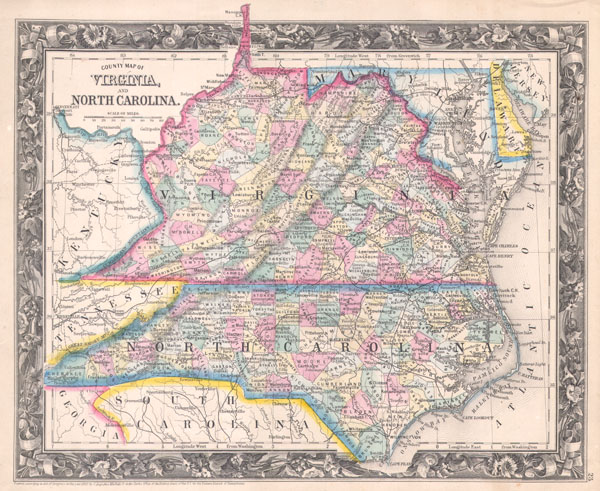
County Map of Virginia, and North Carolina.
sold
- Digital Map Information
- Suitable for large format printing
- File Size: 3.85 MB
- File Type: ZIP / TIFF
- ICC color profile embedded
- Delivered instantly via download link
One of the most difficult to find atlas maps issued by S. A. Mitchell Jr. From the first edition (1860) of Mitchell's Mitchell's New General Atlas , depicts a unified Virginia with North Carolina. Includes parts of Kentucky, Tennessee, Maryland, Georgia, South ... (more details)

Map of Asia Showing its Gt. Political Divisions, and also the various Routes of Travel Between Lond & India, China & Japan & C.
sold
- Digital Map Information
- Suitable for large format printing
- File Size: 4.67 MB
- File Type: ZIP / TIFF
- ICC color profile embedded
- Delivered instantly via download link
A beautiful example of S. A. Mitchell Jr.'s 1864 map of the Asia. Makes note of the steamship routes and mileages from London to various destinations in Asia. Denotes both political and geographical details. One of the most attractive American atlas maps of ... (more details)
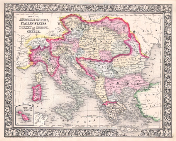
Map of the Austrian Empire, Italian States. Turkey in Europe, and Greece.
sold
- Digital Map Information
- Suitable for large format printing
- File Size: 4.42 MB
- File Type: ZIP / TIFF
- ICC color profile embedded
- Delivered instantly via download link
A beautiful example of S. A. Mitchell Jr.'s 1864 map of the Austrian Empire, Italy, Turkey in Europe and Greece. An inset in the lower left quadrant features the Maltese Islands. Denotes both political and geographical details. When this map was made Italy ... (more details)

County Map of England, and Wales.
sold
- Digital Map Information
- Suitable for large format printing
- File Size: 4.45 MB
- File Type: ZIP / TIFF
- ICC color profile embedded
- Delivered instantly via download link
A beautiful example of S. A. Mitchell Jr.'s 1864 map of England and Wales. Denotes both political and geographical details. One of the most attractive American atlas maps of this region to appear in the mid 19th century. Features the floral border typical ... (more details)

Ireland in Provinces and Counties. / County Map of Scotland.
sold
- Digital Map Information
- Suitable for large format printing
- File Size: 4.54 MB
- File Type: ZIP / TIFF
- ICC color profile embedded
- Delivered instantly via download link
A beautiful example of S. A. Mitchell Jr.'s 1864 two map sheet depicting Ireland on the left and Scotland on the right. Inset in the upper left quadrant of the Scotland map depicts the Shetland Islands. Denotes both political and geographical details. One ... (more details)

Prussia and the German States.
sold
- Digital Map Information
- Suitable for large format printing
- File Size: 4.31 MB
- File Type: ZIP / TIFF
- ICC color profile embedded
- Delivered instantly via download link
A beautiful example of S. A. Mitchell Jr.'s 1864 map of Prussia and Germany. Depicts the German states from the border with Holland and Belgium eastward as far as Poland and Russia. Extends south into Austria and Bohemia (the modern day Czech Republic). ... (more details)

Map of Europe, showing its Gt. Political Divisions.
sold
- Digital Map Information
- Suitable for large format printing
- File Size: 3.59 MB
- File Type: ZIP / TIFF
- ICC color profile embedded
- Delivered instantly via download link
A beautiful example of S. A. Mitchell Jr.'s 1864 map of Europe. Depicts all of Europe including Iceland. Extends eastwards as far as the Ural Mountains and southward to include parts of North Africa and Turkey. Denotes both political and geographical ... (more details)
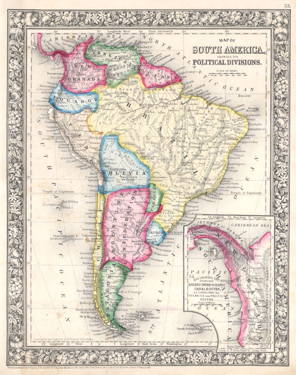
Map of South America, showing its Political Divisions.
sold
- Digital Map Information
- Suitable for large format printing
- File Size: 4.21 MB
- File Type: ZIP / TIFF
- ICC color profile embedded
- Delivered instantly via download link
A beautiful example of S. A. Mitchell Jr.'s 1864 map of South America. Depicts the whole of the continent, including Panama, in considerable detail. Denotes both political and geographical details. Surprisingly accurate detail of the interior of ... (more details)

Map of New Granada, Venezuela, and Guiana. / Map of Peru and Equador. / Map of the Argentine Confederation.
sold
- Digital Map Information
- Suitable for large format printing
- File Size: 4.48 MB
- File Type: ZIP / TIFF
- ICC color profile embedded
- Delivered instantly via download link
A beautiful example of S. A. Mitchell Jr.'s 1864 three map sheet depicting parts of South America. The first map shows New Granada (Columbia), Venezuela and Guiana. The second map, in the lower left quadrant, depicts Peru and Equador (Ecuador). ... (more details)

County Map of Nova Scotia, New Brunswick, Cape Breton Is. And Pr. Edward's Id.
sold
- Digital Map Information
- Suitable for large format printing
- File Size: 3.69 MB
- File Type: ZIP / TIFF
- ICC color profile embedded
- Delivered instantly via download link
A beautiful example of S. A. Mitchell Jr.'s 1864 map of Canadian Maritime Provinces of Nova Scotia, New Brunswick, Prince Edward's Island, and Cape Breton Island. Detailed to the county level with special attention both political and geographic ... (more details)

Map of Canada West in Counties.
sold
- Digital Map Information
- Suitable for large format printing
- File Size: 4.06 MB
- File Type: ZIP / TIFF
- ICC color profile embedded
- Delivered instantly via download link
A beautiful example of S. A. Mitchell Jr.'s 1864 map of Canada West, or as it is now known, Ontario. Detailed to the county level with special attention both political and geographic elements. Notes important river systems, railways, canals, ... (more details)

Map of Louisiana, Mississippi and Arkansas.
sold
- Digital Map Information
- Suitable for large format printing
- File Size: 3.91 MB
- File Type: ZIP / TIFF
- ICC color profile embedded
- Delivered instantly via download link
A beautiful example of S. A. Mitchell Jr.'s 1864 map of Louisiana, Mississippi and Arkansas. Detailed to the county level with special attention both political and geographic elements. Notes important river systems, railways, canals, and ... (more details)
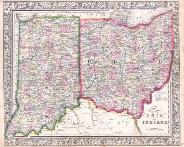
County map of Ohio and Indiana.
sold
- Digital Map Information
- Suitable for large format printing
- File Size: 4.66 MB
- File Type: ZIP / TIFF
- ICC color profile embedded
- Delivered instantly via download link
A beautiful example of S. A. Mitchell Jr.'s 1864 map of Ohio and Indiana. Detailed to the county level with special attention both political and geographic elements. Notes important river systems, railways, canals, and cities. Updated ... (more details)

County Map of Michigan and Wisconsin.
sold
- Digital Map Information
- Suitable for large format printing
- File Size: 4.56 MB
- File Type: ZIP / TIFF
- ICC color profile embedded
- Delivered instantly via download link
A beautiful example of S. A. Mitchell Jr.'s 1864 map of Michigan and Wisconsin. Detailed to the county level with special attention both political and geographic elements. Notes important river systems, railways, canals, and cities. ... (more details)

Plan of Philadelphia.
sold
- Digital Map Information
- Suitable for large format printing
- File Size: 4.17 MB
- File Type: ZIP / TIFF
- ICC color profile embedded
- Delivered instantly via download link
A beautiful example of S. A. Mitchell Jr.'s 1864 map of Philadelphia, Pennsylvania. Depicts the city of Philadelphia along with parts Camden. Offers wonderful detail at the street level including references to the individual ... (more details)

County Map of Florida. / County Map of North Carolina. / Map of South Carolina.
sold
- Digital Map Information
- Suitable for large format printing
- File Size: 4.72 MB
- File Type: ZIP / TIFF
- ICC color profile embedded
- Delivered instantly via download link
A beautiful example of S. A. Mitchell Jr.'s 1864 map of North Carolina, South Carolina and Florida. Detailed to the county level with special attention both political and geographic elements. Notes important river systems, ... (more details)

A New Map of Palestine or the Holy Land.
sold
- Digital Map Information
- Suitable for large format printing
- File Size: 3.6 MB
- File Type: ZIP / TIFF
- ICC color profile embedded
- Delivered instantly via download link
A beautiful example of S. A. Mitchell Jr.'s 1864 map of Palestine, Israel or the Holy Land. Updated from the 1860 variant with new details, an inset of Jerusalem, and a new 1864 copyright. Includes both political and ... (more details)

Map of Hindoostan, Farther India, China, and Tibet.
sold
- Digital Map Information
- Suitable for large format printing
- File Size: 4.24 MB
- File Type: ZIP / TIFF
- ICC color profile embedded
- Delivered instantly via download link
A beautiful example of S. A. Mitchell Jr.'s 1864 map of the India, Tibet, China and Southeast Asia, including Burma, Thailand, Cambodia, and Vietnam. Covers the region in considerable detail with parts of Malaysia, ... (more details)
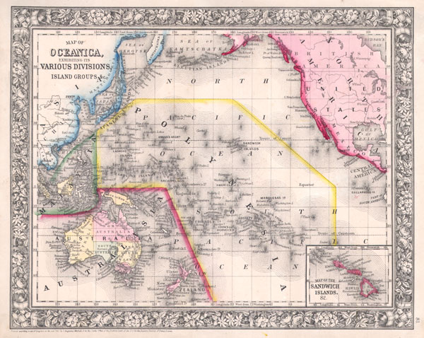
Map of Oceanica, Exhibiting its Various Divisions, Island Groups & c.
sold
- Digital Map Information
- Suitable for large format printing
- File Size: 4.39 MB
- File Type: ZIP / TIFF
- ICC color profile embedded
- Delivered instantly via download link
A beautiful example of S. A. Mitchell Jr.'s 1864 map of the Pacific, including Australia, Polynesia, Melanesia and Malaysia. Covers the region in considerable detail with parts of North America and Asia included. ... (more details)

Map of Africa showing itsmost Recent Discoveries.
sold
- Digital Map Information
- Suitable for large format printing
- File Size: 4.14 MB
- File Type: ZIP / TIFF
- ICC color profile embedded
- Delivered instantly via download link
A beautiful example of S. A. Mitchell Jr.'s 1864 map of Africa and St. Helena. Covers the continent in considerable detail considering the level to which it was explored at the time. The first of the Mitchell ... (more details)