
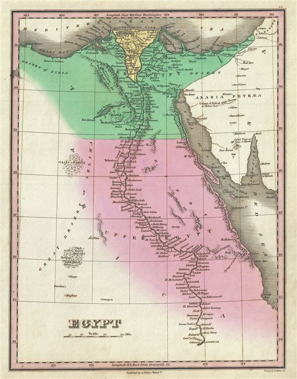
Egypt.
sold
- Digital Map Information
- Suitable for large format printing
- DPI: 300
- File Size: 3.12 MB
- File Type: ZIP / TIFF
- ICC color profile embedded
- Delivered instantly via download link
This is a beautiful example of Finley's important 1827 map of Egypt. It depicts Egypt, centered on the Nile River, and extending south as far as Aswan and names numerous settlements and villages along the course of the river, including a number of temples and ... (more details)
The first map to show Kansas and Nebraska in full, including western parts.
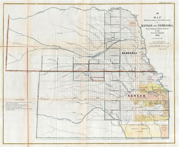
Map Showing the progress of the Public Surveys in Kansas and Nebraska.
sold
- Digital Map Information
- Suitable for large format printing
- File Size: 17.9 MB
- File Type: ZIP / TIFF
- ICC color profile embedded
- Delivered instantly via download link
This is an impressive example of the 1863 public survey map of Kansas and Nebraska by Mark W. Delahay, Surveyor General of Kansas and Nebraska. It covers the region from the Missouri Rivers to the western boundary of Nebraska and from the Neobrarah (Niobrara) ... (more details)

Johnson's North and South Carolina.
sold
- Digital Map Information
- Suitable for large format printing
- File Size: 18.92 MB
- File Type: ZIP / TIFF
- ICC color profile embedded
- Delivered instantly via download link
This is a beautiful example of A. J. Johnson and Ward's 1863 map of North Carolina and South Carolina. It offers a fascinating snapshot of these states during the American Civil War. Map shows both states in full with color coding according to county. An ... (more details)

A Diagram Exhibiting the difference of time between the places shown and Washington.
sold
- Digital Map Information
- Suitable for large format printing
- File Size: 7.59 MB
- File Type: ZIP / TIFF
- ICC color profile embedded
- Delivered instantly via download link
A very attractive example of Johnson and Ward's 1863 diagram of the world's time zones. Consists of a circular engraving in which numerous clocks are drawn, each representing a major world city. At the center is clock representing the time in Washington, ... (more details)

Johnson's Georgetown and the City of Washington The Capital of the United States of America.
sold
- Digital Map Information
- Suitable for large format printing
- File Size: 8.12 MB
- File Type: ZIP / TIFF
- ICC color profile embedded
- Delivered instantly via download link
A beautiful example of Johnson and Ward's 1863 map of Washington D.C. and Georgetown. It offers a fascinating snapshot of the Union capital in the midst of the American Civil War. Shows the city in considerable detail with color coding according to ... (more details)

Johnson's Delaware and Maryland.
sold
- Digital Map Information
- Suitable for large format printing
- File Size: 8.93 MB
- File Type: ZIP / TIFF
- ICC color profile embedded
- Delivered instantly via download link
This is a fine Johnson and Ward map of Maryland and Delaware dating to 1863. Covers both states as well as the capital district in considerable detail. This is the most decorative of Johnson's Maryland-Delaware series with engraved views along the ... (more details)

Johnson's Florida.
sold
- Digital Map Information
- Suitable for large format printing
- File Size: 7.92 MB
- File Type: ZIP / TIFF
- ICC color profile embedded
- Delivered instantly via download link
A beautiful example of A. J. Johnson and Ward's 1863 map of Florida. This rare map offers a fascinating snapshot of this secessionist state shortly following the outbreak of the American Civil War. Map shows Florida in full with color coding ... (more details)

Johnson's Nebraska Dakota, Colorado Idaho and Kansas.
sold
- Digital Map Information
- Suitable for large format printing
- File Size: 7.91 MB
- File Type: ZIP / TIFF
- ICC color profile embedded
- Delivered instantly via download link
This is Johnson and Ward's rare 1863 map of the territories of Idaho, Dakota, Nebraska, Colorado and Kansas. Extends west as far as the Great Salt Lake and east to Lake Superior. It depicts this area during an interesting transitional phase ... (more details)

Johnson's Minnesota and Dakota.
sold
- Digital Map Information
- Suitable for large format printing
- File Size: 8.78 MB
- File Type: ZIP / TIFF
- ICC color profile embedded
- Delivered instantly via download link
This is a beautiful example of Johnson and Ward's 1863 map of Minnesota and Dakota. It covers both states as well as parts of adjacent parts of Wisconsin and Iowa. This map predates the splitting of the Dakotas and instead depicts them as a ... (more details)

Johnson's Washington Oregon and Idaho.
sold
- Digital Map Information
- Suitable for large format printing
- File Size: 7.35 MB
- File Type: ZIP / TIFF
- ICC color profile embedded
- Delivered instantly via download link
This is Johnson and Ward's beautifully hand colored 1863 map of Washington, Oregon, and Idaho, with parts of modern day Montana and Wyoming. This map shows cities, topographical features, railways, ferries and roads with color coding at the ... (more details)

Johnson's Mexico.
sold
- Digital Map Information
- Suitable for large format printing
- File Size: 8.43 MB
- File Type: ZIP / TIFF
- ICC color profile embedded
- Delivered instantly via download link
An excellent 1863 example of Johnson and Ward's map of Mexico and Texas. Like most of Johnson's maps, this map was derived from an earlier map by J. H. Colton issued in 1855. Covers all of modern day Mexico as well as most of Texas, ... (more details)

Johnson's Central America.
sold
- Digital Map Information
- Suitable for large format printing
- File Size: 8.66 MB
- File Type: ZIP / TIFF
- ICC color profile embedded
- Delivered instantly via download link
A beautiful 1863 example of Johnson and Ward's map of the Central America. It covers from the Yucatan southeast as far as Panama and north as far as Jamaica. Like most of Johnson's North America maps, this map is largely derived ... (more details)
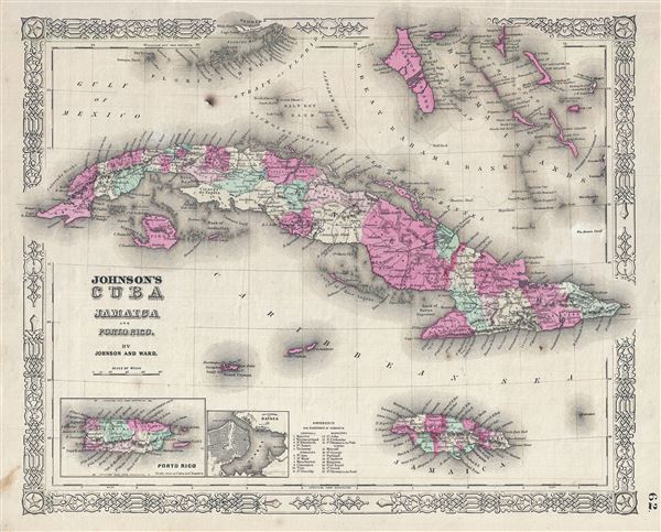
Johnson's Cuba Jamaica and Porto Rico.
sold
- Digital Map Information
- Suitable for large format printing
- File Size: 8.62 MB
- File Type: ZIP / TIFF
- ICC color profile embedded
- Delivered instantly via download link
This is a beautiful example of Johnson and Ward's 1863 map of Cuba, Jamaica, the Bahamas and Puerto Rico. Also shows part of the Florida Keys. The map offers superb detail of the entire region including roadways, cities, ... (more details)
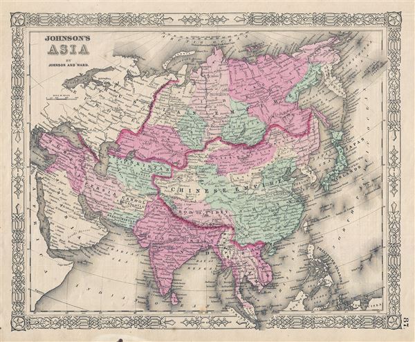
Johnson's Asia.
$100.00
Acquire
- Digital Map Information
- Suitable for large format printing
- File Size: 9.01 MB
- File Type: ZIP / TIFF
- ICC color profile embedded
- Delivered instantly via download link
A very nice example of Johnson and Ward's 1863 map of Asia. Covers from the Arabian Peninsula and Turkey eastward as far as Kamchatka, Japan, the Philippines and New Guinea. Shows the Empires of Hindoostan (India), China ... (more details)

Johnson's Palestine.
sold
- Digital Map Information
- Suitable for large format printing
- File Size: 8.12 MB
- File Type: ZIP / TIFF
- ICC color profile embedded
- Delivered instantly via download link
This is a beautiful example of Johnson and Ward's 1863 map of Palestine, Israel or the Holy Land. It details the region from Beirut south to Busaireh and Kadesh Barnea and extends eastward as far as Mount Alsadamus in ... (more details)

Johnson's China.
sold
- Digital Map Information
- Suitable for large format printing
- File Size: 8.38 MB
- File Type: ZIP / TIFF
- ICC color profile embedded
- Delivered instantly via download link
This is Johnson and Ward's 1863 map of China, covering from Mongolia to Hainan and from Tibet to Korea. The map identifies both the Great Wall and the Grand Canal. It depicts the region with particular attention to ... (more details)
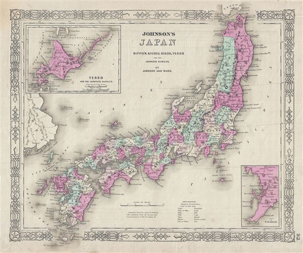
Johnson's Japan Nippon, Kiusiu, Sikok, Yesso and the Japanese Kuriles.
sold
- Digital Map Information
- Suitable for large format printing
- File Size: 8.31 MB
- File Type: ZIP / TIFF
- ICC color profile embedded
- Delivered instantly via download link
This is Johnson and Ward's 1863 map of Japan. Compiled by A. J. Johnson from the map of Siebold with additions from the surveys and reconnaissance of the U.S. Japan expedition, this map covers the Japanese Islands ... (more details)

Johnson's Turkey in Asia Persia Arabia etc.
sold
- Digital Map Information
- Suitable for large format printing
- File Size: 8.38 MB
- File Type: ZIP / TIFF
- ICC color profile embedded
- Delivered instantly via download link
This is a very nice example of Johnson and Ward's 1863 map of Arabia, Persia and Turkey in Asia. It covers from the Mediterranean and Egypt eastwards as far as the Mouths of the Indus River, as well as southward ... (more details)

Johnson's Hindostan or British India
sold
- Digital Map Information
- Suitable for large format printing
- File Size: 9.06 MB
- File Type: ZIP / TIFF
- ICC color profile embedded
- Delivered instantly via download link
This is a very nice example of Johnson and Ward's 1863 map of India and Southeast Asia. It covers from the mouths of the Indus River eastward to include all of India, Burma, Siam (Thailand), Laos, Cambodia, ... (more details)

Johnson's Australia.
sold
- Digital Map Information
- Suitable for large format printing
- File Size: 7.41 MB
- File Type: ZIP / TIFF
- ICC color profile embedded
- Delivered instantly via download link
This is Johnson and Ward's 1863 map of Australia. The map covers the entire continent including Tasmania or Van Diemen's Land. Johnson's mappings of Australia, updated annually through the 1860s, offer a ... (more details)