
Offers both contemporary and historical cartographies.

Palestine & Adjacent Countries.
sold
- Digital Map Information
- Suitable for large format printing
- DPI: 300
- File Size: 7.94 MB
- File Type: ZIP / TIFF
- ICC color profile embedded
- Delivered instantly via download link
A fine example of Thomas Cowperthwait and S. A. Mitchell's 1854 map of Palestine, Israel, or the Holy Land. This map is a curious combination of a contemporary and a historic map. The color coding details the region as it may have appeared in Biblical times, ... (more details)

West Indies.
sold
- Digital Map Information
- Suitable for large format printing
- Full resolution TIFF file
- ICC color profile embedded
- Delivered instantly via download link
A fine example of Thomas Cowperthwait and S. A. Mitchell's 1854 map of West Indies. Covers from Florida and the Bahamas south through the Caribbean islands of Cuba and Hispaniola (Haiti & the Dominican Republic) to the northern Part of South America and east to ... (more details)
Shows the embryonic beginnings of the Pacific Railroad.

A New Map of the State of Missouri.
sold
- Digital Map Information
- Suitable for large format printing
- DPI: 300
- File Size: 9.34 MB
- File Type: ZIP / TIFF
- ICC color profile embedded
- Delivered instantly via download link
A fine example of Thomas Cowperthwait and S. A. MitchellÂ's 1854 map of Missouri. The map outlines with vivid detail counties, survey platting, towns, topography, and one railroad route from St. Louis to Jefferson City. This fledging railroad route is in fact ... (more details)
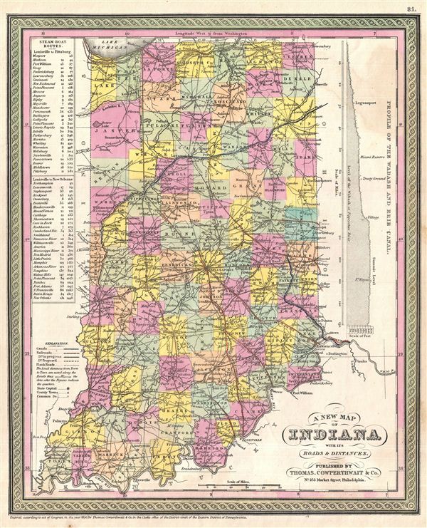
A New Map of Indiana with its Roads & Distances.
sold
- Digital Map Information
- Suitable for large format printing
- DPI: 300
- File Size: 6.56 MB
- File Type: ZIP / TIFF
- ICC color profile embedded
- Delivered instantly via download link
A fine example of Thomas Cowperthwait and S. A. Mitchell's 1854 map of Indiana presenting a profile of the Wabash and Erie Canal along the upper right border. Indiana's many canals and railroad lines are highlighted in blue and orange, respectively. Steam Boat ... (more details)

A New Map of Michigan with its Canals, Roads & Distances.
sold
- Digital Map Information
- Suitable for large format printing
- DPI: 300
- File Size: 6.91 MB
- File Type: ZIP / TIFF
- ICC color profile embedded
- Delivered instantly via download link
A fine example of Thomas Cowperthwait and S. A. Mitchell's 1854 map of Michigan. The whole is engraved and colored in Mitchell's distinctive style with green border work and vivid pastels. Political and topographical features are noted and color coded with ... (more details)
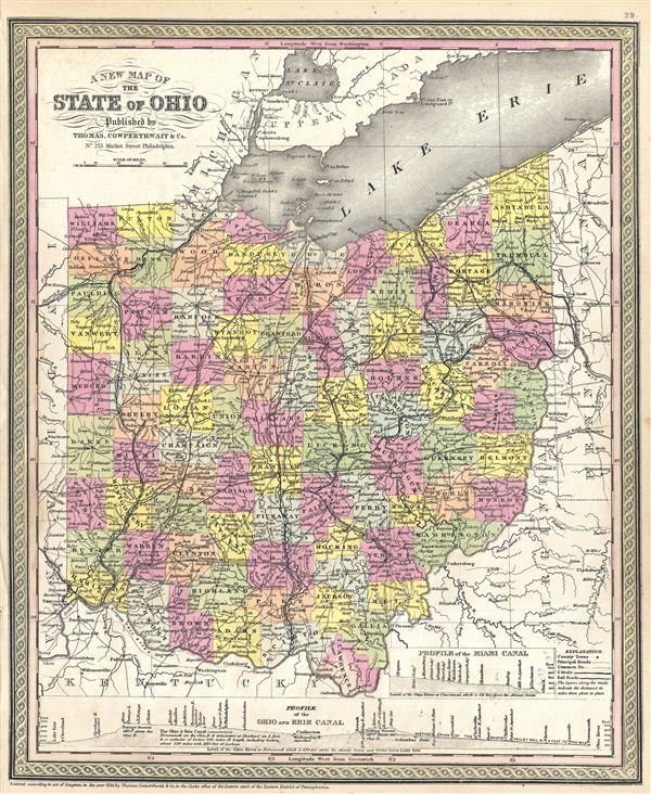
A New Map of the State of Ohio.
sold
- Digital Map Information
- Suitable for large format printing
- DPI: 300
- File Size: 9 MB
- File Type: ZIP / TIFF
- ICC color profile embedded
- Delivered instantly via download link
A fine example of Thomas Cowperthwait and S. A. Mitchell's 1854 map of Ohio with a profile of the Ohio and Erie Canal along the lower border. A smaller profile of the Miami Canal is also presented in the lower right quadrant. On the map proper, Ohio's many ... (more details)

A New Map of Kentucky with its Canals, Roads & Distances from place to place, along the Stage & Steam Boat Routes.
sold
- Digital Map Information
- Suitable for large format printing
- DPI: 300
- File Size: 6.63 MB
- File Type: ZIP / TIFF
- ICC color profile embedded
- Delivered instantly via download link
A fine example of Thomas Cowperthwait and S. A. Mitchell's 1854 map of Kentucky with three inset maps: environs of Lexington in the upper left quadrant, Falls of the Ohio River in the lower left, and the route between Washington and Clarksburg in the lower ... (more details)

A New Map of Tennessee with its Canals, Roads & Distances from place to place, along the Stage & Steam Boat Routes.
sold
- Digital Map Information
- Suitable for large format printing
- DPI: 300
- File Size: 7.5 MB
- File Type: ZIP / TIFF
- ICC color profile embedded
- Delivered instantly via download link
A fine example of Thomas Cowperthwait and S. A. Mitchell's 1854 map of Tennessee with two inset maps: environs of Nashville and Knoxville in the upper left and right quadrants, respectively. Steam Boat routes along with distances in tabular format are ... (more details)

A New Map of Arkansas with its Canals, Roads & Distances.
sold
- Digital Map Information
- Suitable for large format printing
- DPI: 300
- File Size: 6.05 MB
- File Type: ZIP / TIFF
- ICC color profile embedded
- Delivered instantly via download link
A fine example of Thomas Cowperthwait and S. A. Mitchell's 1854 map of Arkansas. The whole is engraved and colored in Mitchell's distinctive style with green border work and vivid pastels. Political and topographical features are noted and color ... (more details)
One of the finest maps of Arabia to appear in the 19th century.

Arabia, Egypt, Abyssinia, Red Sea & c.
sold
- Digital Map Information
- Suitable for large format printing
- DPI: 300
- File Size: 17.86 MB
- File Type: ZIP / TIFF
- ICC color profile embedded
- Delivered instantly via download link
This is an exceptionally fine example of John Thomson's 1814 map of Arabia, Egypt, and Abyssinia. Centered on the Arabian Peninsula, Thomson's map covers from the eastern Mediterranean to the Horn of Africa, and from the Libyan Desert to Persia. ... (more details)
Shows the apocryphal island of St. John east of the Philippines.
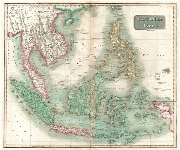
East India Isles.
sold
- Digital Map Information
- Suitable for large format printing
- DPI: 300
- File Size: 13.52 MB
- File Type: ZIP / TIFF
- ICC color profile embedded
- Delivered instantly via download link
This is an exceptionally fine example of John Thomson's 1814 map of Southeast Asia and the East India Islands. Centered on Borneo, Thomson's map covers from China and Hainan south to Sumatra and Java, and eastward as far as the Philippines and ... (more details)
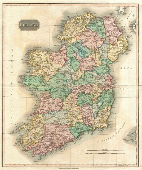
Ireland.
sold
- Digital Map Information
- Suitable for large format printing
- DPI: 300
- File Size: 18.32 MB
- File Type: ZIP / TIFF
- ICC color profile embedded
- Delivered instantly via download link
This is an exceptionally fine example of John Thomson's 1814 map of Ireland. Thomson uses color coding to break down the island into its many counties. The whole is beautifully engraved in the minimalist English style pioneered in the early ... (more details)

San Francisco.
sold
- Digital Map Information
- Suitable for large format printing
- File Size: 1.81 MB
- File Type: ZIP / TIFF
- ICC color profile embedded
- Delivered instantly via download link
A lovely petite c. 1860 view of San Francisco by W. L. Ormsby. This small but beautifully view shows the city and Harbor of San Francisco with military in the surrounding hills. This was engraved at the height of San Francisco's ... (more details)

Het Beloofde Landt Canaan door wandelt van onsen Salichmaecker Iesu Christo nessens syne Apostelen.
sold
- Digital Map Information
- Suitable for large format printing
- DPI: 300
- File Size: 9.1 MB
- File Type: ZIP / TIFF
- ICC color profile embedded
- Delivered instantly via download link
This is a splendid early example of Bastiaan Stoopendaal and Jacob Keur's c. 1730 map of Canaan (Israel or Palestine). Oriented to the west, this map covers the Holy Land from the Mediteranean to just beyond the Jordan River. This ... (more details)

De Beschryvingh van de Reysen Pauli, en van de Andere Apostelen.
sold
- Digital Map Information
- Suitable for large format printing
- Full resolution TIFF file
- ICC color profile embedded
- Delivered instantly via download link
This is a splendid early example of Daniel Stoopendaal and Jacob Keur's c. 1730 map of the travels of the Apostle Paul. Covers the eastern Mediterranean from Sicily to the Holy Land and inland as far as the Persian Gulf and the ... (more details)

A New Map of Louisiana with its canals, roads & Distances from place to place, along the Stage & Steam Boat Routes.
sold
- Digital Map Information
- Suitable for large format printing
- DPI: 300
- File Size: 6.88 MB
- File Type: ZIP / TIFF
- ICC color profile embedded
- Delivered instantly via download link
A fine example of Thomas Cowperthwait and S. A. Mitchell's 1854 map of Louisiana with an inset of New Orleans in the upper right quadrant. Steam bout routes along with distances are presented in tabular format along the left ... (more details)

A New Map of Mississippi with its Roads & Distances.
sold
- Digital Map Information
- Suitable for large format printing
- DPI: 300
- File Size: 6.52 MB
- File Type: ZIP / TIFF
- ICC color profile embedded
- Delivered instantly via download link
A fine example of Thomas Cowperthwait and S. A. Mitchell's 1854 map of Mississippi. Steam bout routes along with distances are presented in tabular format in the lower left quadrant. The whole is engraved and colored in ... (more details)

A New Map of Alabama with its Roads & Distances from place to place, along the Stage & Steam Boat Routes.
sold
- Digital Map Information
- Suitable for large format printing
- DPI: 300
- File Size: 6.56 MB
- File Type: ZIP / TIFF
- ICC color profile embedded
- Delivered instantly via download link
A fine example of Thomas Cowperthwait and S. A. Mitchell's 1854 map of Alabama. Steam bout routes along with distances are presented in tabular format along the left border. The whole is engraved and colored in ... (more details)

Map of Florida.
sold
- Digital Map Information
- Suitable for large format printing
- DPI: 300
- File Size: 6.39 MB
- File Type: ZIP / TIFF
- ICC color profile embedded
- Delivered instantly via download link
A fine example of Thomas Cowperthwait and S. A. Mitchell's 1854 map of Florida. Mitchell's map covers the entire state in considerable detail with towns, cities, counties, swamps, and reefs noted. Water routes ... (more details)

A New Map of Georgia with its Roads & Distances.
sold
- Digital Map Information
- Suitable for large format printing
- DPI: 300
- File Size: 6.87 MB
- File Type: ZIP / TIFF
- ICC color profile embedded
- Delivered instantly via download link
A fine example of S. A. Mitchell's 1854 new map of Georgia. Through its elegant design, this map of Georgia centers our attention on the roads and railroads that crisscross the state. Steamboat routes and ... (more details)