This item has been sold, but you can get on the Waitlist to be notified if another example becomes available, or purchase a digital scan.
1690 Coronelli Map of Ethiopia, Abyssinia, and the Source of the Blue Nile
Abissinia-coronelli-1690$475.00

Title
Abissinia, doue sono le Fonti del Nilo descritta secondo le relationi de P.P. Mendez, Almeida, Pais, Lobo, e Lodulfo del P. M. Coronelli M.C. Cosmografo della Seren. Rep. di Ventia…
1690 (undated) 19 x 25 in (48.26 x 63.5 cm)
1690 (undated) 19 x 25 in (48.26 x 63.5 cm)
Description
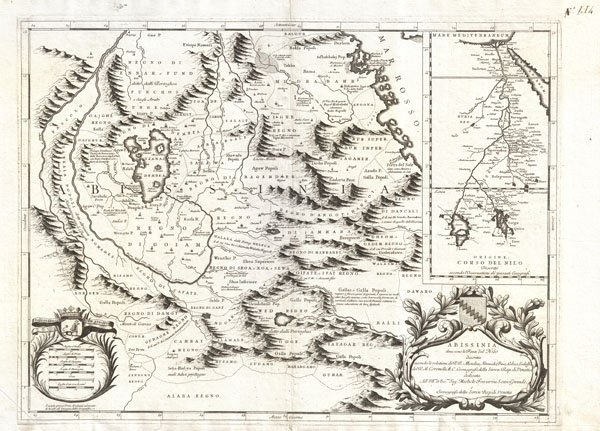
This is Coronelli's important 1690 map of Ethiopia (Abyssinia) showing the source of the Blue Nile. This map, focusing on Lake Tana (Tzana Dembea) covers the Ethiopian highlands from Derbeta on the Red Sea south as far as the tribal kingdoms of Sugame, Bahargamo and Gumar, all of which are located in modern southern Ethiopia. Europeans, Coronelli included, had a great interest in this region not only because of common conjecture regarding the source of the Nile, but also as a potential site of the Kingdom of Prester John. Though often underappreciated by historians, this is a highly significant map in the development of African cartography and, from the early 18th century on, most cartographers followed its example with regard to this important region - one of the few parts of sub-Saharan Africa to be accurately represented on maps prior to the late 19th century.
Coronelli claims that this is the first map to accurately depict the sources of the Nile and, at least as regards the Blue Nile, we see no reason to dispute his claim. The cartography here is based upon the travels of Portuguese Jesuits Manuel de Almeida, Affonso Mendez, Pedro Páez, and Jerónimo Lobo, who traveled throughout Abyssinia in the mid 16th century. Coronelli correctly recognizes the importance of Lake Tana (Tzana Dembea) as well as the curious turn in the river that actually causes the Blue Nile to start it course as a southerly flowing river. The actual fonts of the Nile itself appear to the southwest of Lake Tana. The Falls of the Blue Nile, now a popular tourist destination in Ethiopia, are noted just south of the Lake.
In the upper right quadrant Coronelli contrasts his perspective on the region with the traditional Ptolemaic representation of the Nile River stemming from two great lakes south of the Equator. Ironically, both perspectives are somewhat correct. Coronelli's representation of Abysinnia is highly accurate with regard to the course of the Blue Nile and its sources. On the other hand, along with the Ptolemaic theory, Coronelli seems to ignore the entire White Nile which meanders into non-existence in the extreme left hand quadrants of the map. The Ptolemaic perspective depicted on the upper right, though it is based on speculative accounts dating to antiquity, actually offers a fairly accurate representation of the White Nile's course northward from Lake Victoria, which is in fact located just below the Equator.
Coronelli's map also offers much of interest beyond its intended purpose - that is to show the course of the Nile. A number of the earliest Ethiopian towns, cities, monasteriesc,and kingdoms, many of which still exist, are in evidence. These include Axum, Asmara, Gojiam, di Cafate (Kaffa), di Ganz , di Dembea (north of Lake Tana), Tigre, di Amhara (welo), Ifat, Guraghe, Damot, Balli, Dawaro, Sugamo (Sidamo?), Angot, Bagemder and Midrabahr ( Bahrmedr), among others. Curiously the map does not name the early Abyssinian capital city of Gondar, though the tent encampment of the King is roughly identified in the same location.
A decorative title cartouche appears on the lower right quadrant. Another cartouche, showing a no less than six distance scales adorns the lower left. This map was issued as plate no 114 in Coronelli's stupendous 1690 Atlante veneto
Cartographer
Vincenzo Maria Coronelli (August 16, 1650 - December 9, 1718) was an important 17th-century cartographer and globe maker based in Venice. Coronelli was born the fifth child of a Venetian tailor. Unlikely to inherit his father's business, he instead apprenticed in Ravenna to a woodcut artist. Around 1663, Coronelli joined the Franciscan Order and, in 1671, entered the Venetian convent of Saint Maria Gloriosa dei Frari. Coronelli excelled in the fields of cosmography, mathematics, and geography. Although his works include the phenomenal Atlante Veneto and Corso Geografico, Coronelli is best known for his globes. In 1678, Coronelli was commissioned to make his first major globes by Ranuccio II Farnese, Duke of Parma. Each superbly engraved globe was five feet in diameter. Louis IV of France, having heard of the magnificent Parma globes, invited Coronelli to Paris, where from 1681-83 he constructed an even more impressive pair of globes measuring over 12 feet in diameter and weighing 2 tons each. The globes earned him the patronage of Louis XIV and privileged access to French cartographic information from Jesuit sources in the New World, particularly Louisiana. Coronelli returned to Venice and continued to publish globes, maps, and atlases, which were admired all over Europe for their beauty, accuracy, and detail. He had a particular fascination for the Great Lakes region, and his early maps of this area were unsurpassed in accuracy for nearly 100 years after their initial publication. He is also well known for his groundbreaking publication of the first accurate map depicting the sources of the Blue Nile. At the height of his career, Coronelli founded the world's first geographical society, the Accademia Cosmografica degli Argonauti, and was awarded the official title Cosmographer of the Republic of Venice. In 1699, in recognition of his extraordinary accomplishment and scholarship, Coronelli was also appointed Father General of the Franciscan Order. The great cartographer and globe maker died in Venice at the age of 68. His extraordinary globes can be seen today at the Bibliothèque Nationale François Mitterrand in Paris, Biblioteca Marciana in Venice, the National Library of Austria, the Globe Museum in Vienna, the Library of Stift Melk, the Special Collections Library of Texas Tech University, as well as lesser works in Trier, Prague, London, and Washington D.C. Coronelli's work is notable for its distinctive style, which is characterized by the high-quality white paper, dark intense impressions, detailed renderings of topographical features in profile, and numerous cartographic innovations. More by this mapmaker...
Source
Coronelli, V., Atlante Veneto, (Venice: Albrizzi) 1691.
The Atlante Veneto was a Venetian cosmographic atlas issued by the Jesuit Minorite friar, geographer, and globe maker Vincenzo Maria Coronelli. The massive work consists of some 13 volumes in four parts. The first section focused on a general introduction to geography and included notes on various geographic systems and globes. The second part consisted of world maps from various periods and in various styles, including double-page maps of the continents and poles derived from his earlier globe work. The third part focused on hydrography and included nautically styled maps of important rivers, bays, oceans, lakes, and gulfs. The fourth and final section details exploration. The whole consisted of some 191 engraved charts and maps as well as an assortment of views and decorative plates. The atlas was conceived as a continuation of Blaeu's Atlas Major and, in many respects, follows Blaeu cartographically. Many of the other maps are derived from Coronelli's own earlier globe work and exhibit distinctly globe-like elements. Coronelli first issued the Atlante Veneto in 1691. A second edition was prepared and issued between 1695 and 1697. Most of the individual map plates remain identical and thus indistinguishable between editions. The maps of the Atlante Veneto are universally admired for their exquisite engraving and high production quality, including fine paper and premium inks. All examples were issued uncolored and have typically been left as such by dealers and collectors. Some of Coronelli's other works, including the Isolario dell' Atlante Veneto, Libro dei Globi, and Corso Geografico Universal, might reasonably considered amendments and expansions on the Atlante Veneto.
Condition
Very good condition. Original centerfold. Pressmark visible. Blank on verso.