This item has been sold, but you can get on the Waitlist to be notified if another example becomes available, or purchase a digital scan.
1879 Johnston Map of Magdalena, Colombia, South America
Magdalena-stanford-1879$75.00

Title
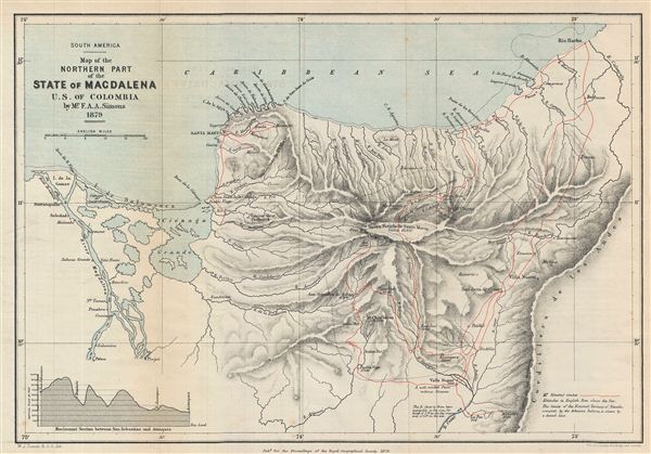
South America. Map of the Northern Part of the State of Magdalena U.S. of Colombia.
1879 (dated) 9 x 13 in (22.86 x 33.02 cm)
1879 (dated) 9 x 13 in (22.86 x 33.02 cm)
Description
This is a fine example of the 1879 Stanford map of northern Magdalena, Colombia. The map covers the northern part of the State of Magdalena (now Department of Magdalena). A horizontal section between San Sebastian and Atanquez is depicted in the bottom left quadrant. Notes the mountainous regions known as Sierra Nevada de Santa Marta and the Island of Salamanca. Also features the Cienaga Grande de Santa Marta, one of the biggest marshes in Colombia, and Santa Marta, capital city of Magdalena. This map was prepared to illustrate the explorations of F. A. A. Simons, a Scottish explorer, whose trek across the Sierra Nevada added considerably to the, at the time, sketchy knowledge of the region. Various towns, cities, rivers, marshes, islands and other topographical details are also noted. This map was drawn by A. K. Johnston and published by e. Stanford with contributions from Mr. F. A. A. Simons, as part of the Proceedings of the Royal Geographical Society and Monthly Record of Geography, Vol. I, in 1879.
CartographerS
Alexander Keith Johnston (December 28, 1804 - July 9, 1871) was a Scottish cartographer and map publisher active in the middle portion of the 19th century. Johnson was born at Kirkhill, near Edinburgh, Scotland. He studied at the University of Edinburgh where he apprenticed as an engraver. Around 1826, in partnership with his brother William, he founded a cartographic printing and engraving firm with the imprint "W. and A. K. Johnston." Johnston made a name for himself in educational geography, publishing numerous maps for use in schools. His brother, William Johnston, eventually left the firm to pursue a career in politics, eventually becoming the Lord Provost of Edinburgh. Alexander's son, who would bear the same name, became a geographer and explorer, suffering an untimely death on the Royal Geographical Society's 1879 expedition to Lake Nyasa. More by this mapmaker...
Edward Stanford (May 27, 1827 - November 3, 1904) was one of the most prolific map publishing firms of the late 19th century. The company began as a partnership in 1848 between the 21 year old Edward Stanford and the established map dealer Trelawney Saunders. By 1853 the partnership had dissolved and Edward Stanford took full control of the business. A subsequent series of expansions and exciting new map issues finally led to the production of Stanford's masterwork, "Stanford's Library Map of London". This map is still available and remains somewhat accurate. At the time of publishing it was hailed by the Royal Geographical Society as "the most perfect map of London that has ever been issued". In 1882 Edward Stanford Sr. passed the firm on to his son, Edward Stanford Jr. who continued in his father's proud tradition. Today the Stanford firm still publishes maps and remains one of the most important and prolific cartographic publishers in the world. Learn More...
Source
Stanford, E. Proceedings of the Royal Geographical Society and Monthly Record of Geography, Vol. 1, 1879.
Condition
Very good. Minor wear and toning on original fold lines