This item has been sold, but you can get on the Waitlist to be notified if another example becomes available, or purchase a digital scan.
1818 Pinkerton Map of Peru
Peru-pinkerton-1818$175.00

Title
Peru.
1818 (undated) 28 x 21 in (71.12 x 53.34 cm)
1818 (undated) 28 x 21 in (71.12 x 53.34 cm)
Description
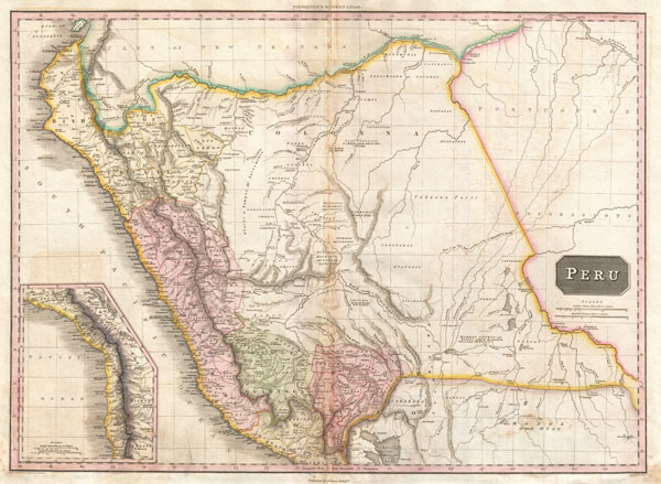
This is John Pinkerton's stunning 1818 map of Peru. Covers the western parts of South America from the Gulf of Guayaquil, in modern Ecuador to Lake Titicaca, modern Peru-Bolivia, and inland well into the Amazon and what is today Brazil. This beautifully rendered map is truly a masterpiece of engraving, with mountain ranges, lakes, deserts, and rivers excited with such precision that the result appears almost three dimensional. Pinkerton injects astounding detail throughout with countless towns, cities, geographical features, rivers, islands and bodies of water noted. This map offers a smorgasbord of speculative cartography - especially in the largely unexplored eastern regions and the Amazon basin. Pinkerton names countless indigenous groups, numerous speculative river systems, questionable mountains and mountain ranges, and a number of notes relating to the supposed discoveries of this or that explorer. The lowlands to the west of the Andes are mapped with considerable precision, contrasting sharply with the less known regions to the east and reflecting some of the challenges in administering Peru's easternmost provinces. One of the finest British atlas maps of Peru to appear in the 19th century.
Drawn by L. Herbert and engraved by Samuel Neele under the direction of John Pinkerton. This map was issued in the scarce American edition of Pinkerton's Modern Atlas, published by Thomas Dobson & Co. of Philadelphia in 1818.
Drawn by L. Herbert and engraved by Samuel Neele under the direction of John Pinkerton. This map was issued in the scarce American edition of Pinkerton's Modern Atlas, published by Thomas Dobson & Co. of Philadelphia in 1818.
CartographerS
John Pinkerton (February 17, 1758 - March 10, 1826) was an Scottish writer, historian, and cartographer. Pinkerton was born in Edinburgh, Scotland. He was a studious youth with a passion for the classics. As a young man, he studied at Edinburgh University before apprenticing as a lawyer. Around this time, he began writing, with his first book, Elegy on Craigmillar Castle published in 1776. Pinkerton moved to London in 1781 to pursue his writing career in earnest. He successfully published several works of literature, poetry, and history. Pinkerton proved passionate in his literary and historical writings, but his correspondence with other cartographers has been labeled as aggressive, even insane. In addition to his work as a writer and historian, Pinkerton was one of the leading masters of the Edinburgh school of cartography which flourished from roughly 1800 to 1830. Pinkerton and his contemporaries (Thomson and Cary) redefined European cartography by abandoning typical 18th century decorative elements such as elaborate title cartouches and fantastical beasts in favor of detail and accuracy. Pinkerton's principle work is Pinkerton's Modern Atlas published from 1808 through 1815 with a special American reissue by Dobson and Co. in 1818. Pinkerton relocated to Paris in 1818, where he managed his publishing business until his death in 1826. More by this mapmaker...
Thomas Dobson (1751 - 1823) was an American publisher active in Philadelphia during the late 18th and early 19th centuries. Dobson was born in Edinburgh, Scotland in 1751 and emigrated to Philadelphia c. 1780. In Philadelphia, he established a successful printing business by republishing edited and updated versions of important British reference materials in matching quality but at a much lower price point. He is best known for publishing the first American edition of the Encyclopedia Britannica. He also published America's first Hebrew Bible. Cartographically Dobson's most notable work is 1818 republication of Pinkerton's fantastic Modern Atlas. Learn More...
Source
Pinkerton, J., A Modern Atlas, from the Lates and Best Authorities, Exhibiting the Various Divisions of the World with its chief Empires, Kingdoms, and States; in Sixty Maps, carefully reduced from the Larges and Most Authentic Sources. 1818, Philadelphia, Thomas Dobson Edition.
Condition
Very good. Minor dampstaining in lower quadrants. Original centerfold. Blank on verso.
References
Rumsey 0732.033 (British edition). Phillips (Atlases) 724. National Maritime Museum, 409. Phillips (America) page 806.