This item has been sold, but you can get on the Waitlist to be notified if another example becomes available, or purchase a digital scan.
1676 John Speed and F. Lamb Map of Virginia and Maryland (Chesapeake Bay)
VirginiaMaryland-johnspeed-1676$3,250.00

Title
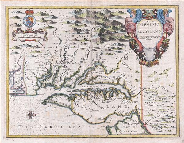
A Map of Virginia and Maryland.
1676 (undated) 14.5 x 19.5 in (36.83 x 49.53 cm)
1676 (undated) 14.5 x 19.5 in (36.83 x 49.53 cm)
Description
A fine full color example of Francis Lamb's 1676 map of Virginia, Maryland, and the Chesapeake Bay. Oriented to the west, Lamb's map covers from Albemarle Sound to the Susquehanna River and from the Appalachian Mountains to the Delaware Bay and New Jersey, inclusive of all of modern day Virginia, Maryland, Delaware, the Chesapeake Bay, and the Delaware Bay. The map notably includes the Chesapeake Bay's western watershed, luring potential colonists with the promise of large navigable rivers and rich fertile lands. The english text on the verso, drawn from Ogilby, further entices with descriptions of Maryland as 'abounding with many fort of fruits and other commodities' and Virginia as 'very wholesome and agreeable to english constitutions.' Indigenous American Indian villages and lands throughout the region are also noted and distinguishable from european cities for the latter being depicted as churches. A fine and large decorative title cartouche of a baroque ethic appears in the upper right quadrant. A secondary cartouche bearing the royal armorial crest of King James II of england hovers over the distance scale in the opposite upper quadrant.
Cartographically Lamb's map is considered by scholars to be the ninth and last derivative of John Smith's 1612 map of the same region. It is therefore of considerable significance. In 1673 Augustine Herman issued his own outstanding map of the Chesapeake and the surrounding colonies. Herman's map was a significant step forward in the cartography of the region and the first major deviation from the Smith map. Subsequent cartography, Lamb's included, struggled to reconcile Smith's established cartography with Hermann's more sophisticated treatment. This map, published just three years following Hermann's map - which exists in only four known examples - is the first widely published map to incorporate the new toponymy and geography, thus bringing an end to the influence of Smith on Virginia / Chesapeake cartography and ushering in a new cartographic era for the region.
This map was published by Thomas Bassett and Richard Chiswell for the 1676 reissue of John Speed's important 1611 atlas, The Theater of the empire of Great Britaine. The Bassett and Chiswell edition of the Theater incorporated a new supplementary section entitled A Prospect of the Most Famous Parts of the World, which included several maps focusing on the english Colonies in the New World. Because it was published in a 'Speed' atlas, this map is often mistakenly attributed to Speed and is commonly referred to as the 'Speed map of Virginia and Maryland.' In fact Speed had been dead some 47 years by the time Bassett and Chiswell hired Francis Lamb to engrave this map.
CartographerS
Francis Lamb (fl. 1667 - 1701) was an English engraver and mapmaker active in London during the second half of the 17th century. Working as an engraver Lamb produced a number of highly influential maps including four plates of the New World for inclusion in the 1676 Basset and Chiswell edition of Speed's "Prospect of the most famous parts of the world". He worked in conjunction many of the most prominent English map publishers of the 17th century including Richard Blome, John Seller, John Ogilby, Robert Morden, William Berry, Moses Pitt, Philip Lea, among others. Little is known of Lamb's personal life however he seems to have been a pupil of the British polymath Robert Hooke, who mentions him regularly in his journals. The dates of Lamb's birth and death are unknown, there is some speculation that he may have died around 1717. Baynton-Williams quotes abundantly with respect to Lamb from Hooke's diary, and the picture is of an exceedingly busy man with connections to many of the best geographical minds of his day. The novel maps he supplied for the 1676 edition of the Speed atlas may well have benefited even more from these connections than from his skill as an engraver. More by this mapmaker...
Thomas Basset (1637 - 1699) and Richard Chiswell (January 4, 1640 - May 3, 1711), publishing as Basset and Chiswell (1675 - 1676), were English booksellers and map publishers active in the latter half of the 17th century. Though both Basset and Chiswell worked independently, their most significant cartographic accomplishment was their joint purchase of John Speed's map plates, from an enigmatic figure known only as Willoughby, in 1675. Basset and Chiswell, working in concert, added and expanded Speed's Theatre of the Empire of Great Britaine, publishing a new and influential edition of the atlas in 1676. Following the publication of the Theatre the partnership dissolved, the Basset and Chiswell imprint appearing on no subsequent maps, and both went on to separate careers. Basset published several other works and ran a bookstore on Fleet Street, London, until declaring bankruptcy in 1696. He died just a few years later in 1699. Chiswell was somewhat more successful, publishing numerous maps and books well into the 1700s. He was praised and admired by his contemporaries; one of whom, John Dunton, writing in 1705 comments that Chiswell "Well deserves the title of Metropolitan Bookseller of England, if not the whole world. His name at the bottom of a title-page does sufficiently recommend the book. He has not been known to print either a bad book, or on a pad paper". Chiswell died on May 3 of 1711 and is commemorated by a monument, erected by his son and still visible in St. Botolph-without-Aldgate Church. Learn More...
John Speed (1542 - 1629) was an important English historian and cartographer active in the early 17th century. Speed was born in Fardon, Cheshire and apprenticed under his father as a tailor. Though his heart was never in tailoring, Speed dedicated himself to this profession until he was about 50 years old. During all the time, Speed dedicated his spare time to research as amateur historian and mapmaker - even preparing several maps for Queen Elizabeth. In London, Speed's interest in history lead him to join the Society of Antiquaries. Eventually he befriended the wealthy Sir Fulke Greville, who sponsored his researches and eventually freed him from the haberdashery profession. Working with William Camden, Speed eventually published his 1611 Historie of Great Britaine. Though this history itself was amateurish and of minimal importance, Speed's inclusion of numerous maps of British Cities and town was seminal. In many cases these plans were the first maps ever issued of their respective subjects. Later, turning his attention more fully to Geography, Speed published the magnificent atlas Theatre of the Empire of Great Britaine and, just prior to his death, the 1627 A Prospect of the Most Famous Parts of the World. These were the first British world atlases and have a landmark position in the history of cartography. These atlases continued to be published well after Speed's death. Learn More...
Source
Speed. J., The Theater of the Empire of Great Britaine, (London) 1676.
Condition
Very good. Original centerfold exhibits light wear. Platemark visible. English text on verso.
References
Burden (America II) no. 456 State 1. illus. plate 456. Tooley, R. V., The Mapping of America, p. 170, derivative 9, State 1. Stephenson, R. W., and McKee, M. M., Virginia in Maps: Four Centuries of Settlement, Growth, and Development, p. 39. Verner, C., 'Smith's Virginia and its Derivatives; a Carto-Bibliographical Study of hte Diffusion of Geographical Knowledge', Map Collectors' Circel, no. 45. Morrison, R., On the Map: An Exhibit and Catalogue of Maps Relating to Maryland and the Chesapeake Bay Honoring George Washington at th Beginning of the Third Century of Washington College at Chestertown, Maryland, p. 17. Baer, E. Notes to Accompany a Facsimile of John Speed's A Map of Virginia and Maryland 1676, no. 86.