This item has been sold, but you can get on the Waitlist to be notified if another example becomes available, or purchase a digital scan.
1818 Pinkerton Map of the Eastern Hemisphere ( Asia , Africa , Europe , Australia)
WorldEH-pinkerton-1818$250.00

Title
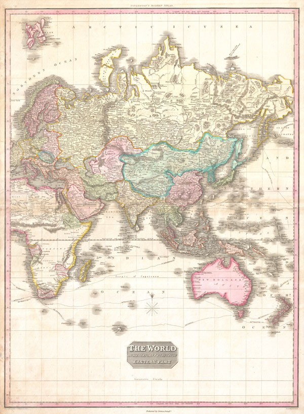
The World on Mercator's Projection Eastern Part.
1818 (undated) 28 x 21 in (71.12 x 53.34 cm)
1818 (undated) 28 x 21 in (71.12 x 53.34 cm)
Description
A rare and important 1818 map of the Eastern Hemisphere by John Pinkerton. Depicts Asia, Europe, Africa and Australia. The routes of various important explores are noted, including Cook, Vancouver, Perouse, and the return route taken by Cook's ship, the Resolution, following his death in Hawaii.
This map offers fairly accurate shorelines throughout. In Africa, the interior remains unexplored except for the Congo, the Cape Colony, the gold mining regions of Monomotapa, and Abyssinia. Similarly, the coasts of Australia are accurate but the interior is vague and unknown. In Asia there are several notations regarding unexplored territories in southwestern China and Central Asia.
Far to the north, in the high Arctic, there is a partial land mass with the note 'Coast discovered by the Hunters employed by m. Liakhov.' This land refers to the Lyakhov Islands, discovered in the 1770s by Russian Fur trader Ivan Lyakhov. These islands, part of New Siberia, were said to have such an abundance of fossilized mammoth ivory that many of the smaller islands were formed from it in their entirety. Lyakhov himself brought back 10,000 tons of Ivory on his first trip and subsequent traders are said to have brought back as much as 100,000 tons in the following 20 years.
Drawn by L. Herbert and engraved by Samuel Neele under the direction of John Pinkerton. The map comes from the scarce American edition of Pinkerton's Modern Atlas, published by Thomas Dobson & Co. of Philadelphia in 1818.
CartographerS
John Pinkerton (February 17, 1758 - March 10, 1826) was an Scottish writer, historian, and cartographer. Pinkerton was born in Edinburgh, Scotland. He was a studious youth with a passion for the classics. As a young man, he studied at Edinburgh University before apprenticing as a lawyer. Around this time, he began writing, with his first book, Elegy on Craigmillar Castle published in 1776. Pinkerton moved to London in 1781 to pursue his writing career in earnest. He successfully published several works of literature, poetry, and history. Pinkerton proved passionate in his literary and historical writings, but his correspondence with other cartographers has been labeled as aggressive, even insane. In addition to his work as a writer and historian, Pinkerton was one of the leading masters of the Edinburgh school of cartography which flourished from roughly 1800 to 1830. Pinkerton and his contemporaries (Thomson and Cary) redefined European cartography by abandoning typical 18th century decorative elements such as elaborate title cartouches and fantastical beasts in favor of detail and accuracy. Pinkerton's principle work is Pinkerton's Modern Atlas published from 1808 through 1815 with a special American reissue by Dobson and Co. in 1818. Pinkerton relocated to Paris in 1818, where he managed his publishing business until his death in 1826. More by this mapmaker...
Thomas Dobson (1751 - 1823) was an American publisher active in Philadelphia during the late 18th and early 19th centuries. Dobson was born in Edinburgh, Scotland in 1751 and emigrated to Philadelphia c. 1780. In Philadelphia, he established a successful printing business by republishing edited and updated versions of important British reference materials in matching quality but at a much lower price point. He is best known for publishing the first American edition of the Encyclopedia Britannica. He also published America's first Hebrew Bible. Cartographically Dobson's most notable work is 1818 republication of Pinkerton's fantastic Modern Atlas. Learn More...
Source
Pinkerton, J., A Modern Atlas, from the Lates and Best Authorities, Exhibiting the Various Divisions of the World with its chief Empires, Kingdoms, and States; in Sixty Maps, carefully reduced from the Larges and Most Authentic Sources. 1818, Philadelphia, Thomas Dobson Edition.
Condition
Very good condition. Minor toning and verso repair on original centerfold. Blank on verso.
References
Rumsey 0732.063. Phillips (Atlases) 724. National Maritime Museum, 409.