
1944 Operation Neptune (D-Day) Manuscript Map Overlays of Normandy, France (Set of 3)

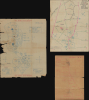
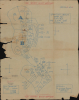
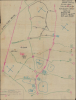
Operations Overlay. Annex No. 1 to F.O. No. 1. HQ-357th Inf. 28 May 1944. / ADM. OVERLAY. France 1:25000 GSGS-4250. NEPTUNE ANNEX#2 TO FO#1 HQ 357th INF, May 28, 1944. / Annex 3a. Overlay to Accompany Intelligence Annex to FO #1 HQ 357th INF. 28 May 1944.
Unique record of D-Day.
$6,000.00
Choose a Collection:
This Item
Enquire
Unique record of D-Day.
This is a collection of three 1944 World War II manuscript map overlays created nine days before the D-Day invasion in Normandy (May 28, 1944), all of which bear the classification BIGOT - TOP SECRET. All three were drawn for the 357th Infantry Regiment, which landed on Utah Beach on June 8, 1944, two days after D-Day. The overlays provide insight into how infantry soldiers prepared and the details these men valued enough to carry into the field. These overlays were found sewn into the collar of a uniform jacket a soldier received in the field.A Closer Look
None of the three overlays label any geographic locations. However, all three identify the corresponding GSGS (Geographical Section, General Staff) map. Two of the overlays are signed by Mason, the S-3 or Operations Officer, and one is signed by Watson, the S-2 or Intelligence Officer. All three are marked as Copy No. 18 of 25, suggesting that 25 sets were made. We have found no indication that any of the others survive.The Maps
- Operations Overlay. Annex No. 1 to F.O. No. 1. HQ-357th Inf. 28 May 1944. The first map in the group is the Operations Overlay. A map reference provided in the lower-left lists four sheets of the France 1:25,000 series, which correspond to the sheets covering the sector that contained Utah Beach, where the Regiment landed on June 8, 1944. The squares are standard military map symbols and indicate where specific units were assigned. For example, the squares with a saltire (a diagonal cross, also known as Saint Andrew's Cross) denote infantry units; the 'Q's indicate quartermaster units; the 'E's indicate engineers; etc. Per the key in the lower right, the circles with 'X's mark the boundaries of defensive sectors assigned to each unit. It is signed by the S-3, or Operations Officer, John H. Mason (see below).
- ADM. OVERLAY. France 1:25000 GSGS-4250. NEPTUNE ANNEX#2 TO FO#1 HQ 357th INF, May 28, 1944. This Administrative Overlay illustrates the 'Corps Circulation Plan', the plan for how the VIII Corps was to use the existing road network inland from the beachheads. The arrows indicate the direction traffic was intended to travel. Areas designated for the Quartermaster, Engineers, Signal Corps, and Medical Corps are marked as well. The pink squares mark Military Police checkpoints. The pink and green lines highlight the Corps Circulation Plan, and the black lines mark the Division Circulation Plan. It is signed by the S-3, or Operations Officer, John H. Mason (see below).
- Annex 3a. Overlay to Accompany Intelligence Annex to FO #1 HQ 357th INF. 28 May 1944. This map is the Intelligence Overlay identifying enemy positions northwest of Utah Beach. It corresponds with GSGS 4250 Sheet 6E/3 and 4 and Sheet 6E/5, which were northwest of Utah Beach along the French coast and slightly inland, including Carentan. The squares along the coast mark German strongpoints (as indicated in the legend at the bottom center). Several German artillery positions are labeled, indicating the number of artillery pieces (4 or 6) and the caliber (105mm or 155mm). An area encircled with a dashed line bears the note, 'Three Co's [companies] Reported in this Area'. A note in the upper-right corner states that 150 artillery and 400 infantry are within the area encircled by the dashed line. The map is signed by the S-2, or Intelligence Officer, whose last name was Watson. We have been unable to trace this individual.
The 357th Infantry Regiment in Normandy
The 357th Infantry Regiment was reactivated on March 25, 1942, and trained in the United States for two years before sailing from New York on March 23, 1944. It arrived in Liverpool on April 4, 1944, where it received additional training. The 357th embarked on two ships on June 4, 1944, and sailed out of Cardiff the next morning. It disembarked off Utah Beach on June 8, 1944 (D+2). The Regiment suffered its first casualties on the morning of June 10 from enemy 88mm artillery fire. The Regiment engaged the enemy at noon on June 10. From Regimental History of the 357th Infantry:World War II had begun in earnest for the new 357th Infantry. The day had been the longest the men had ever spent. The initial shock of seeing old friends struck down had been great, and it was evident that much fierce fighting lay ahead. The hedgerow country of Normandy was nature's gift to defenders.
The 'BIGOT' Acronym
The 'BIGOT' acronym was used in the preparation for the D-Day landings in Normandy to mark information of the highest secrecy, even above Top Secret'. Those with clearance were sometimes referred to as 'BIGOTed'. Per Thomas B. Allen in a 2002 National Geographic article titled 'Untold Stories of D-Day':One simple word, BIGOT, is stamped in big letters across the Operation Neptune Initial Joint Plan of February 12, 1944, and from then until June 6, that stamp appeared on all supremely secret pieces of paper handled by D-Day planners. If any of those papers or maps had fallen into enemy hands, the invasion would have failed or been scuttled - a distinct possibility in the anxious days after Exercise Tiger.
BIGOT was a code word within a code word, a security classification beyond Top Secret. When planners adopted Neptune as the code word for the naval and amphibious aspects of the invasion, they realized that greater protection had to be given to any document or map that even hinted at the time and place of D-Day. They chose the odd code word BIGOT by reversing the letters of two words - To Big- that had been stamped on the papers of officers going to Gibraltar for the invasion of North Africa in November 1942.
The BIGOT maps and documents were created in isolated cocoons of secrecy. One was hidden in Selfridges department store in London. BIGOT workers entered and left Selfridges by a back door, many of them knowing only that they were delivering scraps of information that somehow contributed to the war effort. Others with BIGOT clearances worked on Allied staffs scattered around London and southern England. So restricted was the BIGOT project that when King George visited a command ship and asked what was beyond a curtained compartment, he was politely turned away because, as a sentinel officer later said, 'Nobody told me he was a Bigot.' (Allen, Thomas B., 'Untold Stories of D-Day', National Geographic Magazine June 2002, pp. 2-37).
John H. Mason
Mason was from Los Angeles, California, which we learned from newspaper articles from 1944 and 1945. (During World War II, it was customary for newspaper articles to provide the hometown of any soldier that was quoted in the article.) From the 357th Infantry Regiment's unit history, we know that after arriving in France, Mason took over command of the 3rd Battalion of the 357th Infantry Regiment, and that on February 16, 1945, Mason took over command of the 357th Infantry Regiment, at which point he held the rank of lieutenant colonel.Provenance
These three maps were purchased from the family of Frank DellaVentura, of Plainfield, New Jersey. Frank served in the U.S. Army from December 1942 until January 1946 as an ambulance driver. Having lost his uniform jacket, he applied for and was issued a replacement. That jacket must have belonged to someone who had been wounded or killed, because after a few days of wearing it, he noticed that the collar was stiffer than the collars of other jackets. Upon examination, Frank discovered these three maps wrapped in plastic and sewn into the collar. Thinking them significant, he kept them safe throughout his tour of duty and, after the war, carried them home.Publication History and Census
These three manuscript maps were created on May 28, 1944, nine days before the June 6, 1944, D-Day Landings in Normandy, France. Two are signed by John H. Mason, the Operations Officer (S-3) for the 3rd Battalion, 357th Infantry Regiment, 90th Infantry Division. All three are Copy No. 18 of 25, suggesting that 25 copies of each map were made, likely on May 28, 1944. The fact that all three are Copy No. 18 confirms that these were given to the same soldier (likely an officer). It is possible that more of these 'annexes' were made and that this isn't a complete set, since the last one is Annex 3a, suggesting that there was at least an Annex 3b. We have found no other comparable overlay maps in institutional collections or on the private market.Condition
Fair. Manuscript. All of thin, fragile paper. All have tears and areas of loss. Annex 3a split in half. Operations Overlay measures 24x19 inches. Administrative Overlay measures 21x16 inches. Intelligence Overlay measures 18x12 inches.
References
Van Roeder, G., Regimental History of the 357th Infantry, (Ferdinand Nicki Buchdruckerei) 1945.