
1848 Serrell Large Manuscript Plat Map of 70th to 72nd Streets, West Side of Manhattan

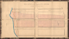
Map of Real Estate in the 12th Ward of the City of New York Belonging to Jacob Harsen, M.D.
Roots of Riverside Park.
- Digital Map Information
- Suitable for large format printing
- DPI: 600
- File Size: 60.66 MB
- File Type: ZIP / TIFF
- ICC color profile embedded
- Delivered instantly via download link
Roots of Riverside Park.
This is a 1848 John J. Serrell large-format manuscript plat map of a portion of the Upper West Side of Manhattan between 70th and 72nd Streets. The map heralds the wholesale transformation of this area in the following decades, from a collection of farms to one of the most desirable residential neighborhoods in New York City.A Closer Look
This map covers an area between 10th Ave. (Amsterdam Ave.) and '12th Ave.' (ghosted in), and between 70th and 72nd Streets on the Upper West Side of Manhattan. Bloomingdale Road (later Broadway) is depicted at right, even though it was, in fact, one of the few features, aside from the farmhouses shaded in dark, that actually existed in this area at the time. Blocks and lots are numbered throughout, with their size noted, along with pencil annotations (some made at a later date).At left, the right-of-way of the Hudson River Railroad (later part of the New York Central) is traced, although the rail line itself was not constructed until the following year, and not opened along its full length until 1851. Though built at-grade, it was replaced by a tunnel in the 1930s (now known as the Freedom Tunnel).
A Home by the Riverside
Perhaps the most interesting feature of this map is the ghosted in projected landfill beyond the Hudson River Railroad up to and extending past 'Twelfth Ave,' right up to the 'exterior line' demarcated by the New York State Legislature in 1857, which prevented any further landfill along the Hudson River. (These annotations must have been added in 1857 or later, well after the map's original production, reflecting its continued use as an important planning document). The development projected here never took place; instead, in the 1860s, the area came to be seen as the ideal location for a 'Riverside Park'. By that time, Central Park had become a major attraction despite not yet being completed and was seen as an engine that could power the relatively moribund urban development of the Upper West Side. Andrew Haswell Green, a leading urban planner and driving force in the Central Park Commission (who frequently clashed with Frederick Law Olmsted and Calvert Vaux), proposed to the New York State Legislature the designation of a waterfront park on the Upper West Side, arguing that no such park existed elsewhere along the Hudson, save Battery Park at the tip of Manhattan.In 1872, lots were acquired, and the following year, Olmsted was chosen to design a park and Riverside Ave. Initially, the avenue was planned to run in a straight line, as the envisioned Twelfth Avenue does here, but that would have required landfill and the construction of a retaining wall, so the avenue instead adopted the somewhat meandering route it follows today. As with Central Park, the construction of Riverside Park led to personality clashes, resulting in Olmsted's ouster, among other issues; however, it was built in the mid-to-late 1870s and opened in 1880. It was immediately hailed for its views of the river and interesting design features, though these were not oddly inconsistent, given the changes in designers and the assignment of different parts of the park to different designers. Ironically, the high price that lots along the park commanded led to relatively slow sales, as the few who could afford them generally preferred the Upper East Side. The presence of the Hudson River Railroad / New York Central (and later the Henry Hudson Parkway) also presented the problem of cutting off the park from the rest of the city. It was only in the early 20th century that apartments along Riverside Drive came to be considered among the most desirable in the city, and the park itself (including a large northwards expansion and the construction of Grant's Tomb) developed to a point that it was regarded as among the city's finest.
The Old Upper West Side
Being among the largest neighborhoods in Manhattan, the Upper West Side even today has a broad scope, encompassing everything between Central Park and the Hudson River. At the time of this map's production, when the area was still largely undeveloped, its reach was arguably even larger. In the early 19th century, although the structure for future urban development theoretically existed within the framework of the Commissioners' Plan of 1811, only a handful of farms, impressive country homes, and small villages appeared sporadically along Bloomingdale Road, which gave its name to the Bloomingdale District (or just Bloomingdale) running all the way from W. 23rd St. (Chelsea) to 125th St. (Harlem). By the mid-19th century, the name Bloomingdale came to refer more specifically to the middle-upper portion of this district, between 96th and 110th Streets, which grew up around manufacturing and shipping along the Hudson River, driven by the construction of the Hudson River Railroad. As a result, and despite its posh reputation today, the Upper West Side was known at the time as something of a rowdy frontier full of squatters, taverns, and a large insane asylum.But the area seen on this map, further south, was part of the distinct village of Harsenville (between 68th and 81st Streets), built on the homestead of the late 18th century settler Jacob Harsen and his wife Catherine Cosine. This land originally was acquired by the Dyckman family in the early 18th century; afterwards, tracing its exact ownership is difficult given the repetition of names (our Jacob had a father and grandson also named Jacob Harsen) and the complex interconnections between the closely-related Dutch settler families of Manhattan (Jacob and Catherine were first cousins). 71st Street was once known as Harsenville Road and was the main means of transportation between the East and West Sides of Manhattan in this area. The large home seen here at right had been that of Cornelius Harsen (1783 - 1838), the only surviving child of Jacob Harsen and Catherine Cosine, who had been a colonel in the War of 1812 (1812 - 1815). During the French Revolution, dozens of noble French refugees settled in Harsenville, changing its character significantly and attracting eminent visitors from the old country, including Talleyrand and General Jean Victor Marie Moreau.
This map was made as even greater changes were beckoning. The city's population was growing, its economy evolving (driven by railroads, among other developments), and its landscape changing, with the earliest concrete discussions of Central Park taking shape around this time. But in subsequent years, the Upper West Side saw a more gradual incorporation into the city's urban sprawl than the Upper East Side. One year after this map's production, eminent domain was used to claim some of the Harsen land to widen Bloomingdale Road, later renamed Broadway, as it had been further south. This also created a triangle of land narrowing to a point between Broadway and Tenth Avenue (at top-right here) that was later dubbed Verdi Square, where a lovely head house was built for the entrance to the 72nd Street Station of the IRT Broadway-Seventh Avenue Line. Still, the Harsenville neighborhood only really developed and filled in the lots laid out here in the late 1870s, after the opening of the Ninth Avenue Elevated (which, despite its name, followed Broadway in this part of Manhattan and was the predecessor to the IRT Broadway-Seventh Avenue Line). The old homesteads were torn down and modern residential buildings (brownstones, largely) were quickly thrown up, leaving little trace of the pre-existing neighborhood.
Publication History and Census
This manuscript map was prepared by City Surveyor John Junius Serrell in November 1848. As a manuscript map, this is an entirely unique work, and like Serrell's other maps, it was surely a key reference for urban planners for decades afterwards. No other maps with this title and scope are known to exist, while the New York Historical (previously known as the New-York Historical Society) holds a large collection of similar Serrell manuscript maps for other parts of the Upper West Side.Cartographer
John Junius Serrell (July 3, 1815 - June 13, 1875) was a prominent surveyor, architect, and civil engineer in New York City in the mid-19th century. Born in London, England, Serrell emigrated with his family to the United States in his childhood. In 1839, he attained a clerkship with the City of New York's Finance Department, where he worked for eight years. Serrell's father, William, opened a civil engineering firm in New York, and John gained an understanding of the profession there. In 1844, he married Mary E. Syms (or Sims, 1822 - 1897), the daughter of a wealthy firearms dealer. (The couple had three sons.) The same year, he was appointed City Surveyor, a position he held for many years, during which he helped plot the city's extension into the Upper West Side, in particular. In 1866, he was appointed Consulting Engineer for Central Park, with a focus on the west side of the park, which had not been developed much at that time. An obituary described him as the 'first topographical engineer of the city' at this time. Unfortunately, at the peak of his prestige, Serrell became incapacitated by an illness. Serrell took a trip to Europe to attempt to regain his health, but to no avail, and after returning, he died in his home in Bayonne, New Jersey, and was buried in Brooklyn's Green-wood Cemetery. Serrell's long career with the city at a time when it was expanding rapidly meant that he produced many maps and surveys that would be consulted for urban planning and legal disputes for decades afterwards.
His brothers, Edward Wellman Serrell (1826 - 1906) and James E. Serrell (1820 - 1892), were also civil engineers, trained by their father and older brother John. Edward became an eminent railroad and bridge engineer and then distinguished himself during the Civil War, forming a volunteer regiment of engineers from New York (which also included James), designing Union fortifications, and building siege equipment (including a massive gun dubbed the 'Swamp Angel') during the siege of Charleston, South Carolina, becoming known after the war as 'the greatest of Civil War engineers.' James Serrell, like his brother John, was a surveyor with the City of New York, initially working with the Street Department. Like John, he had a decades-long career with the city, which included plans for sewers and for grading city streets, in addition to surveys, maps, and engineering plans.
Further Details...
Condition
Average. On original linen. Manuscript pen, wash, pencil. Loss and chipping to edges. Fragile. Could benefit from limited restoration, but presents handsomely as is.
References
Mott, H., The New York of Yesterday: A Descriptive Narrative of Old Bloomingdale, Its Topographical Features, Its Early Families and Their Genealogies...., (Bloomingdale [New York]: Putnam's) 1908.