1945 Harney World War II 84th Infantry Division Route Map of Europe
84thInfantryDiv-harney-1945$550.00

Title
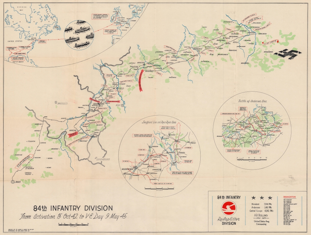
84th Infantry Division From Activation 15 Oct 42 to V-E Day 9 May 45.
1945 (dated) 21.75 x 28 in (55.245 x 71.12 cm) 1 : 1152000
1945 (dated) 21.75 x 28 in (55.245 x 71.12 cm) 1 : 1152000
Description
This is a 1945 George D. Harney World War II 84th Infantry Division route map of Europe. Unlike many maps in the genre, Harney chose to emphasize only the part of the continent where the 84th Infantry Division traveled or saw combat, eliminating most of the geographical context in favor of focusing on those sites where he and his comrades fought. The central map focuses on their movements, while two insets detail actions in specific combat areas.
A Closer Look
Depicting from Paris to the Elbe River, the central map follows the path of the 84th Infantry Division across Europe. Arrows mark movements and combat actions, all of which are dated. These begin with the 'motor march' from Paris to Gulpen in the Netherlands and end with assuming control of the Elbe River Line in mid-April 1945 and connecting with the Russian army on May 2, 1945. Cities, towns, and villages are labeled all along their route, including Geilenkirchen (where the division saw combat for the first time), Koln, Liège, Houffalize, and Hannover. Berlin appears as a destroyed swastika near the right border. Three inset maps focus on aspects of the 84th's service. The first (situated in the upper left corner) illustrates the division's movements from activation on October 15, 1942, through embarkation and the Atlantic crossing, to training in Britain and the channel crossing on November 1 - 4, 1944. The two circular insets in the lower right focus on the Siegfried Line and Roer River Area and the Battle of Ardennes Area, better known today as the Battle of the Bulge. Cities, towns, and villages are marked in each inset, as well as actions taken by the 84th.Engineer Topographic Battalions during World War II
After World War II erupted in Europe, U.S. military officials realized that currently available maps of Europe were inadequate for modern artillery units or even tactical purposes. Their solution was the creation of engineer topographic battalions. Engineer Topographic Battalions provided technical support for the U.S. Army in the form of surveying, drafting, and printing maps for units on the ground. During the war, these battalions were responsible for creating accurate four-color topographic maps, along with surveying, printing, and distribution of these maps.World War II Route Maps
Maps tracing unit movements during World War II were created by both American and British forces during and after the war. As a genre, these maps represent a broad range of aesthetics, from the purely functional that label places and provide dates, to the artistic, even comic. Many combine the three and provide a visually striking but historically informative summary of the unit's peregrinations.Publication History and Census
This map was drafted by George D. Harney and printed by the 663rd Engineer Topographic Company in 1945. We note four cataloged examples which are part of the collections at the University of Wisconsin - Milwaukee, the Wisconsin Veterans Museum Research Center, the University of Louisiana at Monroe, and Texas A and M University.Cartographer
George Daniel (Red) Harney (July 15, 1918 - April 2, 1999) was an American artist, cartographer, and sign maker. Born in Los Angeles, California, Harney worked as a sign painter before being drafted into the U.S. Army on December 22, 1942. He was assigned to the 84th Infantry Division and became a cartographer, making maps for the 84th using aerial reconnaissance photographs. He was also a talented violin player and entertained his comrades with his skill as a musician. Harney served overseas from August 1944 and even found his mother's former home in Germany while there. He also located an uncle still living in Germany who had been imprisoned in a concentration camp 'for a time'. Harney was discharged on January 5, 1946, at the rank of Staff Sergeant, and he returned to making signs in Pomona, California, advertising in his local paper that he was 'Out of the Army - Back on the Job' and 'gold leaf my specialty'. He became a member of the fire department in January 1951. More by this mapmaker...
Condition
Good. Light wear along original fold lines. Verso repairs to separations at fold intersections. Small areas of loss at a few fold intersections. Light toning. Some offsetting.
References
OCLC 183884567.