This item has been sold, but you can get on the Waitlist to be notified if another example becomes available, or purchase a digital scan.
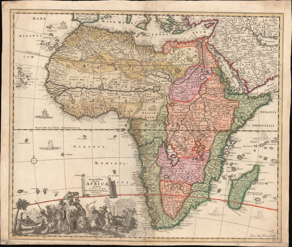
1697 Standrart Map of Africa (one of the first maps engraved by Homann)
AfricaeTabula-sandrart-1697-3$700.00

Title
Accuratissima Totius Africae Tabula in Lucem producta per Iacobum de Sandrart Norimbergae.
1697 (undated) 19.5 x 23 in (49.53 x 58.42 cm) 1 : 19200000
1697 (undated) 19.5 x 23 in (49.53 x 58.42 cm) 1 : 19200000
Description
This is Jacob Sandrart's scarce, separately published 1697 map of Africa. While cartographically derived from Frederic de Wit's influential 1670 Totius Africae Accuratissima Tabula, this map is notable for being the first or second signed engraving by Johann Baptist Homann, the most important German map publisher of the 18th-century. This map's production in 1697 just preceded the opening of Homann's Nuremberg publishing house in 1702.
Following De Wit, the Nile follows the Ptolemaic model, drawing its waters from two great lakes in the southern part of the continent, Zembre (Lake Zaire) and Zaflan.
Rich Detail
This map follows the typical conventions of the period, derived from Frederic de Wit's 1670 Africa map. Here, we can see the sharp contrast between a strong understanding of Africa's coast and a profound ignorance of the interior. On the west coast, several Dutch trading stations, including Fort Nassau and Acara, are noted. In the Atlantic (Oceanus Aethiopicus), the apocryphal island of Nuestra I. de Santa Helena, a common feature of contemporaneous French maps by Sanson and others, is identified.Following De Wit, the Nile follows the Ptolemaic model, drawing its waters from two great lakes in the southern part of the continent, Zembre (Lake Zaire) and Zaflan.
A Fascinating, Bloodthirsty Cartouche
While the body of the map is derivative, the cartouche is a completely unique work, perhaps revealing the self-taught Homann's youthful proclivities as much as his considerable talent. The foreground shows tribal leaders arrayed in opulent splendor while lounging with a lion and what appears to be a fat-tailed sheep while snakes and lizards scurry about. Meanwhile, scimitar-bearing warriors astride Arabian steeds in the background ride down a captive to take his head. Another rider brandishes a severed head. For 17th-century Europeans, the exotic was not merely exciting; it was frightening.Passing the Torch
Mapmaking in the seventeenth century was dominated by publishers in Amsterdam, Paris, and, to a lesser extent, London. The latter part of the century saw a flourishing of the mapmaker's art in Italy, particularly in the work of De Rossi, Cantelli, and the inimitable Vincenzo Coronelli. Nuremberg looms large in printing history for having been home to Schedel's 1493 Liber Chronicarum, but does not appear prominently among map-producing cities until the end of the 16th century with the advent of mapmakers like Sandrart and Pufendorf, finally flourishing under Homann.Publication History and Census
The dating of Sandrart's map is uncertain, as he never produced a formal atlas. His separately published works appeared in composite atlases well into the 18th century, adding to the confusion. Here, we are following Betz, who dates it c. 1697 to correspond with dated examples of Sandrart's other work.CartographerS
Jacob von Sandrart (1630 - 1708) was a German publisher and artist active in Nuremburg in the late 17h century. Sandrart was born in Frankfurt-on-Main but relocated to the publishing center of Nuremberg to study painting under his uncle Joachim von Sandrart and engraving under notated cartographer Cornelius Danckerts. By 1656 he was one of the most responded portraitists and art dealers active in Nuremberg. Sandrart did not produce any known atlases, but he did publish a number of maps, most of which focused on Central Europe. More by this mapmaker...
Johann Baptist Homann (March 20, 1664 - July 1, 1724) was the most prominent and prolific map publisher of the 18th century. Homann was born in Oberkammlach, a small town near Kammlach, Bavaria, Germany. As a young man, Homann studied in a Jesuit school and nursed ambitions of becoming a Dominican priest. Nonetheless, he converted to Protestantism in 1687, when he was 23. It is not clear where he mastered engraving, but we believe it may have been in Amsterdam. Homann's earliest work we have identified is about 1689, and already exhibits a high degree of mastery. Around 1691, Homann moved to Nuremberg and registered as a notary. By this time, he was already making maps, and very good ones at that. He produced a map of the environs of Nürnberg in 1691/92, which suggests he was already a master engraver. Around 1693, Homann briefly relocated to Vienna, where he lived and studied printing and copper plate engraving until 1695. Until 1702, he worked in Nuremberg in the map trade under Jacob von Sandrart (1630 - 1708) and then David Funck (1642 - 1709). Afterward, he returned to Nuremberg, where, in 1702, he founded the commercial publishing firm that would bear his name. In the next five years, Homann produced hundreds of maps and developed a distinctive style characterized by heavy, detailed engraving, elaborate allegorical cartouche work, and vivid hand color. Due to the lower cost of printing in Germany, the Homann firm could undercut the dominant French and Dutch publishing houses while matching their diversity and quality. Despite copious output, Homann did not release his first major atlas until the 33-map Neuer Atlas of 1707, followed by a 60-map edition of 1710. By 1715, Homann's rising star caught the attention of the Holy Roman Emperor Charles VI, who appointed him Imperial Cartographer. In the same year, he was also appointed a member of the Royal Academy of Sciences in Berlin. Homann's prestigious title came with several significant advantages, including access to the most up-to-date cartographic information as well as the 'Privilege'. The Privilege was a type of early copyright offered to very few by the Holy Roman Emperor. Though less sophisticated than modern copyright legislation, the Privilege offered limited protection for several years. Most all J. B. Homann maps printed between 1715 and 1730 bear the inscription 'Cum Priviligio' or some variation. Following Homann's death in 1724, the firm's map plates and management passed to his son, Johann Christoph Homann (1703 - 1730). J. C. Homann, perhaps realizing that he would not long survive his father, stipulated in his will that the company would be inherited by his two head managers, Johann Georg Ebersberger (1695 - 1760) and Johann Michael Franz (1700 - 1761), and that it would publish only under the name 'Homann Heirs'. This designation, in various forms (Homannsche Heirs, Heritiers de Homann, Lat Homannianos Herod, Homannschen Erben, etc.) appears on maps from about 1731 onwards. The firm continued to publish maps in ever-diminishing quantities until the death of its last owner, Christoph Franz Fembo (1781 - 1848). Learn More...
Condition
Very good. Minor repairs to corners and verso reinforcement near the Bight of Biafra (Nigeria).
References
OCLC 159834654, 54620077. Betz, R., The Mapping of Africa A Cartobibliography of Printed Maps of the African Continent to 1700, #165. Norwich, O. I., Norwich's Maps of Africa: An Illustrated and Annotated Cartobibliography, #61. Afriterra, 768.