Digital Image: 1868 Laass Map and View the Waterworks West of Albany, New York
AlbanyWaterworks-laass-1868_d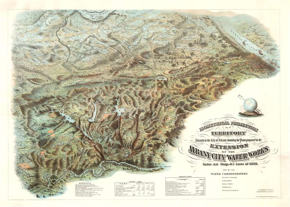

Title
Isometrical Projection of Territory Adjacent to the City of Albany showing the Plans proposed for the Extension of the Albany City Water Works Under Act Chap. 42 Laws of 1868.
1868 (dated) 32.25 x 43.5 in (81.915 x 110.49 cm)
1868 (dated) 32.25 x 43.5 in (81.915 x 110.49 cm)
Description
FOR THE ORIGINAL ANTIQUE MAP, WITH HISTORICAL ANALYSIS, CLICK HERE.
Digital Map Information
Geographicus maintains an archive of high-resolution rare map scans. We scan our maps at 300 DPI or higher, with newer images being 600 DPI, (either TIFF or JPEG, depending on when the scan was done) which is most cases in suitable for enlargement and printing.
Delivery
Once you purchase our digital scan service, you will receive a download link via email - usually within seconds. Digital orders are delivered as ZIP files, an industry standard file compression protocol that any computer should be able to unpack. Some of our files are very large, and can take some time to download. Most files are saved into your computer's 'Downloads' folder. All delivery is electronic. No physical product is shipped.
Credit and Scope of Use
You can use your digial image any way you want! Our digital images are unrestricted by copyright and can be used, modified, and published freely. The textual description that accompanies the original antique map is not included in the sale of digital images and remains protected by copyright. That said, we put significant care and effort into scanning and editing these maps, and we’d appreciate a credit when possible. Should you wish to credit us, please use the following credit line:
Courtesy of Geographicus Rare Antique Maps (https://www.geographicus.com).
How Large Can I Print?
In general, at 300 DPI, you should at least be able to double the size of the actual image, more so with our 600 DPI images. So, if the original was 10 x 12 inches, you can print at 20 x 24 inches, without quality loss. If your display requirements can accommodate some loss in image quality, you can make it even larger. That being said, no quality of scan will allow you to blow up at 10 x 12 inch map to wall size without significant quality loss. For more information, it is best consult a printer or reprographics specialist.
Refunds
If the high resolution image you ordered is unavailable, we will fully refund your purchase. Otherwise, digital images scans are a service, not a tangible product, and cannot be returned or refunded once the download link is used.
Cartographer
Julius Caesar Laass (June 1, 1828 - November 22, 1896) was a German-American civil engineer and draughtsman active in the Albany, New York area in the second half of the 19th century. Laass was born in Sachsen, Germany. He arrived in New York from Hamburg with his brother Leopold, in September of 1847, not exactly a Forty-Eighter, but possibly anticipating the troubles that would erupt just months later. Like many Germans relocating to the United States between 1847 and 1849, Laass was highly educated, a trained engineer, master draughtsman, skilled engraver, and lithographer. He registered for the draft for the American Civil War in 1863, but there is no record he served. After the war, in 1865, he settled in Syracuse, where, working with his brother, the architect Leopold Laass (July 1, 1829 - December 5, 1870), he operated a drafting workshop. A notice in the Syracuse Daily Courier and Union in June of 1865, states that he was in the process of preparing a massive 6.5 x 4.5 foot Bird's Eye View of Syracuse. This ambitious masterpiece was published in 1868 and is one of the most remarkable views ever published. Only a single example, at the Library of Congress, survives. The pursuit of this view underscores the temperament of Laass, a man given to grandiose projects with little prospect of remuneration. A view of this caliber was never before published even for major metropolises, like Boston and New York, mostly because it was not economically viable. Certainly, it was not so with Syracuse. At some point he settled in Albany where he worked for the city. He also issued a view of the 'Greenway’s Brewing and Malting Establishment' of Syracuse, Later in 1868 Laass took work with the State of New York Canal Commission, for home he produced a remarkable chromolithograph view of the lands to the west of Albany. By 1885 he relocated to Marion, Iowa, where he died in 1896. More by this mapmaker...