This item has been sold, but you can get on the Waitlist to be notified if another example becomes available, or purchase a digital scan.
1868 Laass Map and View the Waterworks West of Albany, New York
AlbanyWaterworks-laass-1868$3,000.00

Title
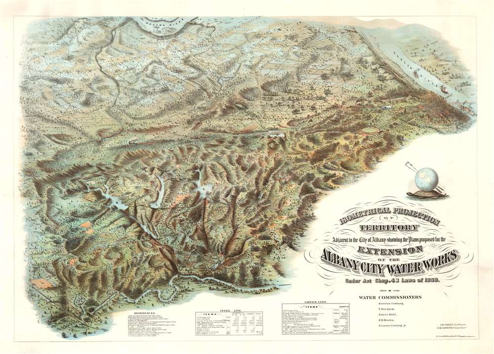
Isometrical Projection of Territory Adjacent to the City of Albany showing the Plans proposed for the Extension of the Albany City Water Works Under Act Chap. 42 Laws of 1868.
1868 (dated) 32.25 x 43.5 in (81.915 x 110.49 cm)
1868 (dated) 32.25 x 43.5 in (81.915 x 110.49 cm)
Description
An oddity the likes of which we have never before seen, this is an innovative and stunning c. 1868 chromolithograph perspective bird's-eye view of the hills and waterworks to the southwest of Albany, New York. The view was drawn by the brilliant and ambitious German-American civil engineer Julius Caesar Laass. While city views were common after the American Civil War, it is unique to discover such a stunning large format chromolithograph illustrating an expansive, largely undeveloped, rural area. This view is thus both unique and innovative in this regard.
The proposed plan, as developed by Albany Waterworks Chief Engineer S. H. Sweet, called for the construction of three new dams: on the east branch of the Hunger Kill, the west branch of the Hunger Hill, and on Kaikout Kill. These would create a trifecta network of reservoirs that would then connect to existing waterworks including the Rensselear Lake Reservoir and the Bleecker Reservoir (currently the site of Bleecker Stadium).
The project was enormous and required correspondingly enormous funds. In addition to state and city provided budgets, it also allowed the city to raise up to 500,000 USD (roughly 10,000,000 USD by today's standards but with far more buying power) from the general public by issuing 'Water Stock of the City of Albany.'
The plan was pursued aggressively from the second half of 1868 into 1869, when, hoping to attract more investors, the city raised the interest rate on the stock from 6 to 7% per annum. It was also around this time that this promotional chromolithograph was issued. Nonetheless, they were unable to garner sufficient support. In 1871, an alternative plan was offered to pump water from the Hudson River, which proved more economical and practical.
Coverage
The view looks northwest on Albany County from a presumptive location far above the Norman Kill. Coverage extends from Albany and the Hudson River southwest as far as French's Mill on the Normankill, roughly in the vicinity of the modern-day Watervliet Reservoir in Guilderland. It further extends northwest to meet the Mohawk River near modern-day Mohawk River Landing Park in Colonie. The view includes a train running on the Hudson River Line and, heading southwest, on part of the now-defunct Hudson-Delaware network.The Waterworks Plan
By the early 1860s Albany had grown such that the existing city waterworks, constructed in 1830, was insufficient to meet demand. An ordinance passed by the State legislature on March 20, 1868, authorized the Albany Common Council to expand the city water supply considerably. Not only did it give the Common Council permission to seize lands under eminent domain, it also provided funding, expansive powers to appropriate public lands, and the right to raise stock.The proposed plan, as developed by Albany Waterworks Chief Engineer S. H. Sweet, called for the construction of three new dams: on the east branch of the Hunger Kill, the west branch of the Hunger Hill, and on Kaikout Kill. These would create a trifecta network of reservoirs that would then connect to existing waterworks including the Rensselear Lake Reservoir and the Bleecker Reservoir (currently the site of Bleecker Stadium).
The project was enormous and required correspondingly enormous funds. In addition to state and city provided budgets, it also allowed the city to raise up to 500,000 USD (roughly 10,000,000 USD by today's standards but with far more buying power) from the general public by issuing 'Water Stock of the City of Albany.'
The plan was pursued aggressively from the second half of 1868 into 1869, when, hoping to attract more investors, the city raised the interest rate on the stock from 6 to 7% per annum. It was also around this time that this promotional chromolithograph was issued. Nonetheless, they were unable to garner sufficient support. In 1871, an alternative plan was offered to pump water from the Hudson River, which proved more economical and practical.
Why So Grand?
The majesty, size, workmanship, quality, and meticulous detail of this chromolithograph are immediately arresting. The quality of the work far exceeds any comparable contemporaneous promotional material. Even views promoting the Brooklyn Bridge pale in comparison. Some insight into this matter may be had by looking at Laass' only other cartographic work, a staggering 6.5 x 4.5 foot Bird's Eye View of Syracuse. The Laass Syracuse view is perhaps the largest and most impressive urban bird's-eye view issued in the 19th century. Laass clearly had a propensity for grandiosity and an obsession with detail that influenced his work irrespective of potential profitability.Turtles all the way down…
The astute will notice the image of the globe resting on the back of a giant world turtle that also serves as a compass rose. The myth of the world turtle or cosmic turtle is best known from Hindu mythology, but the convention is not exclusive to India. The Leni Lenape peoples, an Iroquois nation that occupied the territory between the Delaware and Hudson Rivers, including the lands illustrated here, also had a World Turtle myth. By including the Lenepe world turtle here, Laass ties the land presented to the First Nations peoples who long defined it.Chromolithography
Chromolithography is a color lithographic technique developed in the mid-19th century. The process involved using multiple lithographic stones, one for each color, to yield a rich composite effect. Oftentimes, the process would start with a black basecoat upon which subsequent colors were layered. Some chromolithographs used 30 or more separate lithographic stones to achieve the desired effect. Chromolithograph color could also be effectively blended for even more dramatic results. The process became extremely popular in the late 19th and early 20th centuries, when it emerged as the dominate method of color printing. The vivid color chromolithography produced made it exceptionally effective for advertising and propaganda imagery.Publication History and Census
This present view is the only known example. It was drawn and possibly engraved by Julius Caesar Laass under the auspices of the Albany City Waterworks. It was probably a promotional vehicle for Albany City Water Stock. Although undated, the view must have been produced between 1868 and 1870, when the Albany Common Council was actively promoting the project and can date no later than 1871, when it was abandoned in favor of an alternative water supply from the Hudson River. The fact that no other examples are known, in any archive public or private, suggests this was a proof that never went into full production - a snapshot of a brief grand vision that never met with reality.Cartographer
Julius Caesar Laass (June 1, 1828 - November 22, 1896) was a German-American civil engineer and draughtsman active in the Albany, New York area in the second half of the 19th century. Laass was born in Sachsen, Germany. He arrived in New York from Hamburg with his brother Leopold, in September of 1847, not exactly a Forty-Eighter, but possibly anticipating the troubles that would erupt just months later. Like many Germans relocating to the United States between 1847 and 1849, Laass was highly educated, a trained engineer, master draughtsman, skilled engraver, and lithographer. He registered for the draft for the American Civil War in 1863, but there is no record he served. After the war, in 1865, he settled in Syracuse, where, working with his brother, the architect Leopold Laass (July 1, 1829 - December 5, 1870), he operated a drafting workshop. A notice in the Syracuse Daily Courier and Union in June of 1865, states that he was in the process of preparing a massive 6.5 x 4.5 foot Bird's Eye View of Syracuse. This ambitious masterpiece was published in 1868 and is one of the most remarkable views ever published. Only a single example, at the Library of Congress, survives. The pursuit of this view underscores the temperament of Laass, a man given to grandiose projects with little prospect of remuneration. A view of this caliber was never before published even for major metropolises, like Boston and New York, mostly because it was not economically viable. Certainly, it was not so with Syracuse. At some point he settled in Albany where he worked for the city. He also issued a view of the 'Greenway’s Brewing and Malting Establishment' of Syracuse, Later in 1868 Laass took work with the State of New York Canal Commission, for home he produced a remarkable chromolithograph view of the lands to the west of Albany. By 1885 he relocated to Marion, Iowa, where he died in 1896. More by this mapmaker...
Condition
Very good. Laid down poster-style on linen to stabilize a few closed tears here and there. Fine professional restoration.