1755 Covens and Mortier Map of America w/ Sea of the West
America-covensmortier-1755$1,400.00

Title
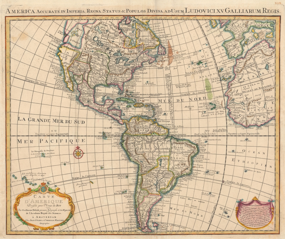
America Accurate in Imperia, Regna, Status and Populos Divisa, ad Usum Ludovici XV, Galliarum Regis. / Carte d'Amerique Dressee pour l'Usage du Roy.
1755 (undated) 20 x 24.5 in (50.8 x 62.23 cm) 1 : 31000000
1755 (undated) 20 x 24.5 in (50.8 x 62.23 cm) 1 : 31000000
Description
An uncommon 1755 variant on Guillaume Delisle's map of America. The map offers much of interest, including theories regarding the Sea of the West, cities of gold in North America, El Dorado, and a magnificent whirlpool in the South Atlantic.
A Closer Look
Coverage encapsulates North and South America, the West Indies, the Atlantic Ocean, and parts of Africa and Europe, including England, Ireland, France, Italy, and Spain. It is no accident that Delisle chose to include these few Western European nations, for his goal was not only to represent the New World, but to express both connection and continuity with the Old World. Delisle includes the Treaty of Tordesillas Line running vertically through the Grand Banks and South America to bring this further into context. This line, drawn in 1494 by Pope Alexandre VI (the map incorrectly states 1493), was intended to divide the New World between Portugal and Spain.An Important Map Updated to Include the Sea of the West
This map was first issued by Delisle in 1722 and quickly became one of the most published maps of the 18th century, passing through numerous states, editions, and piracies. The present example represents the 6th state and a particularly scarce variant, updated to incorporate the Sea of the West - a concept increasingly popular among European positivistic cartographers of the mid-18th century. The Sea of the West is presented as a vast inland body of water, often with islands, situated north of California and west of Lake Winnipeg. It is derived from a combination of wishful thinking, fictitious memoirs, and misinterpretation of factual exploration. As presented here, the Sea of the West extends inland from entrances associated with the Strait of Juan de Fuca and Martin de Aguilar, both factual explorers. Aguilar, sailing in 1682, apparently sited a 'rapid and abundant' river that he could not explore because of the swift current and dangerous entrance. (the Columbia?) Be that as it may, European powers, particularly the English and the French, relished the idea of a large inland sea that would enable them to transport their goods, mostly furs, more easily to the rich markets of Asia. As things stood in the mid-18th century, merchants carrying goods had to either sail around South America, risking pirates or worse, or negotiate with the Spanish, who operated a lucrative trade route through Mexico to Acapulco and thence to Asia.The Kingdoms of Gold
Delisle here even goes so far as to situate the mythical golden city of Quivira on the banks of the Sea - possibly a nod to Aguilar, who was indeed searching for it even though the actual and disappointing Quivira was discovered in 1540 in the Great Plains (near Kansas) by Franciso Vasquez de Coronado. Other mythical western kingdoms are also noted, particularly Teguayo, here spelled Teguaio, situated in a mountain valley northwest of Sante Fe. Teguayo was a speculative golden city first imagined by the missionary Benevides, but popularized a generation later by the Spanish con artist Don Diego Dionisio de Penalosa, who exaggerated the glories of Teguayo to further his political agenda with the Kings of Spain and France.The Laguna de Xarayes
In South America, Delisle maps the Laguna de Xarayes as the source of the Paraguay River. The Xarayes, a corruption of 'Xaraies' meaning 'Masters of the River,' were an indigenous people occupying what are today parts of Brazil's Matte Grosso and the Pantanal. When Spanish and Portuguese explorers first navigated the Paraguay River, as always in search of El Dorado, they encountered the vast Pantanal flood plain at the height of its annual inundation. Understandably misinterpreting the flood plain as a gigantic inland sea, they named it after the local inhabitants, the Xaraies. The Laguna de los Xarayes almost immediately began to appear on early maps of the region and, at the same time, almost immediately took on a legendary aspect. Later missionaries and chroniclers, particularly Díaz de Guzman, imagined an island in this lake and curiously identified it as an 'Island of Paradise,'...an island [of the Paraguay River] more than ten leagues [56 km] long, two or three [11-16 km] wide. A very mild land rich in a thousand types of wild fruit, among them grapes, pears and olives: the Indians created plantations throughout, and throughout the year sow and reap with no difference in winter or summer, ... the Indians of that island are of good will and are friends to the Spaniards; Orejon they call them, and they have their ears pierced with wheels of wood ... which occupy the entire hole. They live in round houses, not as a village, but each apart though keep up with each other in much peace and friendship. They called of old this island Land of Paradise for its abundance and wonderful qualities.To the north of the 'Island of Paradise' appeared the 'Puerto de los Reyes', which was considered a gateway to the Amazon and the Kingdom of El Dorado. D'Anville, to his credit, shows the 'Laguna' and its island in a much-reduced form compared to earlier cartographers and comments that its existence is 'dubious.'
Atlantic Whirlpools
This map also contains many other curious elements, including a maelstrom in the middle of the Atlantic Ocean. We have identified no earlier map than De l'Isle's to show this curious whirlpool; nevertheless, Delisle is unlikely to have imagined it and no doubt drew it from actual mariner's reports. Interestingly, modern scientists have recently identified two massive whirlpools in the South Atlantic. While not permanent, these whirlpools last several months before dissipating. One can only wonder if Delisle discovered 18th-century records of this recently rediscovered phenomenon.Publication History
This map was issued by Covens and Mortier for the 1755 edition of the Atlas Nouveau.CartographerS
Covens and Mortier (1721 - c. 1862) was an Amsterdam publishing firm, the successor to the extensive publishing empire built by Pierre Mortier (1661 - 1711). Covens and Mortier maps are often criticized as derivative - but this is not fully the case. Pierre Mortier lived in Paris from 1681 to 1685. There he established close relationships the the greatest French cartographers of the era, including De L'Isle and D'Anville. His business model was based upon leveraging Dutch printing technology and sophistication to co-publish state of the art French cartography. Upon Mortier's death in 1711 his firm was taken over by his son, Cornelius Mortier (1699 - 1783). Cornelius married the sister of Johannes Covens (1697 - 1774) in 1721 and, partnering with his brother in law, established the Covens and Mortier firm. Under the Covens and Mortier imprint, Cornelius and Johannes continued in Pierre's model of publishing the most up-to-date French works with permission. They quickly became one of the largest and most prolific Dutch publishing concerns of the 18th century. The firm and its successors published thousands of maps over a 120 year period from 1721 to the mid-1800s. During their long lifespan the Covens and Mortier firm published as Covens and Mortier (1721 - 1778), J. Covens and Son (1778 - 94) and Mortier, Covens and Son (1794 - c. 1862). More by this mapmaker...
The De L'Isle family (fl. c. 1700 - c. 1760) (also written Delisle) were, in composite, a mapmaking tour de force who redefined early 18th century European cartography. Claude De L'Isle (1644 -1720), the family patriarch, was Paris based a historian and geographer under Nicholas Sanson. De L'Isle and his sons were proponents of the school of "positive geography" and were definitive figures, defining the heights of the Golden Age of French Cartography. Of his twelve sons, four, Guillaume (1675 - 1726), Simon Claude (1675 - 1726), Joseph Nicholas (1688 - 1768) and Louis (1720 - 1745), made a significant contributions to cartography. Without a doubt Guillaume was the most remarkable member of the family. It is said that Guillaume's skill as a cartographer was so prodigious that he drew his first map at just nine years of age. He was tutored by J. D. Cassini in astronomy, science, mathematics and cartography. By applying these diverse disciplines to the vast stores of information provided by 18th century navigators, Guillaume created the technique that came to be known as "scientific cartography", essentially an extension of Sanson's "positive geography". This revolutionary approach transformed the field of cartography and created a more accurate picture of the world. Among Guillaume's many firsts are the first naming of Texas, the first correct map of the Mississippi, the final rejection of the insular California fallacy, and the first identification of the correct longitudes of America. Stylistically De L'Isle also initiated important changes to the medium, eschewing the flamboyant Dutch style of the previous century in favor of a highly detailed yet still decorative approach that yielded map both beautiful and informative. Guillaume was elected to the French Academie Royale des Sciences at 27. Later, in 1718, he was also appointed "Premier Geographe du Roi", an office created especially for him. De L'Isle personally financed the publication of most of his maps, hoping to make heavy royalties on their sales. Unfortunately he met an untimely death in 1728, leaving considerable debt and an impoverished child and widow. De L'Isle's publishing firm was taken over by his assistant, Phillipe Buache who became, posthumously, his son in law. The other De L'Isle brothers, Joseph Nicholas and Louis De L'Isle, were employed in the Service of Peter the Great of Russia as astronomers and surveyors. They are responsible for cataloguing and compiling the data obtained from Russian expeditions in the Pacific and along the northwest coast of America, including the seminal explorations of Vitus Bering and Aleksei Chirikov. The De L'Isles, like their rivals the Vaugondys , must be considered speculative geographers. Speculative geography was a genre of mapmaking that evolved in Europe, particularly Paris, in the middle to late 18th century. Cartographers in this genre would fill in unknown areas on their maps with speculations based upon their vast knowledge of cartography, personal geographical theories, and often dubious primary source material gathered by explorers and navigators. This approach, which attempted to use the known to validate the unknown, naturally engendered many rivalries. The era of speculatively cartography effectively ended with the late 18th century explorations of Captain Cook, Jean Francois de Galaup de La Perouse, and George Vancouver. Learn More...
Condition
Very good. Original pressmark visible.
References
Tooley, R.V., Mapping of America, page 14, plate 3. Rumsey 4638.092 (1736).