
This item below is out of stock, but another example (left) is available. To view the available item, click "Details."
Details
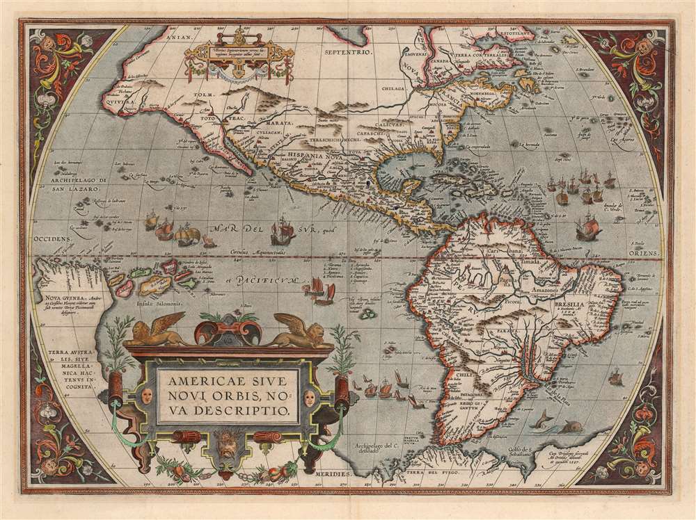
1587 / 1589 Ortelius Map of America (English Colonies in North America)
$5,750.00
1603 Ortelius Map of America
America-ortelius-1587$2,000.00

Title
Americae Sive Novi Orbis Nova Descriptio.
1587 (dated) 14 x 19 in (35.56 x 48.26 cm) 1 : 40000000
1587 (dated) 14 x 19 in (35.56 x 48.26 cm) 1 : 40000000
Description
This is Abraham Ortelius' map of the Western Hemisphere, in an attractive example of the 1587 third state. It represents the state-of-the-art mapping of the Americas during the initial period of European Colonization and the first printed map to illustrate the Chesapeake Bay.
The west coast of North America also has been updated. The place name 'California' is a new addition. B. de los Primeros appears, and, in northern Mexico, Culiacan is newly named. In central Mexico, an entirely new river system appears. Many islands in the Pacific west of California also have been added. In the South Pacific, Ortelius has added the Solomon Islands.
The overall outline of the American continent is otherwise retained. The American Northeast is dominated by Nova Francia and the St. Lawrence, with new data from Cartier's voyages. The Strait of Magellan is shown, though Tierra del Fuego appears not as an island but as part of the speculative southern continent 'Terre Australis' extending all the way to New Guinea. The Pacific Ocean is optimistically narrower than fact, with New Guinea appearing south of Quivira and the strait of Anian.
In Mexico and the Southwest, Coronado's placenames of Cevola (Cibola), Tiguex, and Quivira, all supposed kingdoms of gold, appear.
The First Mapping of the Virginia Colony
Nestled between Nova Francia in the north and La Floridain the south are new details revealing this as the first printed map to show the Chesapeake Bay, predating the 1590 White / De Bry Virginia. This 1587 plate includes an inlet in the vicinity of the actual bay, which does not appear on earlier states of the map. Although the bay is not named, it is accompanied by the newly-applied placename Wingandekoa, which was the Native American word for the territory around the Chesapeake Bay, as reported from Sir Walter Raleigh's 1584 expedition. This knowledge almost certainly reached Ortelius from Jacob Cole, his nephew, who corresponded with his uncle while living in London. The surviving correspondence referred specifically to Wingandekoa.Trimming Patagonia
The most obvious update over the two earlier plates is a correction of the 'Potato-shaped' bulge in the Chilean coast of South America, derived from Mercator's 1569 world map. The resulting, much more recognizable coastline may have been inspired by the report of new Pacific islands off the South American coast, necessitating a reassessment of the coastline. Absent from earlier versions, the third plate includes the islands of St. Nabor (Ambor) and S. Felix, sighted by Juan Férnandez in 1574 (here misdated 1572). It was likely the report of these islands that alerted Ortelius to errors in earlier mappings.The west coast of North America also has been updated. The place name 'California' is a new addition. B. de los Primeros appears, and, in northern Mexico, Culiacan is newly named. In central Mexico, an entirely new river system appears. Many islands in the Pacific west of California also have been added. In the South Pacific, Ortelius has added the Solomon Islands.
The overall outline of the American continent is otherwise retained. The American Northeast is dominated by Nova Francia and the St. Lawrence, with new data from Cartier's voyages. The Strait of Magellan is shown, though Tierra del Fuego appears not as an island but as part of the speculative southern continent 'Terre Australis' extending all the way to New Guinea. The Pacific Ocean is optimistically narrower than fact, with New Guinea appearing south of Quivira and the strait of Anian.
In Mexico and the Southwest, Coronado's placenames of Cevola (Cibola), Tiguex, and Quivira, all supposed kingdoms of gold, appear.
Ortelius' Sources
The number of place names appearing in Spanish suggests the bulk of Ortelius' finer details were derived from Spanish sources - itself a remarkable accomplishment, as the Spanish and Portuguese were famously reticent to publish their discoveries, particularly in the New World. These sources, naturally, are nameless - but the sharp detail of the parts of the Americas within the Spanish sphere gives the game away. The Pacific coast, Mexico, the Caribbean and the Gulf, and South America all reveal detail from a source familiar with the Spanish journeys.Elegant and Distinctive
In addition to the improvements of its geographical detail, the third plate of Ortelius' America benefitted aesthetically as well. Ortelius retained the garlanded, strapwork cartouche of earlier versions, the winged lions, and the vines gracing the corner panels. The stippled oceans, however, are here decorated with flotillas of ships, their profusion indicating the explosion of voyages during the sixteenth century.Publication History and Census
The present third plate of Americae first appeared in the 1587 French edition of the Theatrum, and remained in all subsequent editions. The wording of Ortelius' imprint - 'Ab. Ortelius delineab. Et excudeb. 1587.' - suggests that he engraved the map himself. The verso text conforms to the 1603 Latin edition of the Theatrum Orbis Terrarum. The map appears on the market and is reasonably well represented in institutional collections.CartographerS
Abraham Ortelius (April 14, 1527 - June 28, 1598) also known as Ortels, was a cartographer, geographer, and cosmographer of Brabant, active in Antwerp. He was the creator of the first modern atlas, Theatrum Orbis Terrarum and is a seminal figure in the history of cartography. Along with Gerard Mercator and Gemma Frisius, he was a founder of the Netherlandish school of cartography. His connections with Spain - culminating in his 1575 appointment as Royal Cartographer to King Phillip II of Spain - gave him unmatched access to Spanish geographical knowledge during a crucial period of the Age of Discovery. Ortelius was born in 1527 in Antwerp. In 1547 he entered the Antwerp Guild of Saint Luke as an illuminator of maps. He began trading in books, prints, and maps, traveling regularly to the Frankfurt book and print fair, where in 1554 he met Mercator. He accompanied Mercator on journeys throughout France in 1560 and it was at this time, under Mercator's influence, that he appears to have chosen his career as a scientific geographer. His first published geographic work appeared in 1564, an eight-sheet cordiform world map. A handful of other maps preceded the 1570 publication of the first edition of the Theatrum Orbis Terrarum, which would prove to be his life work. Appearing with but 53 maps in its first edition, Ortelius' work expanded with new maps added regularly. By 1592, it had 134 maps. Many of Ortelius' maps remained the standard for nearly a century. He traveled extensively, but his genius was as a compiler, locating the best informed maps on which to base his own. His contacts throughout Europe and extending even (via the Portuguese) to the Far East were formidable. Moreover, many of his maps were based on his own scholarship, particularly his historical works. His theories of geography were particularly ahead of his time with respect to the notion of continental drift, the possibility of which he mused on as early as 1596, and which would be proven correct centuries later.
In a sense his greatest achievement was his successful navigation of the religious and political violence endemic to his city throughout his adult life: The Dutch Revolt, or Eighty Years' War (1568 - 1648), fully embroiled Antwerp. Although outwardly and officially recognized as Catholic (Arias Montanus vouched for Ortelius' Catholic orthodoxy prior to his appointment as Royal Geographer), Ortelius was able to separate himself from the religious furor which characterized the war in the low countries. Ortelius showed a glimpse of himself in a letter to a friend, regarding humanist Justus Lipsius: 'I do not know whether he is an adherent of the Pope or a Calvinist, but if he has ears to hear, he will neither be one nor the other, for sins are committed on both sides'. Ortelius' own explorations of Biblical history in his maps, and the Christogram contained in his own motto, suggest him to be a religious man, but his abjuration of political religious authorities mark him as an individualist. His tombstone at St Michael's Præmonstratensian Abbey in Antwerp bears the inscription, Quietis cultor sine lite, uxore, prole. ('served quietly, without accusation, wife, and offspring.') More by this mapmaker...
Johannes Baptista Vrients (1552 - 1612) was a Flemish engraver, publisher, and mapseller. Little is known of his early years, but it is to be assumed he came up as an apprentice among the mapmakers of Antwerp, where the guild named him a master in 1575. In the 1590s, he executed world maps for Plancius and Linschoten. (In 1600, after Ortelius died, he became the estate's executor and acquired the plates for the Theatrum.) He would go on to publish further editions of the Ortelius atlas between 1606 and 1612. Vrients also acquired the plates for Gerard De Jode's (1516/17 - 1591) Speculum in and around 1600, but he did not republish that work - though he would preserve the De Jode plates depicting the Electors of the Holy Roman Empire, reprinting it in his editions of the Ortelius atlas after 1603. Most likely, his purchase of the De Jode plates was a play to keep them off the market. Vrients' editions of the Theatrum were not published in Antwerp (that city having fallen during the Dutch war with Spain) but in Amsterdam. Learn More...
Source
Ortelius, Abraham, Theatrum Orbis Terrarum, (Antwerp: Vrients) 1603.
Abraham Ortelius' magnum opus, Theatrum Orbis Terrarum, was the world's first regularly produced atlas, which 'set the standards for later atlases . . . It was the first undertaking of its kind to reduce the best available maps to an uniform format.' (Koeman) A modestly-sized work of fifty-three maps in its first edition of May 1570, it was an immediate success: there were three further editions that year, and the work remained in print for a total of 32 editions, the last of which was 1641, well after its author's 1598 death. Ortelius added to his atlas constantly, and by 1595 the Theatrum contained 147 maps. Ortelius is renowned generally as an editor, and indeed much of the Theatrum is compiled from a variety of sources: in such cases, Ortelius was scrupulous in naming his sources. But Ortelius was also a mapmaker in his own right: many of his maps are a distillation of various sources into his own work, and there were many maps - particularly in his atlas of Biblical and ancient history Parergon - which were entirely Ortelius' work. In his role as an editor, Ortelius followed in the footsteps of Munster, whose Cosmographia was, until Ortelius, the best window on the world for the curious European reader. In terms of the artistry of his maps, Ortelius oversaw the first great flourishing of copperplate engraving in the service of cartography to occur in Northern Europe. Ortelius' work provided the model for the atlases of Mercator, Hondius, Blaeu and all their progeny in the 17th century - many of whom were to produce faithful editions of Ortelius' maps in their own productions.
Condition
Very good. Mended split at bottom centerfold just entering printed area. Faint mat burn, else excellent with fine hand color.
References
OCLC 837663861. Rumsey 10001.065. Van den Broecke, Ort11 Burden, P., The Mapping of North America, 64, State 1. Schwartz, S. and Ehrenberg, R., The Mapping of America, p. 69. Pritchard, M. / Taliaferro, H., Degrees of Latitude, Map 1; Wooldridge, W. , 'Ortelius’s Chesapeake,' The Portolan, Journal of the Washington Map Society, pp. 37-40, Winter 2004.