1739 De l'Isle / Covens and Mortier Map of the Western Hemisphere
Americas-delisle-1739$900.00

Title
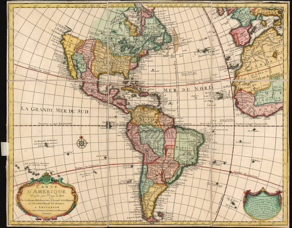
Carte d'Amerique Dressee pour l'Usage du Roy.
1739 (dated) 19 x 23.75 in (48.26 x 60.325 cm) 1 : 31000000
1739 (dated) 19 x 23.75 in (48.26 x 60.325 cm) 1 : 31000000
Description
This is an attractive example of Guillaume De l'Isle's map of America in its first Amsterdam issue. De l'Isle, as Geographer to the King, was considered authoritative throughout Europe, and his maps found an eager audience in Amsterdam and beyond throughout the 18th century.
The American Pacific coast presents California emphatically as part of the mainland - De l'Isle having disavowed an insular California. North of Cap Mendocino is a passage attributed to Martin Aguilar, possibly an early report of the Columbia River. Beyond this, De l'Isle declines to speculate.
In South America, Delisle maps the Laguna de Xarayes as the source of the Paraguay River. The Xarayes, a corruption of 'Xaraies' meaning 'Masters of the River,' were an indigenous people occupying what are today parts of Brazil's Matte Grosso and the Pantanal. When Spanish and Portuguese explorers first navigated up the Paraguay River, as always in search of El Dorado, they encountered the vast Pantanal flood plain at the height of its annual inundation. Understandably misinterpreting the flood plain as a gigantic inland sea, they named it after the local inhabitants, the Xaraies. The Laguna de los Xarayes almost immediately began to appear on early maps of the region and, at the same time, almost immediately took on a legendary aspect. Later missionaries and chroniclers, particularly Díaz de Guzman, imagined an island in this lake and curiously identified it as an 'Island of Paradise.'
A Closer Look
De l'Isle's map covers North and South America, the West Indies, the Atlantic Ocean, and parts of Africa and Europe, including England, Ireland, France, Italy, and Spain. The inclusion of the coasts of the Old World and Africa emphasizes the importance of the Atlantic trade routes. De l'Isle includes the Treaty of Tordesillas Line running vertically through the Grand Banks and South America. This line, drawn in 1494 by Pope Alexandre VI, was intended to divide the New World between Portugal and Spain. Despite the antiquity of that ruling, the line had relevance, at least to explain why Brazil should have been appended to the Portuguese Empire, whilst Newfoundland would pass to the French and the British.The American Pacific coast presents California emphatically as part of the mainland - De l'Isle having disavowed an insular California. North of Cap Mendocino is a passage attributed to Martin Aguilar, possibly an early report of the Columbia River. Beyond this, De l'Isle declines to speculate.
Golden Cities
While De l'Isle was notable for a refusal to present information unsupported by exploration at the limits of his knowledge in the American Northwest, he includes the legendary golden cities of Quivira and Teguaio; the former situated in a mountain valley northwest of Sante Fe, and the latter near the speculative Great River of the West reported by Lahontan.In South America, Delisle maps the Laguna de Xarayes as the source of the Paraguay River. The Xarayes, a corruption of 'Xaraies' meaning 'Masters of the River,' were an indigenous people occupying what are today parts of Brazil's Matte Grosso and the Pantanal. When Spanish and Portuguese explorers first navigated up the Paraguay River, as always in search of El Dorado, they encountered the vast Pantanal flood plain at the height of its annual inundation. Understandably misinterpreting the flood plain as a gigantic inland sea, they named it after the local inhabitants, the Xaraies. The Laguna de los Xarayes almost immediately began to appear on early maps of the region and, at the same time, almost immediately took on a legendary aspect. Later missionaries and chroniclers, particularly Díaz de Guzman, imagined an island in this lake and curiously identified it as an 'Island of Paradise.'
Beware Rocks and Whirlpools
This map also contains a number of navigational threats - predominantly rocks, some of which are noted to lie beneath the ocean surface. Some of these, such as those near Cape Verde marked Abrolhos, derive from Portuguese reports. ('Abrolhos' means 'keep your eyes open.') A notable inclusion is the maelstrom situated in the middle of the Atlantic Ocean. We have identified no earlier map than De l'Isle's to show this curious whirlpool, and De l'Isle's source is obscure; this feature would appear on several other maps during the 18th century in imitation of this map, but by 1800, even De l'Isle's successor Dezauche would be moved to append the word 'doubtful' to this note on his updated version of this map. As it happens, modern scientists have identified two massive whirlpools in the South Atlantic. While not permanent, these whirlpools are known to last several months before dissipating. It may well be that a report of one of these ephemeral wonders had reached De l'Isle's desk.Publication History and Census
Guillaume De l'Isle's map of the Western Hemisphere was long-lived. It first appeared in 1722, printed for De l'Isle in Paris; a second plate was engraved by Covens and Mortier in Amsterdam in 1739, essentially unchanged but with the Covens and Mortier imprint and distinctive, florid lettering for the title's 'd'Amerique.' This plate would be replaced in 1755 to include the novel 'Sea of the West' cartography; further plates would be produced throughout the 18th century. The present example is of the 1739 second plate, making it a comparatively early issue of the map.CartographerS
Guillaume De l’Isle (1675 - 1726) was a French cartographer, and arguably the finest mapmaker at the beginning of the eighteenth century. He was the son of Claude De L'Isle (1644 -1720), a Paris-based historian and geographer under Nicholas Sanson, then the leading light of French cartography. He was the chief proponent of the school of 'positive geography' and the primary figure defining the heights of the Golden Age of French Cartography. Guillaume's skill as a cartographer was so prodigious that he drew his first map at just nine years of age. He was tutored by J. D. Cassini in astronomy, science, mathematics and cartography. By applying these diverse disciplines to the vast stores of information provided by 18th century navigators, Guillaume created the technique that came to be known as 'scientific cartography', essentially an extension of Sanson's 'positive geography'. This revolutionary approach transformed the field of cartography and created a more accurate picture of the world. Among Guillaume's many firsts are the first naming of Texas, the first correct map of the Mississippi, the final rejection of the insular California fallacy, and the first identification of the correct longitudes of America. Stylistically De L'Isle also initiated important changes to the medium, eschewing the flamboyant Dutch style of the previous century in favor of a highly detailed yet still decorative approach that yielded map both beautiful and informative. Guillaume was elected to the French Academie Royale des Sciences at 27. Later, in 1718, he was also appointed 'Premier Geographe du Roi', an office created especially for him. De L'Isle personally financed the publication of most of his maps, hoping to make heavy royalties on their sales. Unfortunately he met an untimely death in 1728, leaving considerable debt and an impoverished child and widow. De L'Isle's publishing firm was taken over by his assistant, Phillipe Buache, who would also become his son in law. More by this mapmaker...
Covens and Mortier (1721 - c. 1862) was an Amsterdam publishing firm, the successor to the extensive publishing empire built by Pierre Mortier (1661 - 1711). Covens and Mortier maps are often criticized as derivative - but this is not fully the case. Pierre Mortier lived in Paris from 1681 to 1685. There he established close relationships the the greatest French cartographers of the era, including De L'Isle and D'Anville. His business model was based upon leveraging Dutch printing technology and sophistication to co-publish state of the art French cartography. Upon Mortier's death in 1711 his firm was taken over by his son, Cornelius Mortier (1699 - 1783). Cornelius married the sister of Johannes Covens (1697 - 1774) in 1721 and, partnering with his brother in law, established the Covens and Mortier firm. Under the Covens and Mortier imprint, Cornelius and Johannes continued in Pierre's model of publishing the most up-to-date French works with permission. They quickly became one of the largest and most prolific Dutch publishing concerns of the 18th century. The firm and its successors published thousands of maps over a 120 year period from 1721 to the mid-1800s. During their long lifespan the Covens and Mortier firm published as Covens and Mortier (1721 - 1778), J. Covens and Son (1778 - 94) and Mortier, Covens and Son (1794 - c. 1862). Learn More...
Condition
Very good. Dissected and mounted on linen for folding. Shelving label appended to left.
References
Tooley, R.V., Mapping of America, page 14, plate 3. Rumsey 4638.092.