1780 Raynal / Bonne Map of Arabia and Abyssinia
Arabie-bonne-1780-2$175.00

Title
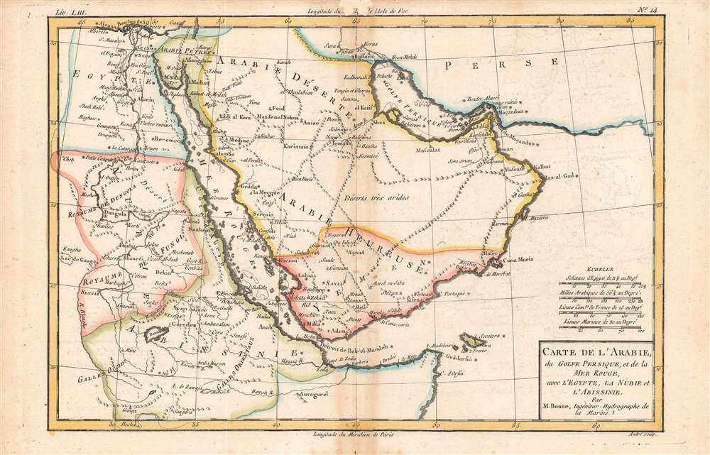
Carte de l'Arabie.
1780 (undated) 8 x 12.25 in (20.32 x 31.115 cm) 1 : 13200000
1780 (undated) 8 x 12.25 in (20.32 x 31.115 cm) 1 : 13200000
Description
This is Rigobert Bonne and Guillaume Raynal's 1780 map of the Arabia and Abyssinia (Ethiopia). It covers from the Nile Delta south as far as the Horn of Africa and west to Persia, fully or partly inclusive of the modern-day countries of Ethiopia, Egypt, Sudan, Eritrea, Djibouti, Somalia, Saudi Arabia, Yemen, Oman, Kuwait, and the United Arab Emirates.
Some of the nomenclature used here requires explanation. The kingdoms of Dungola and Fungl in Nubia refer to Dongola, an ancient religious and commercial center, and the Funj Sultanate or the Sultanate of Sennar, respectively. The Sultanate of Sennar had been the dominant power in Nubia since the 16th century but had declined in power by the time this map was made. In the 19th century, these areas were conquered first by Muhammed Ali Pasha, then by the British. Arabie Pétree, Arabie Déserte, and Arabie Heureuse refer to the Romans' division of the Arabian Peninsula, the first of which was a province of the empire from the 2nd century CE.
A Closer Look
This map offers surprising detail considering that this part of the world was largely unknown to Europeans at the time. Towns, rivers, some topographical features, ports, and political boundaries are identified, while dangerous reefs and other undersea hazards that historically hindered trade in the Red Sea and the Persian Gulf are tentatively ghosted in.Some of the nomenclature used here requires explanation. The kingdoms of Dungola and Fungl in Nubia refer to Dongola, an ancient religious and commercial center, and the Funj Sultanate or the Sultanate of Sennar, respectively. The Sultanate of Sennar had been the dominant power in Nubia since the 16th century but had declined in power by the time this map was made. In the 19th century, these areas were conquered first by Muhammed Ali Pasha, then by the British. Arabie Pétree, Arabie Déserte, and Arabie Heureuse refer to the Romans' division of the Arabian Peninsula, the first of which was a province of the empire from the 2nd century CE.
Publication History and Census
This map was drawn by Bonne for Raynal's Atlas de Toutes les Parties Connues du Globe Terrestre, Dressé pour l'Histoire Philosophique et Politique des Établissemens et du Commerce des Européens dans les Deux Indes. It was engraved by Gaspard André, an individual about whom little is known (not to be confused with the 19th century architect of the same name). Both the map itself and the entire atlas in this edition are held by numerous libraries in North America and Europe.CartographerS
Rigobert Bonne (October 6, 1727 - September 2, 1794) was one of the most important French cartographers of the late 18th century. Bonne was born in Ardennes à Raucourt, France. He taught himself mathematics and by eighteen was a working engineer. During the War of the Austrian Succession (1740 - 1748) he served as a military engineer at Berg-op-Zoom. It the subsequent years Bonne became one of the most respected masters of mathematics, physics, and geography in Paris. In 1773, Bonne succeeded Jacques-Nicolas Bellin as Royal Cartographer to France in the office of the Hydrographer at the Depôt de la Marine. Working in his official capacity, Bonne compiled some of the most detailed and accurate maps of the period - most on an equal-area projection known erroneously as the 'Bonne Projection.' Bonne's work represents an important step in the evolution of the cartographic ideology away from the decorative work of the 17th and early 18th century towards a more scientific and practical aesthetic. While mostly focusing on coastal regions, the work of Bonne is highly regarded for its detail, historical importance, and overall aesthetic appeal. Bonne died of edema in 1794, but his son Charles-Marie Rigobert Bonne continued to publish his work well after his death. More by this mapmaker...
Guillaume Thomas Raynal (April 12, 1711 - March 6, 1796) was a French writer, philosopher, and historian active during the Enlightenment. Raynal was educated as a Jesuit, but left the order for unknown reasons, and moved to Paris where he dedicated himself to the production of a number of minor but popular historical works. Raynal's histories opened doors to elite social and artistic circles where he met and befriended various members of the Philosophe Coteries. Raynal's most important work is generally considered to be a 1770 collaboration with Diderot and others entitled, L'Histoire philosophique et politique des établissements et du commerce des Européens dans les deux Indes. Some of the philosophical ideas developed in the book drew negative attention from the authorities who banned the book and posted a notice for the arrest of its authors. Raynal fled to Berlin and later to St. Petersburg, where he lived for a number of years before returning to France in 1787. Though not a cartographer Raynal's name is often attached to several Atlases by Rigobert Bonne, from whom he composed the text. Learn More...
Source
Raynal, G., Atlas de Toutes les Parties Connues du Globe Terrestre, Dressé pour l'Histoire Philosophique et Politique des Établissemens et du Commerce des Européens dans les Deux Indes, (Paris) 1780.
Condition
Good. Reinstated wormholing at top center, confined to margins.
References
Rumsey 3083.029, OCLC 999690002, 837639452.