Digital Image: 1925 National Geographic Map of the Arctic - signed by Ellsworth!
ArcticEllsworth-natgeo-1925_d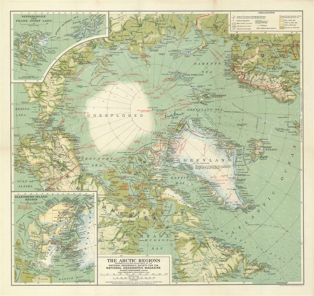

Title
The Arctic Regions.
1925 (dated) 19.5 x 20.5 in (49.53 x 52.07 cm) 1 : 14673400
1925 (dated) 19.5 x 20.5 in (49.53 x 52.07 cm) 1 : 14673400
Description
FOR THE ORIGINAL ANTIQUE MAP, WITH HISTORICAL ANALYSIS, CLICK HERE.
Digital Map Information
Geographicus maintains an archive of high-resolution rare map scans. We scan our maps at 300 DPI or higher, with newer images being 600 DPI, (either TIFF or JPEG, depending on when the scan was done) which is most cases in suitable for enlargement and printing.
Delivery
Once you purchase our digital scan service, you will receive a download link via email - usually within seconds. Digital orders are delivered as ZIP files, an industry standard file compression protocol that any computer should be able to unpack. Some of our files are very large, and can take some time to download. Most files are saved into your computer's 'Downloads' folder. All delivery is electronic. No physical product is shipped.
Credit and Scope of Use
You can use your digial image any way you want! Our digital images are unrestricted by copyright and can be used, modified, and published freely. The textual description that accompanies the original antique map is not included in the sale of digital images and remains protected by copyright. That said, we put significant care and effort into scanning and editing these maps, and we’d appreciate a credit when possible. Should you wish to credit us, please use the following credit line:
Courtesy of Geographicus Rare Antique Maps (https://www.geographicus.com).
How Large Can I Print?
In general, at 300 DPI, you should at least be able to double the size of the actual image, more so with our 600 DPI images. So, if the original was 10 x 12 inches, you can print at 20 x 24 inches, without quality loss. If your display requirements can accommodate some loss in image quality, you can make it even larger. That being said, no quality of scan will allow you to blow up at 10 x 12 inch map to wall size without significant quality loss. For more information, it is best consult a printer or reprographics specialist.
Refunds
If the high resolution image you ordered is unavailable, we will fully refund your purchase. Otherwise, digital images scans are a service, not a tangible product, and cannot be returned or refunded once the download link is used.
Cartographer S
Gilbert Hovey Grosvenor (October 28, 1875 - February 4, 1966) was an American photographer, journalist and editor active in the United States during the first half of the 20th century. Grosvenor was born in Istanbul under the Ottoman empire to American parents living and studying in Istanbul. He studied at the Worchester Academy, the Robert Elementary School, and at Amherst College, where he graduated Magna Cum Laude in 1897. In 1899, shortly after college Grosvenor became the first full time employee of the National Geographic Society - at the time headed by Alexander Graham Bell. In time he became the director, then, in 1920, president of the society. He retained this position, also editing the popular National Geographic Magazine, until 1954. Grosvenor advocated policies of neutrality and positive, upbeat journalism through two world wars, the Great Depression, and the beginning of the Cold War. He laid down the principles of photojournalism, earning the honorific, 'Father of Photojournalism.' He was a champion of the National Park Service, and Katmai National Park's Grosvenor Lodge is named in his honor. Grosvenor was married to Elise May Bell (1878 - 1964), daughter of inventor and National Geographic Society founding father, Alexander Graham Bell. Grosvenor's health deteriorated following the death of his wife and he died peacefully in his sleep at the age of 90 on February 4, 1966. He is interred at Rock Creek Cemetery alongside his wife and other members of the Bell family. More by this mapmaker...
August Hoen and Company (fl. c. 1840 - 1981) was a Baltimore based engraving and lithography firm active in the middle part of the 19th century. A. Hoen and Co. was originally founded by Edward Weber under the name 'E. Weber and Company.' Weber died in the early 1850s and his company was taken over by German immigrant August Hoen (18?? - 1886) and his brothers, Henry and Ernest Hoen. As general interest lithographers, the Hoen firm's corpus includes posters, cigar boxes, sheet music covers, and posters as well as maps. They are best known for their pioneering multi-color lithographic techniques. After the death of August Hoen, the business passed on to his son, Albert Hoen. Another son, Earnest A. Hoen, moved to Richmond, Virginia and opened a branch of the firm there where he was granted a charter to produce Civil War era Confederate Currency. Their contributions to the cartographic field are generally in association with engraving and printing work done for Jacob Monk and the U.S. Geological Survey. The Hoen family maintained an active interest in the firm for the next 100 years or so until it finally filed for bankruptcy in 1981. Learn More...
References
OCLC 494466583.