This item has been sold, but you can get on the Waitlist to be notified if another example becomes available, or purchase a digital scan.
1852 Smith Map of the Arctic showing explorations of Ross, Parry, and Franklin
ArcticExploration-smith-1852$275.00

Title
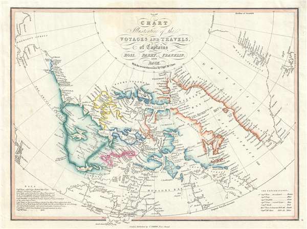
Chart Illustrative of the Voyages and Travels, of Captains Ross, Parry, Franklin, and Back With the recent discoveries by Captn. McClure.
1852 (undated) 10.5 x 14.5 in (26.67 x 36.83 cm)
1852 (undated) 10.5 x 14.5 in (26.67 x 36.83 cm)
Description
A very attractive 1852 map of the North American Arctic by Charles Smith. This map was drawn to capitalize on an era obsessed with the wonders and dangers of Arctic exploration. Covering from Alaska to Iceland and from the North Pole to the Hudson Bay, Smith's map employs color coding to illustrate the discovers of various explorers, including John Ross (Brown), William Parry (Blue), Sir John Franklin (Green), Parry's second voyage (Blue), Sir George Back (Red), Warren Dease and Thomas Simpson (Purple), and Robert McClure (Yellow).
BThe original plate for this map was engraved in 1824 by W. R. Gardner for Smith's New General Atlas. The present example, while still bearing the Smith imprint, drops Gardner's imprint, and has been vastly re-engraved and expanded in coverage to illustrate the 1836-1837 George Back expedition, the 1837-1840 expedition of Peter Warren Dease and Thomas Simpson, as well as the 1850-1852 discoveries of the Robert McClure effort to rescue Franklin.
This map is rare, especially in this present edition. While the 1824 imprint was issued for Smith's New General Atlas, we believe that this, 1852 edition to have been a separate issue, as we are aware of no corresponding edition of the atlas. The OCLC identifies no other examples from this edition, and only 2 examples of earlier editions.
B
This map is rare, especially in this present edition. While the 1824 imprint was issued for Smith's New General Atlas, we believe that this, 1852 edition to have been a separate issue, as we are aware of no corresponding edition of the atlas. The OCLC identifies no other examples from this edition, and only 2 examples of earlier editions.
Cartographer
Charles Smith (1768 - 1854) was 19th century British publisher of maps, atlases, and charts, most of which focused on England and London. Smith was appointed map seller to the Prince of Wales in 1809. His early work stylistically resembles the work of Pinkerton, Cary, and Thomson, though on a much smaller scale. From 1826 to 1854 the business traded as Charles Smith and Son. After Charles Smith's death in 1852 the it was taken over by his son William Smith, and later his grandson Guildford Smith (1838 - 1917), who continued to publish maps well into the 20th century. The younger Smith is best known for his introduction of the 'Tape Indicator Map'. This map, which came with a tape measure, enabled users to triangulate their location based coordinates given in an attached guide. The firm was taken over by George Philip in 1916. More by this mapmaker...
Condition
Very good. Original pressmark visible. Blankn on verso. Rich old color.
References
OCLC 907647918.