Digital Image: 1811 Freycinet Map of Australia
Australia-freycinet-1811_d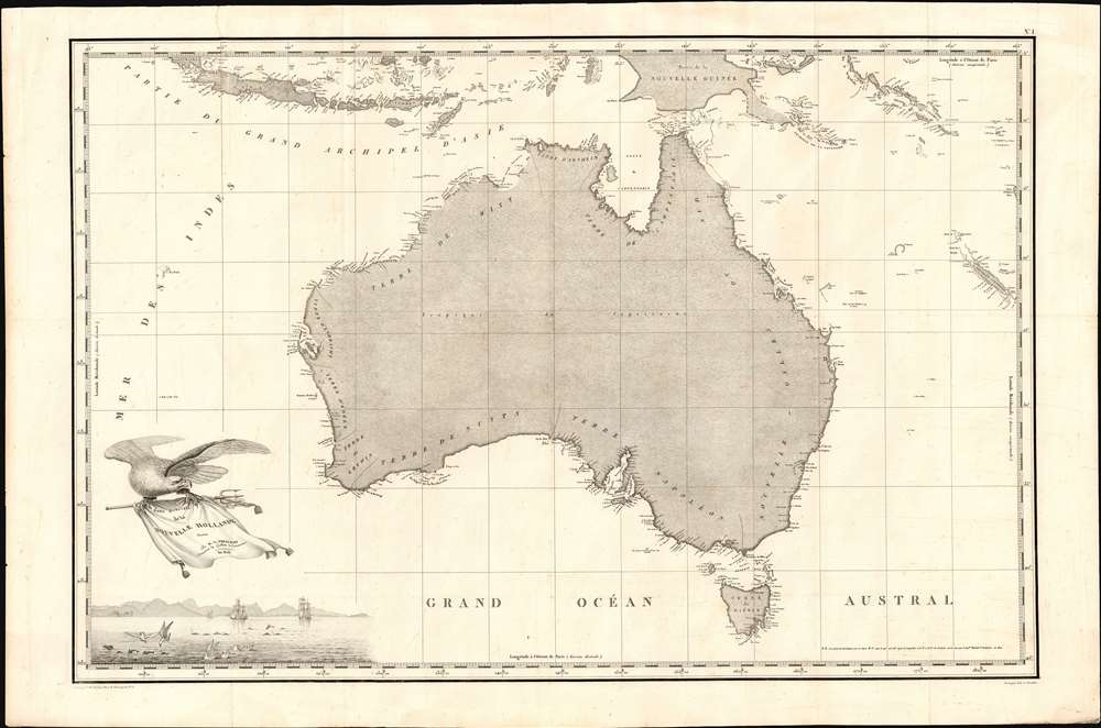

Title
Carte Generale de la Nouvelle Hollande dressee par M L Freycinet Commandant La Goelette, Le Casuarina an 1808.
1811 (dated) 19.75 x 29.5 in (50.165 x 74.93 cm) 1 : 10000000
1811 (dated) 19.75 x 29.5 in (50.165 x 74.93 cm) 1 : 10000000
Description
FOR THE ORIGINAL ANTIQUE MAP, WITH HISTORICAL ANALYSIS, CLICK HERE.
Digital Map Information
Geographicus maintains an archive of high-resolution rare map scans. We scan our maps at 300 DPI or higher, with newer images being 600 DPI, (either TIFF or JPEG, depending on when the scan was done) which is most cases in suitable for enlargement and printing.
Delivery
Once you purchase our digital scan service, you will receive a download link via email - usually within seconds. Digital orders are delivered as ZIP files, an industry standard file compression protocol that any computer should be able to unpack. Some of our files are very large, and can take some time to download. Most files are saved into your computer's 'Downloads' folder. All delivery is electronic. No physical product is shipped.
Credit and Scope of Use
You can use your digial image any way you want! Our digital images are unrestricted by copyright and can be used, modified, and published freely. The textual description that accompanies the original antique map is not included in the sale of digital images and remains protected by copyright. That said, we put significant care and effort into scanning and editing these maps, and we’d appreciate a credit when possible. Should you wish to credit us, please use the following credit line:
Courtesy of Geographicus Rare Antique Maps (https://www.geographicus.com).
How Large Can I Print?
In general, at 300 DPI, you should at least be able to double the size of the actual image, more so with our 600 DPI images. So, if the original was 10 x 12 inches, you can print at 20 x 24 inches, without quality loss. If your display requirements can accommodate some loss in image quality, you can make it even larger. That being said, no quality of scan will allow you to blow up at 10 x 12 inch map to wall size without significant quality loss. For more information, it is best consult a printer or reprographics specialist.
Refunds
If the high resolution image you ordered is unavailable, we will fully refund your purchase. Otherwise, digital images scans are a service, not a tangible product, and cannot be returned or refunded once the download link is used.
Cartographer
Louis Claude de Saulces de Freycinet (August 8 1779 - August 18 1841) was a French Navy officer and circumnavigator. In 1811 he published the first map to show a full outline of the coastline of Australia. Louis-Claude de Saulces de Freycinet joined the French Navy as a midshipman in 1793, and took part in several engagements against the British during the French Revolutionary Wars. In 1800, Freycinet and his brother Louis-Henri were attached to an expedition to Australia under Nicolas Baudin, on the ships Naturaliste and Géographe. Between 1802 1803, Freycinet captained the schooner Casuarina, executing surveys of the Australian coast. He returned to France in 1804. Returning to Paris, he prepared the maps and plans of the expedition, as well as the accompanying narrative, Voyage de découvertes aux terres australes (Paris, 1807–1816). He would later command the corvette Uranie in 1817 in order to make scientific expeditions in Rio de Janeiro and, later, throughout the Pacific - a successful voyage, despite the loss of his ship on his return. Freycinet would be admitted into the French Academy of Sciences in 1825, and was one of the founders of the Paris Geographical Society. More by this mapmaker...
Source
Freycinet, Louis de, Voyage de découvertes aux terres australes/ Atlas. Deuxième partie Langois, Paris 1811
References
OCLC 223110568. Clancy, R. Terra Australis, pp. 137, 140. Tooley (Australia) #610, p. 82.