This item has been sold, but you can get on the Waitlist to be notified if another example becomes available, or purchase a digital scan.
1853 John Capper Map of Australia (Victoria Gold Rush)
Australia-philip-1853$375.00

Title
Australia.
1853 (dated) 20 x 24 in (50.8 x 60.96 cm) 1 : 6869000
1853 (dated) 20 x 24 in (50.8 x 60.96 cm) 1 : 6869000
Description
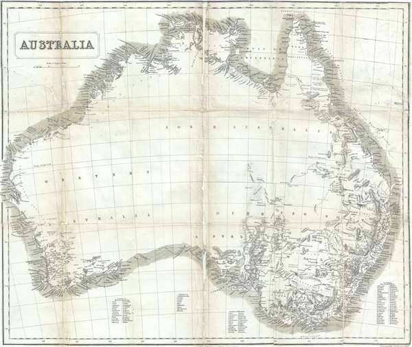
A remarkable 1853 John Capper Map of Australia issued to promote the 1851 Victoria Gold Rush. Capper's map covers the entire continent and offers a wealth of interesting annotations. On the western side of the continent, for example there is annotation that reads, 'coast imperfectly seen through here.' There are is also interesting inland commentary, clearing meant to entice the potential emigrant, such as 'rich grass' and 'low and sandy.' The interior is mostly blank, reflecting the fact that it was largely unexplored at this point, but there are several rivers that are noted in the interior of the continent. Several important gold discoveries are noted.
This map was issued by George Phillip to accompany John Capper's 1853 Emigrant's Guide to Australia. Although extremely rarer today, the Capper Emigrant's Guide was popular in its day, going through at least three editions between 1853 and 1856. The Emigrant's Guide was published for people interested in emigrating to Australia during the 1851 Victoria Gold Rush. Even though this example exhibits condition issues, it would make an incredible addition to any collection focusing on the Australian Gold Rushes. Phillip may also have separately published a version of this map with different border work and minor updates.
This map was issued by George Phillip to accompany John Capper's 1853 Emigrant's Guide to Australia. Although extremely rarer today, the Capper Emigrant's Guide was popular in its day, going through at least three editions between 1853 and 1856. The Emigrant's Guide was published for people interested in emigrating to Australia during the 1851 Victoria Gold Rush. Even though this example exhibits condition issues, it would make an incredible addition to any collection focusing on the Australian Gold Rushes. Phillip may also have separately published a version of this map with different border work and minor updates.
Cartographer
George Philip (1800 - 1882) was a map publisher and cartographer active in the mid to late-19th century. Philip was born into a Calvinst family in Huntly, Aberdeenshire, Scotland. Around 1819 he apprenticed himself to William Grapel, a Liverpool printer and bookseller. Fifteen years later, in 1834, Philip founded his own Liverpool book and map firm. Philip's earliest cartographic ventures were mostly educational material issued in tandem with John Bartholomew Sr., August Petermann, and William Hughes. In 1848, Philip admitted his son, George Philip Jr. (1823 - 1902) into the firm, renaming it George Philip and Son Ltd. George Philip Jr. ran the firm until his death in 1902, by which time it had developed into a major publishing concern. His successors established the London Geographical Institute, a factory where they embraced modern printing techniques to produce thousands of economical and high quality maps. In April 1988, George Philip & Son was acquired by Octopus Publishing, a branch of Reed International. Nonetheless, today the firm trades and publishes to this day as George Philip and Son. More by this mapmaker...
Source
Capper, J., The Emigrant's Guide to Australia, (Liverpool: George Philip) 1853.
Condition
Average. Map has been backed on archival tissue. Exhibits repaired splits on several original fold lines. Several closed and repaired tears from margins. Some loss along original fold lines particularly along the centerfold.
References
OCLC 224613638.