1814 Thomson Map of Australia, New Zealand and New Guinea
Australia-thomson-1814-2$650.00

Title
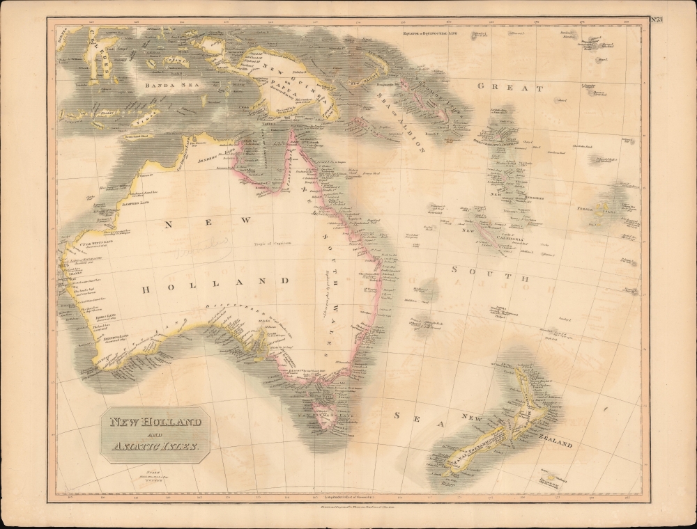
New Holland and Asiatic Isles.
1814 (dated) 20 x 25 in (50.8 x 63.5 cm) 1 : 12000000
1814 (dated) 20 x 25 in (50.8 x 63.5 cm) 1 : 12000000
Description
This a wonderful example of John Thompson's 1814 Map of Australia, New Zealand, New Guinea, and parts of Polynesia.
A Closer Look
Coverage embraces from Western Australia and the Celebes eastward as far as New Caledonia and the Fiji Islands, and southward as far as New Zealand and Chatham Island. This map was prepared around the same time that Captain Flinders published the first accurate map of the Australian coast. Slightly crisper impression in the southeastern portions of Australia, suggests several updates based upon Flinders' work. Inland, Australia, here named 'New Holland' remained a largely unexplored mystery.Publication History and Census
Prepared in 1814 by John Thomson for publication by Baldwin and Cradock in the 1817 edition of Thomson's New General Atlas.CartographerS
John Thomson (1777 - c. 1841) was a Scottish cartographer, publisher, and bookbinder active in Edinburgh during the early part of the 19th century. Thomson apprenticed under Edinburgh bookbinder Robert Alison. After his apprenticeship, he briefly went into business with Abraham Thomson. Later, the two parted ways, John Thomson segueing into maps and Abraham Thomson taking over the bookbinding portion of the business. Thomson is generally one of the leading publishers in the Edinburgh school of cartography, which flourished from roughly 1800 to 1830. Thomson and his contemporaries (Pinkerton and Cary) redefined European cartography by abandoning typical 18th-century decorative elements such as elaborate title cartouches and fantastic beasts in favor of detail and accuracy. Thomson's principle works include Thomson's New General Atlas, published from 1814 to 1821, the New Classical and Historical Atlas of 1829, and his 1830 Atlas of Scotland. The Atlas of Scotland, a work of groundbreaking detail and dedication, would eventually bankrupt the Thomson firm in 1830, at which time their plates were sequestered by the court. The firm partially recovered in the subsequent year, allowing Thomson to reclaim his printing plates in 1831, but filed again for bankruptcy in 1835, at which time most of his printing plates were sold to A. K. Johnston and Company. There is some suggestion that he continued to work as a bookbinder until 1841. Today, Thomson maps are becoming increasingly rare as they are highly admired for their impressive size, vivid hand coloration, and superb detail. More by this mapmaker...
Baldwin and Cradock (fl. c. 1810 - 1860) were London based publishers working in the early to mid 19th century. They are best known for their publication of the Society for the Diffusion of Useful Knowledge's ground breaking subscription atlas. They also published John Thomson's magnificent New General Atlas from 1814 - c. 1820. In addition to their cartographic corpus, the firm had wide ranging publishing interests in many other areas, including books, broadsides, and an investment in Blackwoods Magazine. They had their offices at 47 Paternoster Row, London, England. This firm also published under the imprint Baldwin, Cradock, and Joy and Cradock and Joy. Learn More...
Source
Thomson, J., A New General Atlas, (Edinburgh: Baldwin, Cradock, Joy) 1817.
Thomson's New General Atlas was first published in 1817 and continued to be published until about 1821. This is the first of Thomson's major cartographic works and the atlas for which is most celebrated. The New General Atlas follows in the Edinburgh School, which eschews excessive decoration in favor of a more minimalistic fact-based cartographic vision, as established by John Pinkerton, Laurie and Whittle, John Cary, and others in the previous decades. The maps are notable for their massive scale, heavy stock, elegant color work, and easy-to-read typefaces. Although the atlas stopped being published after 1821, Thomson continued to offer 'supplementary' maps that could be tipped into the atlas as late as 1830, when he declared bankruptcy. The maps in the Thomson Atlas were engraved by Thomas Clerk, William Dassauville, Nathaniel Rogers Hewitt, James Kirkwood, Robert Kirkwood, John Menzies, George Menzies, Edward Mitchell, John Moffatt, Samuel John Neele, Robert Scott, and James Wyld.
Condition
Good. A few minor margin reinforcements and repairs. Some centerfold toning and offsetting.
References
Rumsey 1007.079. Tooley, R.V., Mapping of Australia and Antarctica, p. 156, 1256. Phillips (Atlases) 731. Newberry Library: Ayer +135 T4 1817. National Library of Australia, MAP F 848.