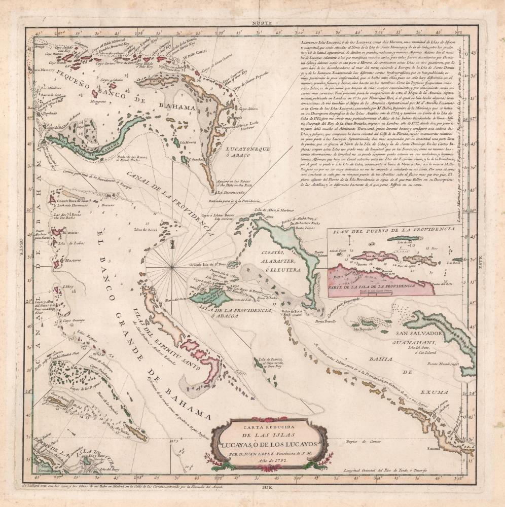
1782 Juan Lopez Map of the Bahamas
Bahamas-lopez-1782$2,200.00

Title
Carta Reducida de la Islas Lucayas, ò de los Lucayos.
1782 (dated) 17 x 17 in (43.18 x 43.18 cm) 1 : 1400000
1782 (dated) 17 x 17 in (43.18 x 43.18 cm) 1 : 1400000
Description
A remarkable 1782 map of the Bahamas by Juan Lopez, son of the famous Spanish geographer Tomás Lopez. The map was issued after shortly after General Bernardo de Gálvez, taking advantage of the chaos of the American Revolutionary War, seized the Bahamas for Spain. Centered on Nassau, coverage extends from the Abaco Islands south to Cuba and east to Exuma and Cat Island. An inset at center right details the vicinity of Nassau.
Historical Context
This map appears at a critical point in Bahaman history. When this map was printed, the Bahamas had just been seized for Spain by Bernardo de Gálvez (1746 - 1786). With this and other victories over the British, Spain believed it was looking forward to a resurgence of Spanish power in the West indies. Nonetheless, at the end of the American Revolution (1775 - 1783), just one year later, displaced loyalists fled the southern colonies en masse. One such, Andrew Deveaux, recaptured Nassau on April 17, 1783. He and other loyalists were intent on establishing a Bahaman plantocracy - a plan that the British government supported by offering land grants throughout the archipelago. The population of the Bahamas tripled within a few years. Loyalists clashed with the existing power structure and their cotton plantations rapidly depleted the archipelago's poor soil. In the end, most returned to England, leaving their abandoned plantations and slaves behind.Sources
This map represents a significant advancement over previous maps of the Bahamas, as well as the best specific map of the Bahamas in the 18th century. In a large text box in the upper left, Lopez describes the history of the archipelago, as well as his sources: Pool (1730), Bellin (1758, 1762 / Carte des Isles Llucayes), and especially Thomas Jeffreys (1777). Although Jefferys did not issue a specific map of the Bahamas, this map combines data from his 1778 Map of the isle of Cuba, with the Bahama Islands and his 1775 Peninsula and Gulf of Florida or Channel of Bahama with the Bahama Islands.Publication History and Census
This map was published by Juan Lopez in 1782. It is extremely rare. We note only one other example entering the private market in the last 20 years. Institutionally, we note examples at the British Library, the Library of Congress, Harvard University, the Biblioteca Nacional de España, and the Bibliothèque nationale de France.Cartographer
Juan Lopez (1765 - 1825) was Spanish cartographer, map publisher, and map dealer active in Spain in the late 18th and early 19th centuries. Juan Lopez is credited with the first printed edition of Barriero’s highly important 1728 manuscript map, considered the first of Texas by a trained surveyor. Although Tooley’s Dictionary of Mapmakers (K-P, p. 155) asserts that Juan Lopez was not the son of great Spanish cartographer, Tomás Lopez (1730 - 1802), other evidence suggests he most certainly was. There are multiple Lopez catalogs issued in the late 18th century that cite both Juan and Tomás Lopez, including the catalog entry for this very map. He became Geógrafo del Rey to Carlos IV in 1795. Lopez continued producing map to about 1820. More by this mapmaker...
Condition
Good. Some edge repairs and soiling. Older framing tape on verso.
References
OCLC 5411883.