1683 Mallet Map of the Bahamas
Bahamas-mallet-1683$300.00

Title
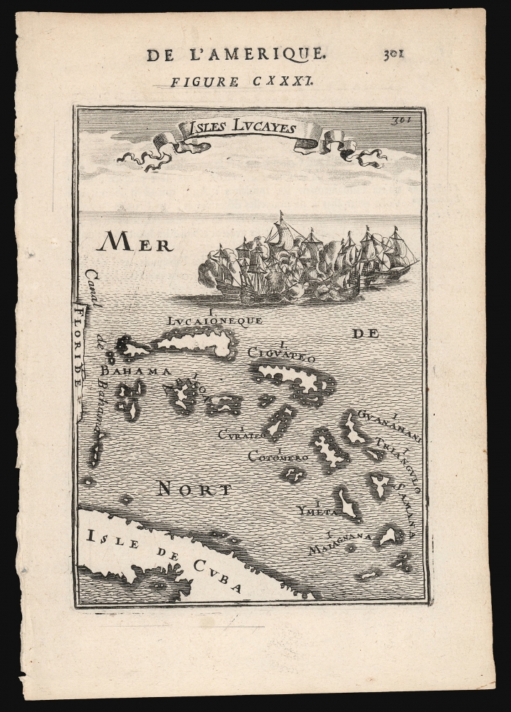
Isles Lucayes.
1683 (undated) 6.5 x 4.25 in (16.51 x 10.795 cm)
1683 (undated) 6.5 x 4.25 in (16.51 x 10.795 cm)
Description
This is a 1683 Alain Manesson Mallet map of the Bahamas: one of the earliest maps to focus on the archipelago. The map pictures the islands separated from Florida by the 'Canal de Bahama', and with part of the island of Cuba marking the map's southern extreme. The islands are presented and named after the c.1631 chart of the Dutch Hessel Gerritsz, whose depiction of the Caribbean provided the main model for the region followed by virtually every cartographer of the 17th century.
The engraving is attractively done: the plate is topped with a flowing title banner, and is decorated with a mighty sea battle: after all, the Canal de Bahama was the safe passage out of the Gulf of Mexico used by the Spanish treasure fleets, and the Bahamas provided Dutch, English and French pirates ample safe harbor in which to lie in wait for the fat Spanish galleons.
The engraving is attractively done: the plate is topped with a flowing title banner, and is decorated with a mighty sea battle: after all, the Canal de Bahama was the safe passage out of the Gulf of Mexico used by the Spanish treasure fleets, and the Bahamas provided Dutch, English and French pirates ample safe harbor in which to lie in wait for the fat Spanish galleons.
Publication History and Census
This map was created by Alain Manesson Mallet and published in the German edition of his work Description de l'univers in 1683. It appears on the market from time to time.CartographerS
Alain Manesson Mallet (1630-1706) was a French cartographer, grammarian, engineer and mathematician, active in the mid to late 17th century. Despite being born in France, as a young man Mallet joined the Portuguese - yes Portuguese - army where he served as a Sergeant-Major. Later he was able to levy his war experience into a career as Inspector of Fortifications for Louis XIV of France. It was in this position, where his work entailed examining and sketching various fortresses, that Mallet developed his cartographic interests. His most important work is his monumental five volume opus Description de L'Univers, published in 1683. This impressive work described the cultures, governments, lands, and customs of all the known peoples of the earth and included numerous maps and engravings. At the time, the Description was the largest and most comprehensive work of its kind ever published. A year later, in 1684, he published his 3 volume Les Travaux de Mars ou l'Art de la Guerre. Mallet is also known for his invention of the "dumpy bubble", a telescopic sight incorporating a level bubble used for surveying and astronomical observations. More by this mapmaker...
Hessel Gerritsz (1581 – September 4, 1632) was a Dutch engraver, cartographer, and publisher active in Amsterdam during the late 16th and early 17th centuries, among the most preeminent Dutch geographers of the 17th century. He was born in Assum, a town in northern Holland in 1581. As a young man he relocated to Alkmaar to accept an apprenticeship with Willem Jansz Blaeu (1571-1638). He followed Blaeu to Amsterdam shortly afterwards. By 1610 he has his own press, but remained close to Blaeu, who published many of his maps. In October of 1617 he was appointed the first official cartographer of the Vereenigde Oost-Indische Compagnie (Dutch East Indian Company) or VOC. This strategic position offered him unprecedented access to the most advanced and far-reaching cartographic data of the Dutch Golden Age. Unlike many cartographers of his period, Gerritsz was more than a simple scholar and showed a true fascination with the world and eagerness to learn more of the world he was mapping in a practical manner. In 1628 he joined a voyage to the New World which resulted in the production of his seminal maps, published by Joannes de Laet in his 1630 Beschrijvinghe van West-Indien; these would be aggressively copied by both the Blaeu and Hondius houses, and long represented the standard followed in the mapping of the new world. Among his other prominent works are a world map of 1612, a 1613 map of Russia by the brilliant Russian prince Fyodor II Borisovich Godunov (1589 – 1605), a 1618 map of the pacific that includes the first mapping of Australia, and an influential 1630 map of Florida. Gerritsz died in 1632. His position with the VOC, along with many of his printing plates, were taken over by Willem Janszoon Blaeu. Learn More...
Source
Mallet, Allain, Description de l'univers, (Paris: Denys) 1683.
Condition
Very good. Marginal mend away from printed image, else excellent.
References
OCLC 767392118.