Digital Image: 1898 Reuterdahl View of the Battle of Santiago de Cuba
BattleSantiago-reuterdahl-1898_d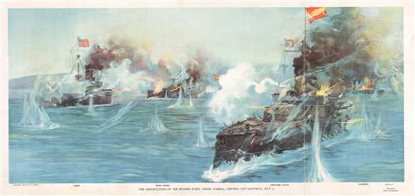

Title
The Destruction of the Spanish Fleet Under Admiral Cervera off Santiago, July 3.
1898 (dated) 10.5 x 22 in (26.67 x 55.88 cm)
1898 (dated) 10.5 x 22 in (26.67 x 55.88 cm)
Description
FOR THE ORIGINAL ANTIQUE MAP, WITH HISTORICAL ANALYSIS, CLICK HERE.
Digital Map Information
Geographicus maintains an archive of high-resolution rare map scans. We scan our maps at 300 DPI or higher, with newer images being 600 DPI, (either TIFF or JPEG, depending on when the scan was done) which is most cases in suitable for enlargement and printing.
Delivery
Once you purchase our digital scan service, you will receive a download link via email - usually within seconds. Digital orders are delivered as ZIP files, an industry standard file compression protocol that any computer should be able to unpack. Some of our files are very large, and can take some time to download. Most files are saved into your computer's 'Downloads' folder. All delivery is electronic. No physical product is shipped.
Credit and Scope of Use
You can use your digial image any way you want! Our digital images are unrestricted by copyright and can be used, modified, and published freely. The textual description that accompanies the original antique map is not included in the sale of digital images and remains protected by copyright. That said, we put significant care and effort into scanning and editing these maps, and we’d appreciate a credit when possible. Should you wish to credit us, please use the following credit line:
Courtesy of Geographicus Rare Antique Maps (https://www.geographicus.com).
How Large Can I Print?
In general, at 300 DPI, you should at least be able to double the size of the actual image, more so with our 600 DPI images. So, if the original was 10 x 12 inches, you can print at 20 x 24 inches, without quality loss. If your display requirements can accommodate some loss in image quality, you can make it even larger. That being said, no quality of scan will allow you to blow up at 10 x 12 inch map to wall size without significant quality loss. For more information, it is best consult a printer or reprographics specialist.
Refunds
If the high resolution image you ordered is unavailable, we will fully refund your purchase. Otherwise, digital images scans are a service, not a tangible product, and cannot be returned or refunded once the download link is used.
Cartographer S
Henry Reuterdahl (1870-1925), a Swedish-American painter, was known for his nautical work and had a strong relationship with the U.S. Navy. He was self-taught, and won a job to be an illustrator-correspondent during the Spanish-American War. He served as a Lieutenant Commander in the U.S. Naval Reserve, and was selected by President Theodore Roosevelt to accompany the Great White Fleet in 1907 to document to voyage. During World War I, he served as head of the poster bureau, and was considered to be America's foremost naval artist. More by this mapmaker...
Peter Fenelon Collier (1849-1909) was an Irish publisher who founded the publishing company P. F. Collier and Son and Collier's Weekly. Collier was born in Ireland and emigrated to the United States at the age of seventeen. Collier's Once a Week was founded in 1888, and by 1892 had a circulation of over 250,000. In 1895, the magazine's name changed to Collier's Weekly: An Illustrated Journal. Learn More...