Digital Image: 1901 Ferguson Map of the Legation Quarter, Beijing (Boxer Rebellion)
BeijingLegationQuarter-ferguson-1901_d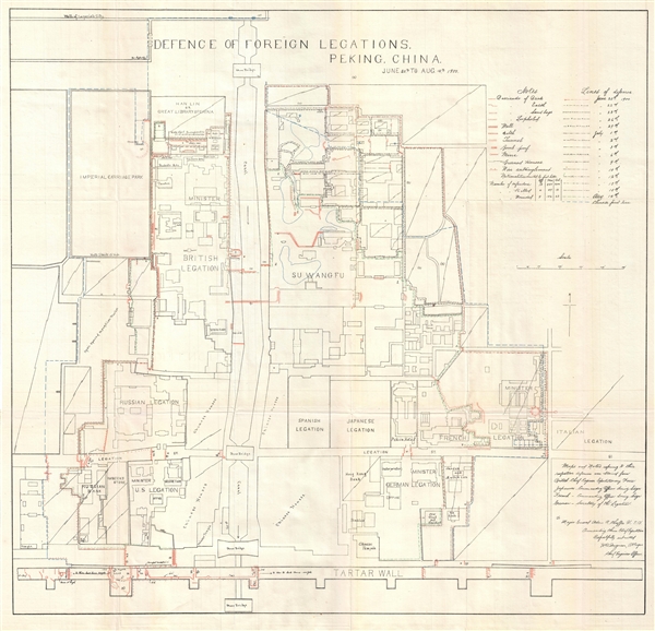

Title
Defence of foreign legations, Peking, China, June 20th to Aug. 14th, 1900.
1900 (dated) 23.6 x 24.5 in (59.944 x 62.23 cm) 1 : 1500
1900 (dated) 23.6 x 24.5 in (59.944 x 62.23 cm) 1 : 1500
Description
FOR THE ORIGINAL ANTIQUE MAP, WITH HISTORICAL ANALYSIS, CLICK HERE.
Digital Map Information
Geographicus maintains an archive of high-resolution rare map scans. We scan our maps at 300 DPI or higher, with newer images being 600 DPI, (either TIFF or JPEG, depending on when the scan was done) which is most cases in suitable for enlargement and printing.
Delivery
Once you purchase our digital scan service, you will receive a download link via email - usually within seconds. Digital orders are delivered as ZIP files, an industry standard file compression protocol that any computer should be able to unpack. Some of our files are very large, and can take some time to download. Most files are saved into your computer's 'Downloads' folder. All delivery is electronic. No physical product is shipped.
Credit and Scope of Use
You can use your digial image any way you want! Our digital images are unrestricted by copyright and can be used, modified, and published freely. The textual description that accompanies the original antique map is not included in the sale of digital images and remains protected by copyright. That said, we put significant care and effort into scanning and editing these maps, and we’d appreciate a credit when possible. Should you wish to credit us, please use the following credit line:
Courtesy of Geographicus Rare Antique Maps (https://www.geographicus.com).
How Large Can I Print?
In general, at 300 DPI, you should at least be able to double the size of the actual image, more so with our 600 DPI images. So, if the original was 10 x 12 inches, you can print at 20 x 24 inches, without quality loss. If your display requirements can accommodate some loss in image quality, you can make it even larger. That being said, no quality of scan will allow you to blow up at 10 x 12 inch map to wall size without significant quality loss. For more information, it is best consult a printer or reprographics specialist.
Refunds
If the high resolution image you ordered is unavailable, we will fully refund your purchase. Otherwise, digital images scans are a service, not a tangible product, and cannot be returned or refunded once the download link is used.
Cartographer
Harley Bascom 'Fergie' Ferguson (August 14, 1875 - August 29, 1968) was an American army officer and engineer active in the late 19th and first half of the 20th century. Ferguson was born in Waynesville, North Carolina, the fourth of seven children. He studied at the U.S. Military Academy at West Point, graduating in 1897. During the Spanish-American War, Ferguson served as a Lieutenant in Santiago, Cuba (1898) and in the Philippines (1899). In 1900, he was sent to Beijing as the Chief Engineer to the China Relief Expedition, a multinational emergency relief effort mustered to suppress the Boxer Rebellion. There he produced the definitive map of the Rebellion and the Defense of the Legation Quarter. From 1910 to 1912, he assisted in raising the U.S.S. Maine in Havana, Cuba. Afterwards he was assigned to various engineering projects in the United States. At the outbreak of World War I, he was sent to France to command the 105th Engineers, 30th Division, American Expeditionary Force. Later in the war he served as the commanding officer of the Port of Debarkation at Newport News, Virginia. Following World War I, he was assigned to various engineering posts related to American waterways. He retired in 1939 as a Major General. A few years later in 1942, he was recalled to duty for World War II, serving, due to advanced age, in command advisory capacity. After retirement, he enjoyed the remainder of this days in Lafayette, Louisiana, where he died at the age of 93. Ferguson’s papers are preserved at the University of North Carolina. More by this mapmaker...
References
OCLC 5482198.