Digital Image: 1749 Bruckner Map of the Bering Strait
BeringStraitIrkucki-bruckner-1749_d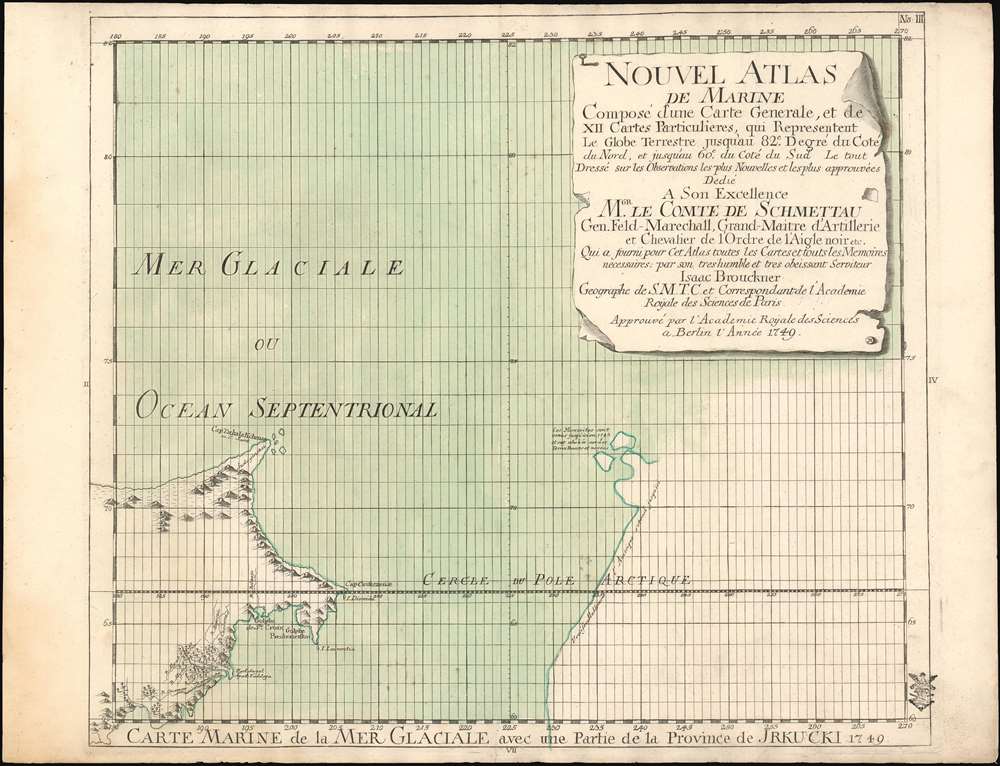

Title
Carte Marine de la Mer Glaciale avec une Partie de la Province de Jrkucki 1749.
1749 (dated) 17.75 x 20.5 in (45.085 x 52.07 cm) 1 : 3100000
1749 (dated) 17.75 x 20.5 in (45.085 x 52.07 cm) 1 : 3100000
Description
FOR THE ORIGINAL ANTIQUE MAP, WITH HISTORICAL ANALYSIS, CLICK HERE.
Digital Map Information
Geographicus maintains an archive of high-resolution rare map scans. We scan our maps at 300 DPI or higher, with newer images being 600 DPI, (either TIFF or JPEG, depending on when the scan was done) which is most cases in suitable for enlargement and printing.
Delivery
Once you purchase our digital scan service, you will receive a download link via email - usually within seconds. Digital orders are delivered as ZIP files, an industry standard file compression protocol that any computer should be able to unpack. Some of our files are very large, and can take some time to download. Most files are saved into your computer's 'Downloads' folder. All delivery is electronic. No physical product is shipped.
Credit and Scope of Use
You can use your digial image any way you want! Our digital images are unrestricted by copyright and can be used, modified, and published freely. The textual description that accompanies the original antique map is not included in the sale of digital images and remains protected by copyright. That said, we put significant care and effort into scanning and editing these maps, and we’d appreciate a credit when possible. Should you wish to credit us, please use the following credit line:
Courtesy of Geographicus Rare Antique Maps (https://www.geographicus.com).
How Large Can I Print?
In general, at 300 DPI, you should at least be able to double the size of the actual image, more so with our 600 DPI images. So, if the original was 10 x 12 inches, you can print at 20 x 24 inches, without quality loss. If your display requirements can accommodate some loss in image quality, you can make it even larger. That being said, no quality of scan will allow you to blow up at 10 x 12 inch map to wall size without significant quality loss. For more information, it is best consult a printer or reprographics specialist.
Refunds
If the high resolution image you ordered is unavailable, we will fully refund your purchase. Otherwise, digital images scans are a service, not a tangible product, and cannot be returned or refunded once the download link is used.
Cartographer S
Isaak Bruckner (July 23 1686 - April 6 1762) was a Swiss buckle maker, stonecutter, machinist and mapmaker. The son of a pastor, he undertook a number of apprenticeships as a clasp and belt maker, a stone cutter and finally as a mechanic. He was accepted into the Basel guild for that trade in 1712. It was this line of work that eventually brought him instrument making, and eventually to mapmaking: In 1722 he constructed his first globe, developing it until 1725. He traveled to Paris in 1725 to present one of his beautiful gilt-copper globes to the Académie des sciences, which was well enough received for him to be appointed a corresponding member of the academy, and to be made a royal geographer to Louis XV. Leonhard Euler invited Bruckner to the Saint Petersburg Academy of Sciences in 1733. There, he taught mechanics and produced instruments and maps, including a sundial (on whose use he also published a pamphlet in 1735). He would leave the Academy in 1745, traveling throughout Europe. He produced his most impressive printed cartographic work in 1749 under the auspices of the Academy of Sciences in Berlin. In 1752 he returned to Basel, to lecture on geography, mechanics and geometry at the University of Basel. In 1754 and 1755 he and his colleague Daniel Bernoulli created a world map and a globe; iterations of the map appeared in Didot's encyclopedia and would be copied by various publishers. More by this mapmaker...
Samuel Graf von Schmettau (March 24, 1684 - August 18, 1751) was a Prussian Field Marshal and cartographer active in the first half of the 18th century. Schmettau was born in London at the Royal Prussian Amtskammerrat the Embassy of influential Hugueont stock. He joined the military at just 15, serving under various flags for various commanding officers, most of whom were his relatives. He saw battle on multiple occasions and rose quickly through the ranks, being made major in 1707 and lieutenant colonel in 1708, and field marshal lieutenant in 1733. In 1741 he was made Imperial Field Marshal, but transferred to the Prussian Army to become instead Prussian Field Marshal. In 1842 he received the Order of the Black Eagle. He was an excellent self-educated cartographer, producing his first map, a detailed survey of Sicily issued in 1723. A plan of Berlin followed in 1748, and a plan of Ostfriesland in 1751. Learn More...
Source
Bruckner, I. Nouvel Atlas de Marine(Berlin,1749)
References
OCLC 956283315. Bagrow, L. History of Russian Cartography up to 1800 pp. 192-194.