1775 / 1787 Sayer / Lemprière Map of Bermuda
Bermuda-sayer-1787$4,000.00

Title
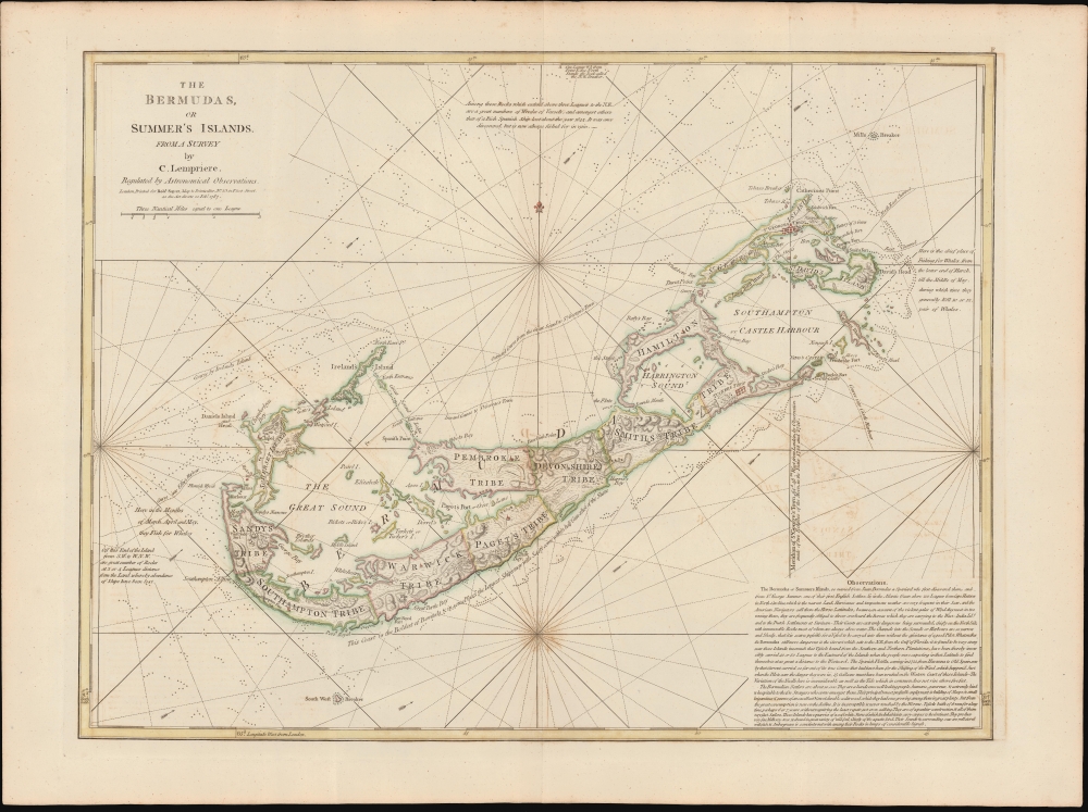
The Bermudas, or Summer's Islands from a Survey by C. Lempriere, regulated by Astronomical Observations.
1787 (dated) 18.25 x 24 in (46.355 x 60.96 cm) 1 : 60000
1787 (dated) 18.25 x 24 in (46.355 x 60.96 cm) 1 : 60000
Description
This is a beautiful example of Robert Sayers' Bermuda, incorporating Clement Lemprière's seminal survey of 1738. Lemprière's survey was the first important mapping of Bermuda in the 18th century, and Sayers' imprint was the first widely available commercial application of that new data.
A Closer Look
Coverage embraces Bermuda and the adjacent seas. The northern-oriented work nests the islands of Bermuda with rhumb lines, but it is not only a sea chart: in addition to the copious nautical details of shoals and reefs, Sayer features detailed topography, roads, and settlements.'Tribes' of Bermuda
As with a number of its precursor maps, this work displays the administrative zones of Bermuda termed 'Tribes.' The Somers Isles company was founded by the shareholders of the Virginia Company formed in 1614. When the Virginia company folded in 1622, Somers Isles Company, which held a separate charter, continued to administer Bermuda for nearly six decades. Most of Bermuda was subdivided into eight equally sized administrative zones initially termed 'tribes,' later changed to 'parishes.' These were named for shareholders in the Company and were further divided (by tribe roads) into lots equating to shares held. Saint George formed a ninth subdivision, now the easternmost parish, incorporating Saint George's Island, Saint David's Island, part of the Main Island, and various smaller islands and islets around Castle Harbour (Southampton Harbour) and Saint George's Harbour. This area was held in common by the Company shareholders and served as Bermuda's original capital, Saint George's Town. While Saint George Harbour was easily accessed by maritime merchants, the location of the capital made it difficult to administer the western reaches of the island, where smugglers and pirates were most active.Bermuda, a haven for smugglers
Lemprière was probably contracted by the governor of Bermuda to create a map of the island in an attempt to curb smuggling. By the 18th century, Bermuda had become a mecca for smugglers. The small archipelago was conveniently located on the trade route between the West Indies and Europe. Free traders, pirates, and smugglers from all countries could conceal themselves in Bermuda's many hidden coves and bays and conduct trade without paying the onerous East India Company tax. They could also use the hidden coves to trade with foreign nations under British embargo. The colonial governors tried in vain to stop the rampant smuggling, but with only a small military staff and a host of corrupt officials, the effort proved hopeless.Publication History and Census
This chart was engraved for Robert Sayer in 1775, for inclusion in Thomas Jeffreys' West-India Atlas; the present example is the second, 1787 state, distinguished by the changed date in the imprint the plate. A further, Laurie and Whittle appeared in 1797 following their takeover of Sayers' firm. Separate examples of the chart appear in a handful of institutional collections. It is rare on the market in any state.CartographerS
Clement Lemprière (January 28, 1682 - July 9, 1746) was a Jerseyman sea captain, military engineer, cartographer, hydrographer, artist, and engraver active in the first half of the 18th century. Of note, most records suggest that Lemprière was born in 1683, but there can be no doubt that his birth was in 1682, as we have found his original baptismal records. We can only assume that 1683 was a transcription error that was subsequently copied by others. Lemprière was born on the isle of Jersey in the town of St. Helier. Little is known of his early life or education, but befitting the life of a sea captain, he was well traveled. There are unverified reports that he was a resident cartographer in charge of the Dawning Room at the Tower of London in 1725 and possibly a drawing tutor to Queen Anne. He is noted for drafting Henry Popple's important map of North America. He may have traveled to Bermuda sometime in the 1730s, as his name is attached to a landmark mapping of that archipelago, the first new map of Bermuda since the Nelson survey of 1660. By the 1740s he was in the British Army, where he was attached to the Engineering Corps. In 1741, he was appointed Chief Draughtsman of the Ordnance Office. His most acclaimed work is a set of sixteen sketches for the eleven tapestries of the Spanish Armada that once hung in the British Parliament. When the Parliament house burnt in 1834, the original tapestries were lost, leaving Lemprière's draft sketches as their only surviving record. More by this mapmaker...
Robert Sayer (1725 - January 29, 1794) was an important English map publisher and engraver active from the mid to late 18th century. Sayer was born in Sunderland, England, in 1725. He may have clerked as a young man with the Bank of England, but this is unclear. His brother, James Sayer, married Mary Overton, daughter-in-law of John Overton and widow of Philip Overton. Sayer initially worked under Mary Overton, but by December of 1748 was managing the Overton enterprise and gradually took it over, transitioning the plates to his own name. When Thomas Jefferys went bankrupt in 1766, Sayer offered financial assistance to help him stay in business and, in this way, acquired rights to many of the important Jefferys map plates as well as his unpublished research. From about 1774, he began publishing with his apprentice, John Bennett (fl. 1770 - 1784), as Sayer and Bennett, but the partnership was not formalized until 1777. Bennett retired in 1784 following a mental collapse and the imprint reverted to Robert Sayer. From 1790, Sayer added Robert Laurie and James Whittle to his enterprise, renaming the firm Robert Sayer and Company. Ultimately, Laurie and Whittle partnered to take over his firm. Sayer retired to Bath, where, after a long illness, he died. During most of his career, Sayer was based at 53 Fleet Street, London. His work is particularly significant for its publication of many British maps relating to the American Revolutionary War. Unlike many map makers of his generation, Sayer was a good businessman and left a personal fortune and great estate to his son, James Sayer, who never worked in the publishing business. Learn More...
Condition
Excellent. Few minor scuffs not impacting printed image. Else an excellent example with generous margins and attractive hand color.
References
Rumsey 4723.006.