Digital Image: 1775 / 1787 Sayer / Lemprière Map of Bermuda
Bermuda-sayer-1787_d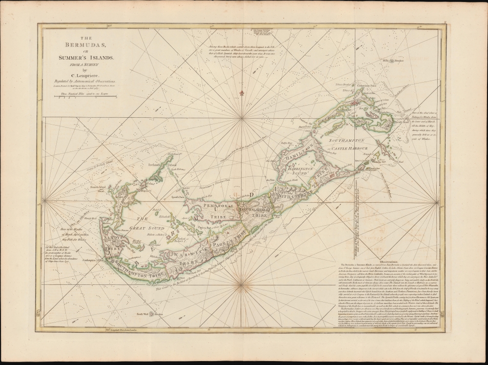

Title
The Bermudas, or Summer's Islands from a Survey by C. Lempriere, regulated by Astronomical Observations.
1787 (dated) 18.25 x 24 in (46.355 x 60.96 cm) 1 : 60000
1787 (dated) 18.25 x 24 in (46.355 x 60.96 cm) 1 : 60000
Description
FOR THE ORIGINAL ANTIQUE MAP, WITH HISTORICAL ANALYSIS, CLICK HERE.
Digital Map Information
Geographicus maintains an archive of high-resolution rare map scans. We scan our maps at 300 DPI or higher, with newer images being 600 DPI, (either TIFF or JPEG, depending on when the scan was done) which is most cases in suitable for enlargement and printing.
Delivery
Once you purchase our digital scan service, you will receive a download link via email - usually within seconds. Digital orders are delivered as ZIP files, an industry standard file compression protocol that any computer should be able to unpack. Some of our files are very large, and can take some time to download. Most files are saved into your computer's 'Downloads' folder. All delivery is electronic. No physical product is shipped.
Credit and Scope of Use
You can use your digial image any way you want! Our digital images are unrestricted by copyright and can be used, modified, and published freely. The textual description that accompanies the original antique map is not included in the sale of digital images and remains protected by copyright. That said, we put significant care and effort into scanning and editing these maps, and we’d appreciate a credit when possible. Should you wish to credit us, please use the following credit line:
Courtesy of Geographicus Rare Antique Maps (https://www.geographicus.com).
How Large Can I Print?
In general, at 300 DPI, you should at least be able to double the size of the actual image, more so with our 600 DPI images. So, if the original was 10 x 12 inches, you can print at 20 x 24 inches, without quality loss. If your display requirements can accommodate some loss in image quality, you can make it even larger. That being said, no quality of scan will allow you to blow up at 10 x 12 inch map to wall size without significant quality loss. For more information, it is best consult a printer or reprographics specialist.
Refunds
If the high resolution image you ordered is unavailable, we will fully refund your purchase. Otherwise, digital images scans are a service, not a tangible product, and cannot be returned or refunded once the download link is used.
Cartographer S
Clement Lemprière (January 28, 1682 - July 9, 1746) was a Jerseyman sea captain, military engineer, cartographer, hydrographer, artist, and engraver active in the first half of the 18th century. Of note, most records suggest that Lemprière was born in 1683, but there can be no doubt that his birth was in 1682, as we have found his original baptismal records. We can only assume that 1683 was a transcription error that was subsequently copied by others. Lemprière was born on the isle of Jersey in the town of St. Helier. Little is known of his early life or education, but befitting the life of a sea captain, he was well traveled. There are unverified reports that he was a resident cartographer in charge of the Dawning Room at the Tower of London in 1725 and possibly a drawing tutor to Queen Anne. He is noted for drafting Henry Popple's important map of North America. He may have traveled to Bermuda sometime in the 1730s, as his name is attached to a landmark mapping of that archipelago, the first new map of Bermuda since the Nelson survey of 1660. By the 1740s he was in the British Army, where he was attached to the Engineering Corps. In 1741, he was appointed Chief Draughtsman of the Ordnance Office. His most acclaimed work is a set of sixteen sketches for the eleven tapestries of the Spanish Armada that once hung in the British Parliament. When the Parliament house burnt in 1834, the original tapestries were lost, leaving Lemprière's draft sketches as their only surviving record. More by this mapmaker...
Robert Sayer (1725 - January 29, 1794) was an important English map publisher and engraver active from the mid to late 18th century. Sayer was born in Sunderland, England, in 1725. He may have clerked as a young man with the Bank of England, but this is unclear. His brother, James Sayer, married Mary Overton, daughter-in-law of John Overton and widow of Philip Overton. Sayer initially worked under Mary Overton, but by December of 1748 was managing the Overton enterprise and gradually took it over, transitioning the plates to his own name. When Thomas Jefferys went bankrupt in 1766, Sayer offered financial assistance to help him stay in business and, in this way, acquired rights to many of the important Jefferys map plates as well as his unpublished research. From about 1774, he began publishing with his apprentice, John Bennett (fl. 1770 - 1784), as Sayer and Bennett, but the partnership was not formalized until 1777. Bennett retired in 1784 following a mental collapse and the imprint reverted to Robert Sayer. From 1790, Sayer added Robert Laurie and James Whittle to his enterprise, renaming the firm Robert Sayer and Company. Ultimately, Laurie and Whittle partnered to take over his firm. Sayer retired to Bath, where, after a long illness, he died. During most of his career, Sayer was based at 53 Fleet Street, London. His work is particularly significant for its publication of many British maps relating to the American Revolutionary War. Unlike many map makers of his generation, Sayer was a good businessman and left a personal fortune and great estate to his son, James Sayer, who never worked in the publishing business. Learn More...
References
Rumsey 4723.006.