1831 Dower / Teesdale Map of Brazil and the Guianas
Brazil-dower-1831$300.00

Title
Brazil.
1831 (dated) 15.25 x 12.75 in (38.735 x 32.385 cm) 1 : 14000000
1831 (dated) 15.25 x 12.75 in (38.735 x 32.385 cm) 1 : 14000000
Description
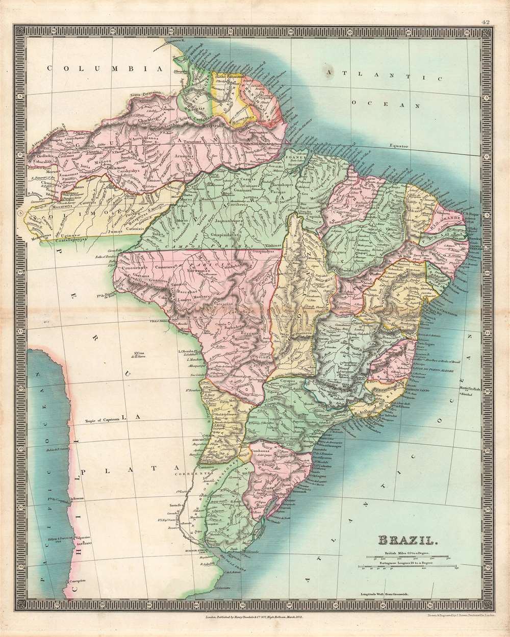
This is a stunning example of the 1831 John Dower and Henry Teesdale map of Brazil and Guyana published in their A New General Atlas of the World. It depicts the region as it emerged from wars of independence against Spain and Portugal, when both borders and political systems were in flux.
Aside from cities and political divisions, mountains are also indicated with hachures, while rivers and coastal features (bays, bars, islands) are assiduously noted. In the Amazon, the names of local indigenous groups are also indicated. Scales are provided in both British miles and Portuguese leagues.
The information presented here was a bit out of date, as Uruguay is here included in Brazil as 'Banda Oriental.' In fact, the territory had its independence recognized in the Treaty of Montevideo in August 1828, following twelve years of Brazilian occupation and warfare (neighboring Paraguay would likewise see a protracted independence struggle against Brazil in the 1860s – 1870s).
A Closer Look
This map illustrates the Empire of Brazil at its greatest extent, roughly a decade after independence from Portugal, along with the Guianas, including British, French, and Dutch colonies. Lands north of the Amazon that were inland from the coast (Guiana), shown here as part of Brazil, were contested between several powers, and were only definitely recognized as Brazilian territory in the early 20th century.Aside from cities and political divisions, mountains are also indicated with hachures, while rivers and coastal features (bays, bars, islands) are assiduously noted. In the Amazon, the names of local indigenous groups are also indicated. Scales are provided in both British miles and Portuguese leagues.
The information presented here was a bit out of date, as Uruguay is here included in Brazil as 'Banda Oriental.' In fact, the territory had its independence recognized in the Treaty of Montevideo in August 1828, following twelve years of Brazilian occupation and warfare (neighboring Paraguay would likewise see a protracted independence struggle against Brazil in the 1860s – 1870s).
Independence and Struggle in Brazil
After several attempted revolts, Brazil succeeded in gaining its independence from Portugal in 1822, a movement that, perhaps unexpectedly, was led by the son of the Portuguese King João VI. However, the country's early years saw a string of revolts and wars, as various social groups and newly independent countries jockeyed for power. Brazil's major opponent was the United Provinces of the Río de la Plata, a predecessor to the Republic of Argentina. In this era, much of the country remained sparsely populated despite continued immigration and a significant portion of the economy relied on slavery and plantation agriculture, though modern industries were developed in the second half of the 19th century.Publication History and Census
This map was engraved by John Dower for the 1831 edition of A New General Atlas of the World, published by Henry Teesdale. This appears to be an especially rare presentation of this map, as most examples from this or other editions of A New General Atlas do not show such vivid and full hand-coloring, only the outlines of territories. The 1831 edition of this map is only independently cataloged in the holdings of four institutions, while the entire atlas is held by roughly a dozen institutions, though as stated above the present map may be distinct from those examples in coloration.CartographerS
John James Dower (June 1, 1825 - 1901) was a well-respected mapmaker, print seller, and publisher based in London, England. Dower is the heir to the more prominent London engraver and mapmaker John Crane Dower (1791 - 1847). Dower worked with many prominent middle to late 19th century London map publishers including Weller, Cassell, Bacon, Petermann, and others. He was elected to the Royal Geographical Society in 1854. Dower also published on maps his own account including one atlas and various school geographies. In addition to his cartographic work, Dower is well known as an engraver of military scenes. More by this mapmaker...
Henry Teesdale (December 1776 - January 1856) was a British map publisher active in the first half of the 19th century. Teesdale was born in London. He was elected to the Royal Geographical Society in 1830. Teesdale initially partnered with John Hordan and William Colling Hobson as Henry Teesdale and Company, but this partnership was dissolved in 1832. Afterwards Teesdale continued to publish maps and atlases on his own account. He worked with several major British map engravers of the period including John Crane Dower, Christopher Greenwood, and Josiah Henshall, among others. His most prominent work is a large map of the world engraved by Dower. He must have enjoyed considerable commercial success because in 1845 he is registered as a partner in the Royal Bank of Scotland. Teesdale died in January of 1856 and was buried in All Souls, Kensal Green. Learn More...
Source
Dower, John, A New General Atlas of the World, (London: Teesdale) 1831.
Condition
Very good.
References
OCLC 43221863.