Digital Image: 1864 McCloskey Map of Brooklyn, New York City, in 1766
Brooklyn1766-mccloskey-1864_d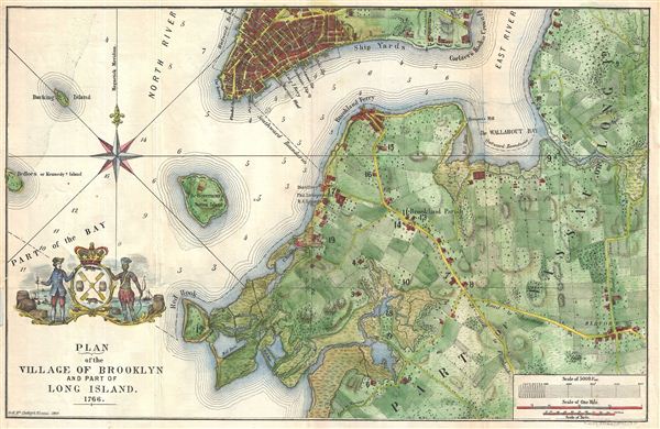

Title
Plan of the Village of Brooklyn and part of Long Island 1766.
1864 (dated) 11 x 17 in (27.94 x 43.18 cm)
1864 (dated) 11 x 17 in (27.94 x 43.18 cm)
Description
FOR THE ORIGINAL ANTIQUE MAP, WITH HISTORICAL ANALYSIS, CLICK HERE.
Digital Map Information
Geographicus maintains an archive of high-resolution rare map scans. We scan our maps at 300 DPI or higher, with newer images being 600 DPI, (either TIFF or JPEG, depending on when the scan was done) which is most cases in suitable for enlargement and printing.
Delivery
Once you purchase our digital scan service, you will receive a download link via email - usually within seconds. Digital orders are delivered as ZIP files, an industry standard file compression protocol that any computer should be able to unpack. Some of our files are very large, and can take some time to download. Most files are saved into your computer's 'Downloads' folder. All delivery is electronic. No physical product is shipped.
Credit and Scope of Use
You can use your digial image any way you want! Our digital images are unrestricted by copyright and can be used, modified, and published freely. The textual description that accompanies the original antique map is not included in the sale of digital images and remains protected by copyright. That said, we put significant care and effort into scanning and editing these maps, and we’d appreciate a credit when possible. Should you wish to credit us, please use the following credit line:
Courtesy of Geographicus Rare Antique Maps (https://www.geographicus.com).
How Large Can I Print?
In general, at 300 DPI, you should at least be able to double the size of the actual image, more so with our 600 DPI images. So, if the original was 10 x 12 inches, you can print at 20 x 24 inches, without quality loss. If your display requirements can accommodate some loss in image quality, you can make it even larger. That being said, no quality of scan will allow you to blow up at 10 x 12 inch map to wall size without significant quality loss. For more information, it is best consult a printer or reprographics specialist.
Refunds
If the high resolution image you ordered is unavailable, we will fully refund your purchase. Otherwise, digital images scans are a service, not a tangible product, and cannot be returned or refunded once the download link is used.
Cartographer
Henry McCloskey (fl. c. 1863 - 1867) was a journalist working in Brooklyn in the mid 19th century. He was the first regular reporter employed by the Brooklyn Daily Eagle and consequently the first true Brooklyn reporter. When the editor Arnold resigned, McCloskey stepped up to the position became Editor-in-chief. An ardent southern sympathizer and fierce advocate of states' rights, McCloskey had no shame in using the Eagle to express his radical political views. In 1861, following the outbreak of the Civil War, McCloskey published a series of aggressive anti-war editorials. Shortly thereafter, the Eagle, along with several other news papers including the New York News, were accused of disloyalty to the Union and denied access to the U.S. Mail system. The charges were dropped when McCloskey resigned shortly afterwards. McCloskey's true interest was government and in 1863 he was voted city clerk for Brooklyn. He retained this position from 1863 to 1867. Both his predecessor and successor seem to have been William Bishop. One of the duties of the city clerk was to publish an annual report detailing the government, progress, urban planning and development of the city. The resulting Manual bearing the McCloskey name was published during his four years of tenure as City Clerk. The first Brooklyn Manual was published in 1855 following the consolidation of the city. The Manual was published under various names and in various forms until 1888. More by this mapmaker...
Source
McCloskey, H., Manual of the City and Corporation of Brooklyn, 1864, 1864.
References
Haskell, D., Manhattan Maps A Co-operative List, 319-346 (the Ratzer Plan).