
This item below is out of stock, but another example (left) is available. To view the available item, click "Details."
Details
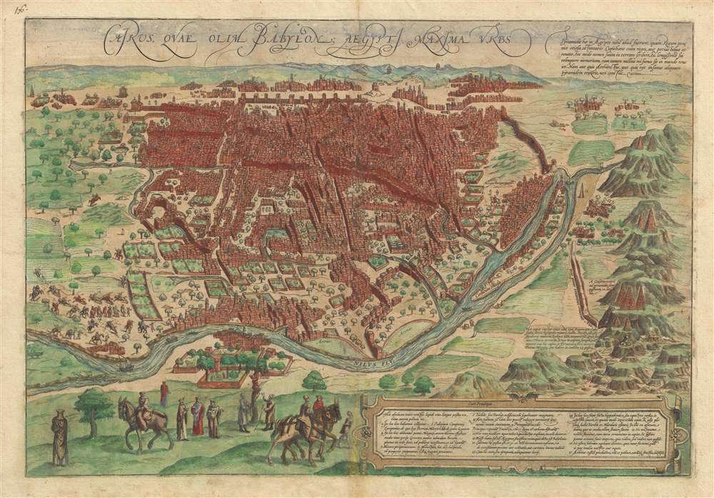
1572 Braun and Hogenberg View Map of Cairo, Egypt
$950.00
1572 Braun and Hogenberg View Map of Cairo, Egypt
Cairo-braunhogenberg-1572$487.50

Title
Cairus, quae olim Babylon; Aegypti Maxima Urbs.
1572 (undated) 14.5 x 20.5 in (36.83 x 52.07 cm)
1572 (undated) 14.5 x 20.5 in (36.83 x 52.07 cm)
Description
This is a striking c. 1572 view map of Cairo, Egypt during the Ottoman Period issued by Braun and Hogenberg. The map presents Cairo from the right bank of the Nile, so looking towards the southeast with the Pyramids of Giza and the Great Sphinx appearing at right. Braun and Hogenberg's Cairo is a city of uniform rectilinearity interspaced with fortresses, gated gardens, and soaring minarets. The Great Pyramids of Giza, appearing at right, are highly stylized, presented on green hills, and clearly indicate that artist had never actually seen them.
Some have wondered at the odd title which translates, roughly, to 'Cairo formerly known as Babylon.' This is a reference not the Babylon of Mesopotamia, by rather to Babylon Fortress, an ancient citadel located in what is today Coptic Cairo. The fortress marked the boundary between Lower and Middle Egypt where river craft ascending or descending the Nile paid tolls. The decision to name the fortress Babylon is a matter of contention among scholars of antiquity. Diodorus ascribes the erection of the fort to rebel Assyrian captives in the reign of Sesostris, who named it after the great city. The Jewish historian Josephus, on the other hand, attributes its structure to Babylonian followers of Cambyses, which makes more sense.
This early map and view was published in Braun and Hogenberg's Civitatus Orbis Terrarum, the most important town book of the 16th Century.
European Fascination with the Orient
The map offers copious annotations that underscore growing European fascination with the orients as a place of heathen decadence and ancient wonder. Braun's description of Cairo:Cairo is said to number 30,000 houses altogether. There are very many princely palaces and temples here, but also many hospices, schools and baths and large buildings containing the tombs of important persons. The streets contain such a throng of people, horses and mules that it is not possible to pass without obstacle. [...] The women, too, wear trousers, made of silk, trimmed with pearls and precious gems, like the men. The men are also allowed to have several wives.The Latin text at the top describes the Pyramids of Giza:
These pyramids were nothing but an idle display of royal wealth. In this way the kings, or rather the crowned beasts, namely hoped to make their names immortal on earth and to keep their memory alive for a long time. Nothing in the world is of less fame, however, since neither the architect nor the insane king who built a pyramid is recorded.Text next to the Great Sphinx describes her,
This head consists of a single piece of stone; the face alone is ten lesser hexapedes (a measure of length equal to six feet) long. According to Strabo, it is a monument to a beautiful, tragic hetaera named Rhodopis. The king took her as his wife and after her death he had this head and pyramid built for her.Cairo as Babylon?
Some have wondered at the odd title which translates, roughly, to 'Cairo formerly known as Babylon.' This is a reference not the Babylon of Mesopotamia, by rather to Babylon Fortress, an ancient citadel located in what is today Coptic Cairo. The fortress marked the boundary between Lower and Middle Egypt where river craft ascending or descending the Nile paid tolls. The decision to name the fortress Babylon is a matter of contention among scholars of antiquity. Diodorus ascribes the erection of the fort to rebel Assyrian captives in the reign of Sesostris, who named it after the great city. The Jewish historian Josephus, on the other hand, attributes its structure to Babylonian followers of Cambyses, which makes more sense.
This early map and view was published in Braun and Hogenberg's Civitatus Orbis Terrarum, the most important town book of the 16th Century.
CartographerS
Georg Braun (1541 – March 10, 1622) was a German deacon, viewmaker, and typo-geographer based in Cologne. Along with Franz Hogenberg (1535 - 1590), Braun is best known for his publication of the highly influential city atlas Civitates Orbis Terrarum. The six volume work, with some 546 views, was published between 1572 and 1617 and intended a companion to Abraham Ortelius' Theatrum Orbis Terrarum - thus certain obvious stylistic similarities. In compiling the Civitates Braun took on the role of editor while most of the engraving work was completed by Franz Hogenberg. Braun died, as he was born, in Cologne. More by this mapmaker...
Franz Hogenberg (1535 - 1590), often called 'Master Franz,' was a Flemish engraver active in the late 16th century. Hogenberg was born in Mechelen, the son of Nicolas Hogenberg, where he trained under the cartographer H. Terbruggen. He later relocated to Antwerp where he achieved success as an engraver, working with Abraham Ortelius, Hieronymus Cock, and others. In 1568, his name appeared on the list of those banned from the Netherlands by the Duke of Alva, forcing his family to flee to London. There he engraved for Christopher Saxon's Atlas of England and Wales. By 1570 he emigrated to Germany settling in Cologne. In Cologne he married his second wife, Agnes Lomar, with whom he had six children. In 1579 the couple were briefly imprisoned for holding illicit secret religious meetings, but were released in short order. Along with German cleric George Braun (1541 – March 10, 1622), Hogenberg issued the highly influential city atlas Civitates Orbis Terrarum. The six volume work, with some 546 views, was published between 1572 and 1617 and intended a companion to Abraham Ortelius' Thatrum Orbis Terrarum - thus certain obvious stylistic similarities. In compiling the Civitates Hogenberg took on the role of engraver while most of the editing was left to Georg Braun. Hogenberg died in Cologne, Germany, before the Civitates was completed. After his death, Hogenberg's work was continued by his son, Abraham Hogenberg, who, under the direction of Agnes, his mother, took over his father's enterprise at just 20. Learn More...
Source
Braun, G. and Hogenberg, F. Civitatus Orbis Terrarum, 1572.
The Civitatus Orbis Terrarum is an 6-volume atlas of cities, or town book, compiled and written by George Braun, Canon of Cologne Cathedral and Franz Hogenberg. Braun and Hogenberg gathered together vast amounts of information and draft plans to produce over 500 city views/maps published in six parts between 1572 and 1617. Most of the town views and plans were engraved by Simon van den Neuvel (Novellanus) and Frans Hogenberg, many after drawings by Joris Hoefnagel. The Civitatus Orbis Terrarum was printed in Cologne, but in the Flemish style after Abraham Ortelius, the preeminent cartographer of the period. The text throughout is the work of Braun. The work proved to be a great success, reflecting the period's greater fascination with notable metropolises than with national boundaries. After the initial publication of volume 1, the popularity of the led to a second volume. In the introduction to volume 2, Braun requests that those who live in cities not represented, sent details of their own metropolises. This led to the publication of volumes 3, 4, and 5. Volume 6, the last, did not appear until 1617 under Franz Hogenberg's son, Abraham Hogenberg. The volumes include
- Civitates orbis terrarium, first edition 1572.
- De praecipuis, totius universi urbibus, liber secundus, first edition 1575.
- Urbium praecipuarum totius mundi, liber tertius, first edition 1581.
- Urbium praecipuarum totius mundi, liber quartus, first edition 1588.
- Urbium praecipuarum mundi theatrum quintum, first edition 1596.
- Theatri praecipuarum totius mundi urbium liber sextus, first edition 1617.
Condition
Very good. Minor discoloration bottom centerfold
References
OCLC 494245933. Fauser, Alois, Repertorium Slterer Topographie #6298.