1853 Direccion de Hidrografia Nautical Chart or Map of the Canary Islands
CanaryIslands-bregante-1853$850.00


Title
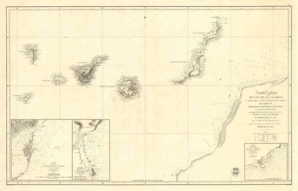
Carta Esférica de las Islas Canarias y Parte de la Costa Ocidental de Africa, que Comprende desde Puerto Cansado Hasta Cabo Bojador, levantada en 1834 á 1838.
1853 (dated) 24 x 37.5 in (60.96 x 95.25 cm) 1 : 725000
1853 (dated) 24 x 37.5 in (60.96 x 95.25 cm) 1 : 725000
Description
A striking 1853 nautical chart or maritime map of the Canary Islands and the coast of Africa in the vicinity of Cape Bojador. The map depicts one of the most dangerous passages in African navigation - the rounding of Cape Bojador. The Canary Islands were significant to mariners from the 15th through the 19th centuries, when they were considered a vital stopover point and bridge between four continents: Africa, North America, South America, and Europe.
Considerably rare. Examples are recorded at the University of Wisconsin, the Museu Marítim de Barcelona, and the Biblioteca de Catalunya. No record on the private market.
Cape Bojador
Although it may not look intimidating on a map, Cape Bojador had long been a stumbling block in the European exploration of Africa. Winds change dramatically at this point, blowing strongly from the northeast, as shown here, and there are numerous shoals, sand bars, and rocks near the surface. Until 1434, no European ship had made it past the Cape. In that year, the Portuguese mariner Gil Eanes broke with the tradition of hugging the coast and sailed further out to sea to round the Cape, thus finding more favorable winds and deeper waters. Knowledge of how to round Cape Bojador was a major breakthrough for the Portuguese, ultimately leading to Bartolomeu Dias' 1488 rounding of Africa and Vasco de Gama's opening of maritime trade with the Indies. Nonetheless, Cape Bojador remained a dangerous stretch of sea, with more than 30 shipwrecks recorded between 1790 and 1806.Publication History and Census
This chart was published in 1853 by the Direccion de Hidrografia in Madrid based upon the cartography of A. T. E. Vidal and Lieutenant Arlett, both of the ship R. R. Inglesa. It was drafted by Francisco Bregante y Orbay and engraved by Pascual Serra y Mas. We are aware of only one edition.Considerably rare. Examples are recorded at the University of Wisconsin, the Museu Marítim de Barcelona, and the Biblioteca de Catalunya. No record on the private market.
CartographerS
The Direccion Hidrografía (1787 - 1927), also known as the Deposito Hydrografico and the Direction de Hidrografía, was the Spanish equivalent of the British Admiralty or the U.S. Coast Survey. This organization, founded in 1787, was commissioned to collect and produce accurate nautical charts of all waters frequented by Spanish vessels. In essence, it replaced the Casa de la Contratación de las Indias (House of Trade of the Indies), which closed its doors in 1790. Like most such organizations, the Direccion Hidrografía marked a new age in cartography. Rather than simply collect charts created by navigators, explorers, and merchants, the Direccion Hidrografía worked closely with naval and military personnel to mount cartographic and hydrographic expeditions in pursuit of the most accurate hydrographical, astronomical, and geodetic measurements. The Direccion Hidrografía created a massive library of nautical charts that, though not nearly as common as similar nautical charts by the U.S. Coast Survey and British Admiralty, are highly desirable for the beauty of their manufacture as well as their accuracy and detail. The office was originally located on Calle Ballesta, but relocated to 36 Alcala, both in Madrid. After 1908 the Dirección was subsumed into other governmental agencies. In 1927 the Direccion was absorbed into the Institute and Observatory of San Fernando, located in Cadiz. The library of original maps, charts, and journals was transferred to the Naval Museum of Madrid - where it resides to this day. More by this mapmaker...
Francisco Bregante y Orbay (fl. 1840 - 1867) was a Spanish engraver and draftsman active with the Dirección Hidrografía in the middle part of the 19th century. Bregante y Orbay specialized in lettering and text. A relative, Salvador Bregante y Orbay, also worked for the Dirección Hidrografía in a related capacity. Learn More...
Pascual Serra y Mas (fl. c. 1853 - 1883) was a Spanish line and letter engraver engaged with the Direccion de Hidrografia or Deposito Hidrografico in the second half of the 19th century. Learn More...
Condition
Very good. Some pencil annotations relating to an 1864 voyage.
References
OCLC 803449386.