1893 Johnston Map of Central Asia Tracing the Route of the Earl of Dunmore
CentralAsia-johnston-1893$450.00

Title
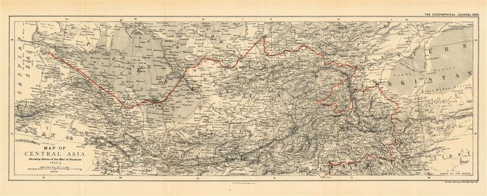
Map of Central Asia Showing the Route of the Earl of Dunmore 1892-3.
1893 (dated) 8.75 x 23.25 in (22.225 x 59.055 cm) 1 : 1000000
1893 (dated) 8.75 x 23.25 in (22.225 x 59.055 cm) 1 : 1000000
Description
This is an 1893 map by William and Alexander Keith Johnston of Central Asia, published by the Royal Geographic Society, to trace the route taken by the Earl of Dunmore in his travels through Kashmir, the Xinjiang province of China, Tajikistan, Kyrgyzstan, Uzbekistan, and through Turkmenistan to the Caspian Sea. The region - largely a Chinese frontier - was the site of significant Russian efforts to exert influence at the time, and it is in that context that the Earl of Dunmore’s journey took place. Following the track, for example, one sees what appears to be a curious detour into the Pamir mountains between Yarkand and Kashgar; here, Dunmore’s expedition was following a Chinese force sent to counter Russian incursions Aktash region. The region was also the site of conflict between Russian and Afghan forces - indeed, the journey took place only a few years before the border between Russia and Afghanistan was set with the signing of the Pamir Boundary Commission protocols in 1895. Dunmore's return route from Samarkand was undertaken on the Russian Trans-Caspian Railway; constructed in order to facilitate Russian troop movements along the frontier, the British considered this railway to be a particular threat to their interests in Asia.
The Great Game - the struggle for Afghanistan
From 1830 until 1895, a political and diplomatic confrontation, known as 'The Great Game', existed between the British Empire and the Russian Empire over Afghanistan and other territories in Central and Southern Asia. 'The Great Game', as it is known, was ignited due to Russian fears that Britain was making commercial and military inroads in Central Asia, while Britain mutually feared Russia adding 'the jewel in the crown' (India) to its vast empire in Asia. Several wars were fought, including the First Anglo-Afghan War in 1838, the First Anglo-Sikh War in 1845, the Second Anglo-Sikh War in 1848, and the Second Anglo-Afghan War in 1878, along with the Russian annexations of Khiva, Bukhara, and Kokand. Per historians, the Great Game ended on September 10, 1895 with the signing of the Pamir Boundary Commission protocols, which defined the border between Afghanistan and the Russian Empire.Publication History and Census
The map was published in the Geographical Journal of 1893 to accompany the Earl of Dunmore's account of his journey. The separate map is catalogued only once in institutional collections, at the University of Chicago. The map appears to be scarce on the market.CartographerS
Alexander Keith Johnston (December 28, 1804 - July 9, 1871) was a Scottish cartographer and map publisher active in the middle portion of the 19th century. Johnson was born at Kirkhill, near Edinburgh, Scotland. He studied at the University of Edinburgh where he apprenticed as an engraver. Around 1826, in partnership with his brother William, he founded a cartographic printing and engraving firm with the imprint "W. and A. K. Johnston." Johnston made a name for himself in educational geography, publishing numerous maps for use in schools. His brother, William Johnston, eventually left the firm to pursue a career in politics, eventually becoming the Lord Provost of Edinburgh. Alexander's son, who would bear the same name, became a geographer and explorer, suffering an untimely death on the Royal Geographical Society's 1879 expedition to Lake Nyasa. More by this mapmaker...
Royal Geographical Society (fl. 1830 - present) is a British Society established in 1830 to promote geographical science and exploration. Originally titled the "Geographical Society of London", the RGS received its royal charter from Queen Victoria in 1859 shortly after absorbing several similar but more regional societies including the African Association, the Raleigh Club and the Palestine Association. The RGS sponsored many of the most important and exciting voyages of exploration ever undertaken, including the exploration of Charles Darwin, David Livingstone, Robert Falcon Scott, Richard F. Burton, John Speke, George Hayward, H. M Stanley, Ernest Shackleton and Sir Edmond Hillary. Today, the RGS remains a leading global sponsor of geographical and scientific studies. The Society is based in Lowther Lodge, South Kensington, London. Learn More...
Condition
Very good. Even overall toning. Light wear along original fold lines. Verso repairs to fold separations. Blank on verso.
References
OCLC 71212659.