1933 Postal Atlas of China Map of Chahar, Inner Mongolia
Chahar5-postalatlas-1933$400.00

Title
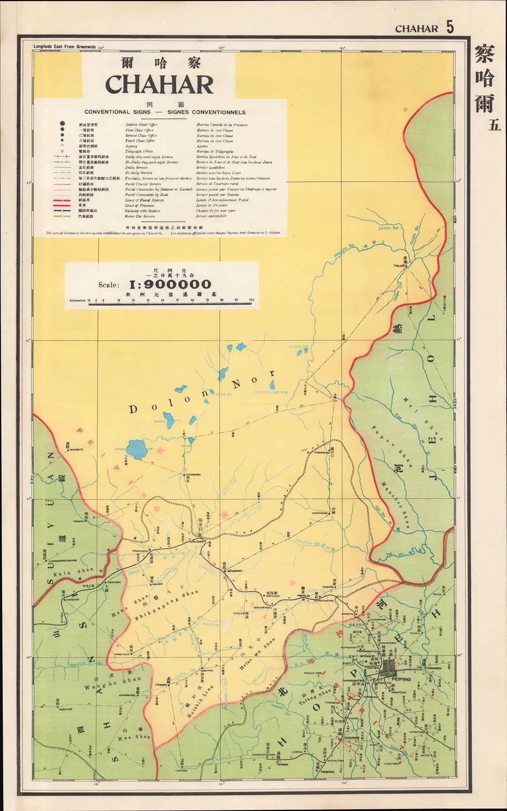
察哈爾 / Chahar.
1933 (undated) 24 x 15 in (60.96 x 38.1 cm) 1 : 900000
1933 (undated) 24 x 15 in (60.96 x 38.1 cm) 1 : 900000
Description
This is a map of Chahar Province (Inner Mongolia) from the 1933 edition of The Postal Atlas of China (中華郵政輿圖), compiled by Charles Jacot-Guillarmod. It presents the limited but evolving postal infrastructure of the region, an impressive feat given the difficult terrain and lack of infrastructure.
The largest city and administrative center of the province was Kalgan, a romanization of its Mongol name which means 'gate'. In Mandarin it is known as Zhangjiakou (張家口). As its name references, Kalgan sat on the outer portion of the Great Wall and housed a large gate in the wall called Dajing Gate (大境門). In the Ming and Qing periods, the city was an important meeting point of the Chinese and Mongolian worlds, and a major stop on trade routes between Russia and China. Because the fortifications in the area were meant to protect Beijing and had to be passed through to get there from the north, Kalgan was also known as the 'Gateway to Beijing.'
To the north of Kalgan are Dolon Nor, meaning 'seven lakes' as well as the area that was home to the summer capital of Kublai Khan known as Xanadu or Shangdu. Xanadu was memorably lauded for its beauty and magnificence by Marco Polo and afterwards took on a semi-mythical status in Western literature. Portions of the great capital have been excavated some 17 miles northwest of Duolun, towards top-right, and were made a UNESCO World Heritage Site in 2012.
When the Qing collapsed, a de facto independent government known as the Bogd Khanate formed in Outer Mongolia. The new Chinese Republic claimed all of Mongolia as Chinese territory, leading Mongolian nobles to seek foreign assistance wherever they could, aligning first with White Russians (who helped fight off a Chinese attempt to occupy Outer Mongolia) and then the Soviets, resulting in the establishment of the Mongolian People's Republic.
Chahar was created soon after the birth of the Chinese Republic and was significantly reorganized by the national government based in Nanjing in 1928. As with the rest of northern China, Chahar was placed in a tenuous position after the creation of the Japanese puppet state of Manchukuo in 1932. Japanese military incursions combined with Mongolian nobles' residual bitterness about being forcibly incorporated into China, leading to the formation of a puppet state called Mengjiang in 1936 - 1937.
The second edition of the Postal Atlas was issued in 1919 following a Ministry of Education system to standardize the Beijing dialect in all elementary schools throughout China. This led to a resurgence of the Wade system. Nonetheless, in 1931, the French postal co-director Henri Picard-Destelain ordered a return to the Nanking Syllabary. The Chinese Postal System remained under French management until 1943 when the Japanese invaders ousted A. M. Chapelain, the last French head of the China Post.
A Closer Look
This map depicts the Province of Chahar, situated northwest of Beijing (here as Peiping). Its southern half consisted of lands between two branches of the Great Wall of China, while its northern half included lands beyond the Great Wall. This was also a cultural dividing line, with areas to the south of the wall being sedentary and primarily Chinese and areas beyond the wall being mostly nomadic and Mongolian, except for the scattered towns and cities which were predominantly Chinese (though communities and families were often mixed).The largest city and administrative center of the province was Kalgan, a romanization of its Mongol name which means 'gate'. In Mandarin it is known as Zhangjiakou (張家口). As its name references, Kalgan sat on the outer portion of the Great Wall and housed a large gate in the wall called Dajing Gate (大境門). In the Ming and Qing periods, the city was an important meeting point of the Chinese and Mongolian worlds, and a major stop on trade routes between Russia and China. Because the fortifications in the area were meant to protect Beijing and had to be passed through to get there from the north, Kalgan was also known as the 'Gateway to Beijing.'
To the north of Kalgan are Dolon Nor, meaning 'seven lakes' as well as the area that was home to the summer capital of Kublai Khan known as Xanadu or Shangdu. Xanadu was memorably lauded for its beauty and magnificence by Marco Polo and afterwards took on a semi-mythical status in Western literature. Portions of the great capital have been excavated some 17 miles northwest of Duolun, towards top-right, and were made a UNESCO World Heritage Site in 2012.
Mongolia between Empires
Many Mongol groups allied with the Manchus prior to their takeover of China in the mid-17th century. They were therefore able to maintain their autonomy for much of the Qing era (1644 – 1911) and serve throughout the empire as soldiers and officials. However, overpopulation and natural disasters in the Chinese interior sent migrants and refugees streaming to the Mongolian frontier in the 18th and 19th centuries. Convicts were also often exiled to Mongolia as a form of punishment. The Qing initially tried to limit migration but later encouraged it in Inner Mongolia, where the Mongols quickly became a minority in their own land. The situation was different in Outer Mongolia, where terrain was harsher and Chinese migrants were few.When the Qing collapsed, a de facto independent government known as the Bogd Khanate formed in Outer Mongolia. The new Chinese Republic claimed all of Mongolia as Chinese territory, leading Mongolian nobles to seek foreign assistance wherever they could, aligning first with White Russians (who helped fight off a Chinese attempt to occupy Outer Mongolia) and then the Soviets, resulting in the establishment of the Mongolian People's Republic.
Chahar was created soon after the birth of the Chinese Republic and was significantly reorganized by the national government based in Nanjing in 1928. As with the rest of northern China, Chahar was placed in a tenuous position after the creation of the Japanese puppet state of Manchukuo in 1932. Japanese military incursions combined with Mongolian nobles' residual bitterness about being forcibly incorporated into China, leading to the formation of a puppet state called Mengjiang in 1936 - 1937.
The Postal Atlas of China (中華郵政輿圖)
Compiled by Charles Jacot-Guillarmod, this atlas contains maps covering all of China in considerable detail. Most were derived from regional working postal maps. The legends on the maps are written in English, Chinese, and French. The history of the The Postal Atlas of China is closely related to attempts to Romanize placenames in the Chinese Postal System. The first atlas followed the 1906 Shanghai Imperial Postal Joint-Session Conference to develop a system of Romanization following Herbert Giles' 'Nanking Syllabary.' The Giles 'Nanking syllabary' was popular with the French-dominated Chinese Postal Service, which considered the earlier Beijing based system developed by Thomas Francis Wade as too Anglophone. As was the case for other bureaucratic offices at this time, foreign advisors were often brought in as consultants or even government officials.The second edition of the Postal Atlas was issued in 1919 following a Ministry of Education system to standardize the Beijing dialect in all elementary schools throughout China. This led to a resurgence of the Wade system. Nonetheless, in 1931, the French postal co-director Henri Picard-Destelain ordered a return to the Nanking Syllabary. The Chinese Postal System remained under French management until 1943 when the Japanese invaders ousted A. M. Chapelain, the last French head of the China Post.
Publication History and Census
There are four known editions of this atlas: 1907-08 (Shanghai, replacing the 1903 postal wall map, 21 maps plus index map), 1919 (Beijing, 47 maps), 1933 (Nanjing), and 1936 (Nanjing). The atlas was compiled by the French topographical engineer Charles Jacot-Guillarmod and published by the Directorate General of Posts (郵政總局). This edition is held by a handful of university libraries and research institutions in North America and Europe, as well as institutions in mainland China and Taiwan.Cartographer
Charles Jacot-Guillarmod (1868 – August 14, 1925) was a Swiss topographical engineer active in the late 19th and early 20th century. Charles was born in Le Chaux-de-Fonds, in the Canton of Neuchatel, Switzerland. He attended the Eidgenössische Technische Hochschule Zürich (ETHZ), where he acquired a degree in Topographical Engineering. After graduating served the Swiss Federal Topographical Bureau from 1890 – 1914, contributed significantly to the Topographical Atlas of Switzerland. He was dismissed from his government topographical posted in 1914. Independent of a paid post he turned his attentions to his interested in high alpine cartography, producing two topographical sketches of Himalayan peaks (K2 and Kanchenjunga) based upon photographs taken by his cousin, the famed mountaineer Jules Jacot-Guillarmod. From 1916 to 1922 he relocated to Beijing where he taught geodesy and topography at the Chinese Army Survey School. There, he was also contracted to compile the 1919 second edition of the China Postal Atlas. When the Chinese government could no longer pay him, he returned to Switzerland in 1923 where he compiled a large scale topographic map of Mount Olympus. His final work was a large scale map of Mount Everest commissioned by the Royal Geographical Society, London, based upon the surveying achievements of a British expedition. More by this mapmaker...
Source
China. You zheng zong ju, Zhonghua min guo you zheng yu tu, (Nanking: Directorate General of Post) 1933.
Condition
Very good.
References
OCLC 5371414, 17468267.