1933 Postal Atlas of China Map of Zhejiang (Chekiang) Province
Chekiang19-postalatlas-1933$400.00

Title
浙江 / Chekiang.
1933 (undated) 24.25 x 29 in (61.595 x 73.66 cm) 1 : 900000
1933 (undated) 24.25 x 29 in (61.595 x 73.66 cm) 1 : 900000
Description
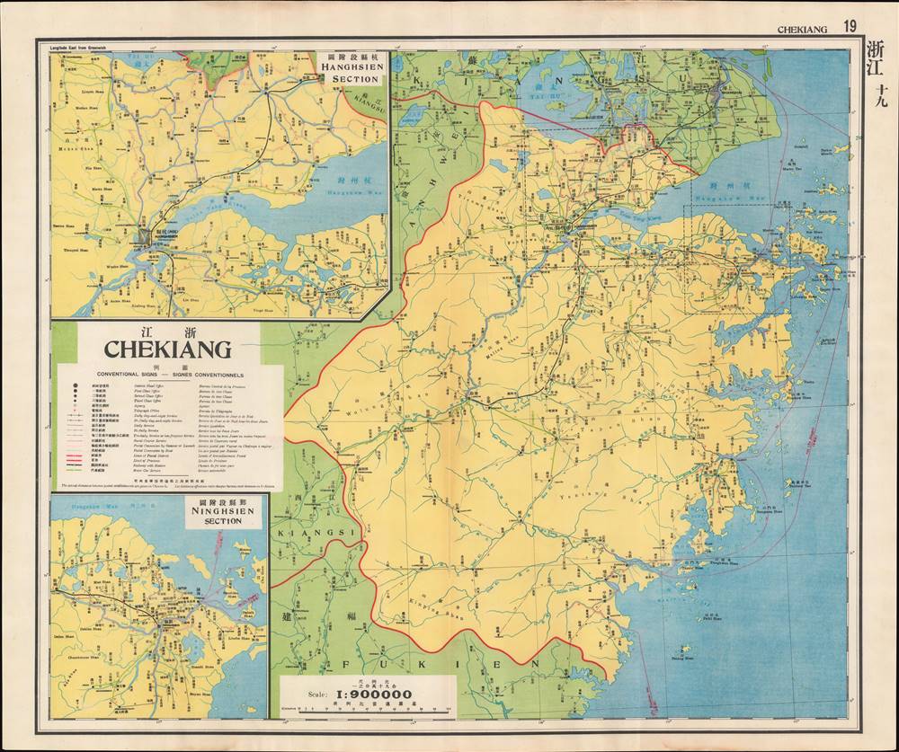
This is a map of Zhejiang (Chekiang) Province from the 1933 edition of The Postal Atlas of China (中華郵政輿圖), compiled by Charles Jacot-Guillarmod. It presents the evolving postal infrastructure of the region, reflecting a broader modernization drive by the Nanjing government.
The markings on the map indicated in the legend provide a great deal of information about the postal and transportation infrastructure in China at this time by indicating the frequency of service along various routes. The numbers along the routes represent Chinese li (里), equivalent to roughly 500 meters.
To the east, Ningbo is a coastal hub surrounded by islands with a tradition of fishing, trade, and other maritime activities. Xikou (溪口, here Kikow) just west of Ningbo is the hometown of Chiang Kai-Shek, the leader and 'Generalissimo' of China when this map was made.
The dialects and cultures of the mountainous interior are highly localized, similar to the neighboring provinces of Anhui (Anhwei), Jiangxi (Kiangsi), and Fujian (Fukien), while the southern coast, particularly the city of Wenzhou (here Yungkia 永嘉), is a conduit between the inland and the maritime worlds, the latter stretching throughout Southeast Asia.
After the purging of Communists, Chiang established a new national regime in Nanjing. In the decade that followed, despite weak authority, civil war, a Communist insurgency, and an incremental Japanese invasion of northern China, the Nanjing Government and the Guomindang were able build something like a modern, functioning bureaucratic state, particularly in the Lower Yangzi Delta around Nanjing and Shanghai, and successfully complete a range of hallmark infrastructure and modernization projects. Nevertheless, full-scale war with Japan in 1937 derailed these efforts, leading ultimately to Chiang's retreat to Taiwan and the Communist takeover of mainland China.
The second edition of the Postal Atlas was issued in 1919 following a Ministry of Education system to standardize the Beijing dialect in all elementary schools throughout China. This led to a resurgence of the Wade system. Nonetheless, in 1931, the French postal co-director Henri Picard-Destelain ordered a return to the Nanking Syllabary. The Chinese Postal System remained under French management until 1943 when the Japanese invaders ousted A. M. Chapelain, the last French head of the China Post.
A Closer Look at the Map
This map is the nineteenth in the atlas's series. Inset maps are provided for Hangzhou (杭州, here Hanghsien) and Ningbo (寧波, here Ninghsien), important cities in the northern part of the province. As is reflected in the postal infrastructure, this part of Zhejiang was the most developed and modernized.The markings on the map indicated in the legend provide a great deal of information about the postal and transportation infrastructure in China at this time by indicating the frequency of service along various routes. The numbers along the routes represent Chinese li (里), equivalent to roughly 500 meters.
Regions of Zhejiang
Long one of the most populous and wealthiest regions of China, Zhejiang is more appropriately compared to a European country like France or Italy than a region or province of those countries. Like an Italy or France, Zhejiang has several distinct regions that have their own history, culture, dialect, and identity. In the north, Hangzhou has historically been tied to the Jiangnan region (江南), including Suzhou and Nanjing, in large part because Hangzhou was the southern terminus of the Grand Canal which stretched all the way to Beijing. Hangzhou has for centuries been famous throughout China for its scenic sites (especially West Lake) and cultural sophistication. It was the capital of the Southern Song Dynasty in the 12th and 13th centuries, when it was likely the largest city in the world. The linguistic and cultural relationship with wider Jiangnan is more pronounced in the north, but evident throughout the province in language, cuisine, and other elements of culture.To the east, Ningbo is a coastal hub surrounded by islands with a tradition of fishing, trade, and other maritime activities. Xikou (溪口, here Kikow) just west of Ningbo is the hometown of Chiang Kai-Shek, the leader and 'Generalissimo' of China when this map was made.
The dialects and cultures of the mountainous interior are highly localized, similar to the neighboring provinces of Anhui (Anhwei), Jiangxi (Kiangsi), and Fujian (Fukien), while the southern coast, particularly the city of Wenzhou (here Yungkia 永嘉), is a conduit between the inland and the maritime worlds, the latter stretching throughout Southeast Asia.
The Nanjing Decade
Nanjing became the capital city of China in 1927-28, following the partial reunification of the country by Chiang Kai-Shek's forces in the Northern Expedition. A key turning point in this effort was the Shanghai 'White Terror' of April 1927, when Chiang enlisted the criminal Green Gang to murder Communist agents and activists who had called a general strike in the city. This marked a definitive break between the Nationalists and Communists, who had been cooperating in an uneasy alliance to unify the country up to that point.After the purging of Communists, Chiang established a new national regime in Nanjing. In the decade that followed, despite weak authority, civil war, a Communist insurgency, and an incremental Japanese invasion of northern China, the Nanjing Government and the Guomindang were able build something like a modern, functioning bureaucratic state, particularly in the Lower Yangzi Delta around Nanjing and Shanghai, and successfully complete a range of hallmark infrastructure and modernization projects. Nevertheless, full-scale war with Japan in 1937 derailed these efforts, leading ultimately to Chiang's retreat to Taiwan and the Communist takeover of mainland China.
The Postal Atlas of China (中華郵政輿圖)
Compiled by Charles Jacot-Guillarmod, this atlas contains maps covering all of China in considerable detail. Most were derived from regional working postal maps. The legends on the maps are written in English, Chinese, and French. The history of the The Postal Atlas of China is closely related to attempts to Romanize placenames in the Chinese Postal System. The first atlas followed the 1906 Shanghai Imperial Postal Joint-Session Conference to develop a system of Romanization following Herbert Giles' 'Nanking Syllabary.' The Giles 'Nanking syllabary' was popular with the French-dominated Chinese Postal Service, which considered the earlier Beijing based system developed by Thomas Francis Wade as too Anglophone. As was the case for other bureaucratic offices at this time, foreign advisors were often brought in as consultants or even government officials.The second edition of the Postal Atlas was issued in 1919 following a Ministry of Education system to standardize the Beijing dialect in all elementary schools throughout China. This led to a resurgence of the Wade system. Nonetheless, in 1931, the French postal co-director Henri Picard-Destelain ordered a return to the Nanking Syllabary. The Chinese Postal System remained under French management until 1943 when the Japanese invaders ousted A. M. Chapelain, the last French head of the China Post.
Publication History and Census
There are four known editions of this atlas: 1907-08 (Shanghai, replacing the 1903 postal wall map, 21 maps plus index map), 1919 (Beijing, 47 maps), 1933 (Nanjing), and 1936 (Nanjing). The atlas was compiled by the French topographical engineer Charles Jacot-Guillarmod and published by the Directorate General of Posts (郵政總局). This edition is held by a handful of university libraries and research institutions in North America and Europe, as well as institutions in mainland China and Taiwan.Cartographer
Charles Jacot-Guillarmod (1868 – August 14, 1925) was a Swiss topographical engineer active in the late 19th and early 20th century. Charles was born in Le Chaux-de-Fonds, in the Canton of Neuchatel, Switzerland. He attended the Eidgenössische Technische Hochschule Zürich (ETHZ), where he acquired a degree in Topographical Engineering. After graduating served the Swiss Federal Topographical Bureau from 1890 – 1914, contributed significantly to the Topographical Atlas of Switzerland. He was dismissed from his government topographical posted in 1914. Independent of a paid post he turned his attentions to his interested in high alpine cartography, producing two topographical sketches of Himalayan peaks (K2 and Kanchenjunga) based upon photographs taken by his cousin, the famed mountaineer Jules Jacot-Guillarmod. From 1916 to 1922 he relocated to Beijing where he taught geodesy and topography at the Chinese Army Survey School. There, he was also contracted to compile the 1919 second edition of the China Postal Atlas. When the Chinese government could no longer pay him, he returned to Switzerland in 1923 where he compiled a large scale topographic map of Mount Olympus. His final work was a large scale map of Mount Everest commissioned by the Royal Geographical Society, London, based upon the surveying achievements of a British expedition. More by this mapmaker...
Source
China. You zheng zong ju, Zhonghua min guo you zheng yu tu, (Nanking : Directorate General of Post) 1933.
Condition
Very good. Light wear along original centerfold.
References
OCLC 5371414, 17468267.