1873 John Holmes Cadastral Map of Chelsea and Hell's Kitchen (Manhattan), New York City
ChelseaHellsKitchen-holmes-1873$1,800.00


Title
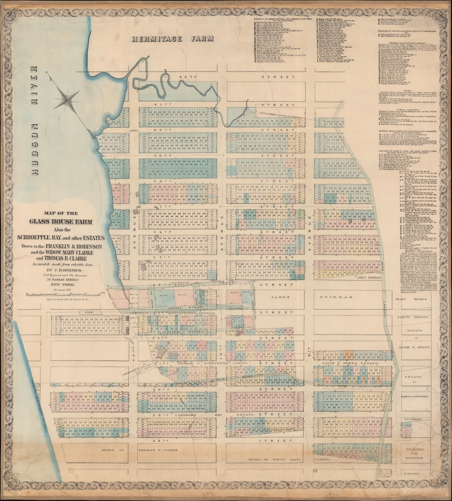
Map of the Glass House Farm Also the Schroepple, Ray, and other estates down to the Franklin and Robinson and the Widow Mary Clarke and Thomas B. Clarke.
1873 (dated) 33.75 x 30.5 in (85.725 x 77.47 cm) 1 : 1800
1873 (dated) 33.75 x 30.5 in (85.725 x 77.47 cm) 1 : 1800
Description
A rare 1873 John Bute Holmes cadastral map of part of the Manhattan neighborhoods Chelsea and Hell's Kitchen, New York City. It is likely the earliest obtainable specific map of this part of Manhattan.
A Closer Look
The map covers northern Chelsea from 27th Street to the southern part of Hell's Kitchen at 42nd Street and from the Hudson River to 8th Avenue, including the present-day mega-development of Hudson Yards. This is one of a series of 21 scarce maps drawn by Holmes between 1867 and 1875. Like all maps in this series, it was independently issued, is quite large, and impressively detailed. The maps illustrate New York City land claims as the vast early estates in central and upper Manhattan were being subdivided under eminent domain laws for assimilation into the grid system. This led to countless legal battles, much of the litigation behind which depended upon access to comprehensive cadastral maps.Breaking Up the Glass House Farm
The current map illustrates the breakup of the Glass House Farm, as well as the estates of George C. Schroepple, George Rapelje, and Cornelius Ray. Some of these claims date to the early Dutch Period of New Amsterdam but were honored by the British even after the takeover. The breakup of the estates is detailed via tables in the upper right quadrant, where individual heirs and landowners are identified. Each is referenced by the New York City record book and page number.A Short History of the Glass House Farm
The map's namesake, the Glass House Farm, was a large farm situated between the Hudson River and Fitzroy Road (as shown here) in today's West 30s. The unusual name, Glass House, refers to a short-lived glass factory that was established on the location in 1754. There was also a nearby tavern of the same name that, at the time of the American Revolutionary War, was a popular roadhouse and inn. The street names on this map reflect the original owners of the farm.The Lotting of Manhattan
In the early 19th century, most of Manhattan was undeveloped farmland, the property of wealthy landowners with claims dating to the Dutch Period. The northern 2/3rd Manhattan was dotted with farms and sprawling gentlemanly estates, many with great manor houses overlooking the Hudson River. The Commissioner's Plan of 1811 and the 1807 Commission Law laid the street grid through many of these properties and gave the city the right to claim the lands under eminent domain, providing due compensation to the landowners. While this work occurred early in lower Manhattan, central and upper Manhattan were not formally acquired by the city until the mid-19th century.What Holmes Did and Why
Holmes became fascinated by the early history of Manhattan real estate ownership, recognizing the wealth to be accrued by accurately understanding the history of city land ownership, division, and inheritance. Moreover, Holmes allied himself with the corrupt Tweed administration, assuring himself and his allies even greater wealth and political power from the eminent domain seizure of old Manhattan estates. Holmes created a series of maps, reminiscent of John Randall's 'Farm Maps', overlaid with property data, showing old estates' borders and notating the land's breakup among various heirs. The complex work of compiling the maps earned Holmes a fortune, with one newspaper suggesting on his death in 1887 that some of his individual maps were worth more than 30,000 USD. There is no complete carto-bibliography of Holmes' maps, but we believe there to be at least 50 maps, possibly more.Publication History and Census
This map is rare. Only 2 examples are cataloged in the OCLC: New York State Library and another at the University of Wisconsin.Cartographer
John Bute Holmes (March 31, 1822 - May 21, 1887) was an Irish civil engineer, city surveyor, and mapmaker based in New York City in the middle to latter 19th century. Holmes was described as a 'short, stout man, with curly gray hair, a smooth face, and a short, thick neck.' Holmes' father-in-law supplied funds for him to immigrate to America in 1840 and shortly thereafter, in 1844, he established himself in New York City. He briefly returned to Europe before once again settling in New York City in 1848. Apparently, according to several New York Times articles dating to the 1870s, Holmes was a man of dubious personal and moral character. He was involved in several legal disputes most of which were associated with his outrageous - even by modern standards - womanizing. In 1857 he was convicted of forgery of a marriage document and sentenced to 15 years of hard labor at Sing Sing, of which he served 5 before wealthy associates interceded on his behalf for an early release. Holmes seems to have been married to several different women at the same time and to have had an unfortunate attraction to exceptionally young women - one of whom, 16 year old May Chamberlayne claimed to be his wife and sued him for 50,000 USD. On another occasion he was found guilty of killing Brooklyn policeman David Gourly with whose wife he 'had been intimate.' Another woman, Miss Abrams, who he hired as a housekeeper, was repeatedly attacked by Holmes and ultimately driven to madness and was consigned to Bellevue Hospital, where she died. Although he attempted to flee the country rather than face conviction for 4th degree manslaughter, he was ultimately arrested and served one year in prison. During the American Civil War he ran for Alderman of the First Ward, in New York. Despite his legal issues, Holmes was a man of considerable means, with a personal fortune estimated between 100,000 and 500,000 USD - a significant sum in the late 19th century. Much of his wealth is associated with a series of important cadastral maps produced between 1867 and 1875 while he was employed as a surveyor and civil engineer under the corrupt Tweed regime. When Holmes died of an 'apoplectic fit' there was considerable wrangling over his estate among his 7 heirs and 11 children. The cream of his estate where his maps, some of which were valued at more than 30,000 USD in 1887. Holmes lived on a large farm-estate in Fanwood New Jersey. More by this mapmaker...
Condition
Good. Laid on fresh linen. Closed tears extending 14.5 inches into printed area from top margin. Cracking in bottom left and right quadrants. Some reinstatement to margins. No loss to printed image.
References
OCLC 50560870.