1811 Russell Map of China
China-russell-1811$600.00
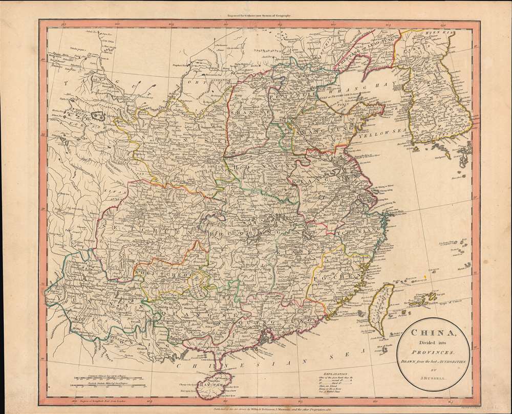

Title
China divided into provinces drawn from the best authorities.
1811 (dated) 15.5 x 17.75 in (39.37 x 45.085 cm) 1 : 6336000
1811 (dated) 15.5 x 17.75 in (39.37 x 45.085 cm) 1 : 6336000
Description
John Russell's scarce map of China, produced for the atlas to the 1811 edition of William Guthrie's A System of Modern Geography. Russell highlights the provinces of 'China proper', or roughly the territory of the Ming Dynasty, conquered by the Qing in the mid-17th century.
As with most European maps of China from this era, Russell draws heavily on Jean-Baptiste Bourguignon d'Anville's map of China, first published about eighty years prior. Anville's cartography is derived from French Jesuits stationed at the Qing Court. Some of these Jesuits had helped conduct a comprehensive land survey for the Chinese emperors in the early 18th century, leading to their maps being much more accurate than earlier European maps of China. However, the drawback of relying on information from a century earlier was the inclusion of anachronisms, such as Huguang (Hou-quang) and Jiangnan (Kiang-nan) provinces, which had been split up by the Qing long before. Anville also focused on 'China Proper,' the territory of the pre 1644 Ming Dynasty, to the exclusion of the equally large but unsurveyed lands in Tibet, Central Asia, Mongolia, and Manchuria that the Qing controlled, conquered, or established suzerainty over.
Russell or his colorist has included Joseon Korea and the Ryukyu Islands as part of the Qing, a common feature of d'Anville inspired maps of China. Although Joseon and the Ryukyus were 'tributaries' of the Qing, they were not under its direct administration as was the case with Chinese provinces. Curiously, Russell has removed d'Anville's note above the Yaeyama Islands about their being under the rule of the Ryukyu Kings (evident here - eastasiasoutheastasia-anville-1752).
At the time this map was made, European interaction with China had diminished from the days when the Jesuits aided in the Qing land survey. Although European traders were active at Canton (Guangzhou), the Rites Controversy and the effective outlawing of Christian missions in China, the Suppression of the Jesuits in Europe, the French Revolution, and the Napoleonic Wars, had cut off the flow of information about China from the Jesuits at the Qing Court. Although the Chinese emperors allowed the Jesuits to remain in Beijing to provide some select services, such as astronomical observations, their numbers diminished, and the last Jesuits at the Qing Court died around the time this map was published. A series of rebellions and domestic challenges at the turn of the 19th century made the Qing even more wary of foreign influence, and information about the Chinese interior was scarce until the 1839 First Opium War.
A Closer Look
Aside from the outlining of provinces, towns and cities, rivers, lakes, mountains, and islands are depicted in detail. The Grand Canal runs through Shandong (Shan-tung) and Kiang-nan (Jiangnan) provinces, towards its terminus at Hangzhou (Hang-tcheoo-fou) and the Yangtze River. Similarly, the Great Wall of China appears to the north and west of Beijing (Pekin).As with most European maps of China from this era, Russell draws heavily on Jean-Baptiste Bourguignon d'Anville's map of China, first published about eighty years prior. Anville's cartography is derived from French Jesuits stationed at the Qing Court. Some of these Jesuits had helped conduct a comprehensive land survey for the Chinese emperors in the early 18th century, leading to their maps being much more accurate than earlier European maps of China. However, the drawback of relying on information from a century earlier was the inclusion of anachronisms, such as Huguang (Hou-quang) and Jiangnan (Kiang-nan) provinces, which had been split up by the Qing long before. Anville also focused on 'China Proper,' the territory of the pre 1644 Ming Dynasty, to the exclusion of the equally large but unsurveyed lands in Tibet, Central Asia, Mongolia, and Manchuria that the Qing controlled, conquered, or established suzerainty over.
Russell or his colorist has included Joseon Korea and the Ryukyu Islands as part of the Qing, a common feature of d'Anville inspired maps of China. Although Joseon and the Ryukyus were 'tributaries' of the Qing, they were not under its direct administration as was the case with Chinese provinces. Curiously, Russell has removed d'Anville's note above the Yaeyama Islands about their being under the rule of the Ryukyu Kings (evident here - eastasiasoutheastasia-anville-1752).
At the time this map was made, European interaction with China had diminished from the days when the Jesuits aided in the Qing land survey. Although European traders were active at Canton (Guangzhou), the Rites Controversy and the effective outlawing of Christian missions in China, the Suppression of the Jesuits in Europe, the French Revolution, and the Napoleonic Wars, had cut off the flow of information about China from the Jesuits at the Qing Court. Although the Chinese emperors allowed the Jesuits to remain in Beijing to provide some select services, such as astronomical observations, their numbers diminished, and the last Jesuits at the Qing Court died around the time this map was published. A series of rebellions and domestic challenges at the turn of the 19th century made the Qing even more wary of foreign influence, and information about the Chinese interior was scarce until the 1839 First Opium War.
Publication History and Census
This map was drawn and engraved by John Russell for the atlas to the 1811 edition of William Guthrie's A System of Modern Geography published by Wilkie and Robinson and J. Mawman. It is independently cataloged among the holdings of the British Library and the National Library of Scotland, while Russell's entire atlas is cataloged among the holdings of six institutions worldwide.CartographerS
John Russell (c. 1750 - 1829) was a British cartographer active in London during the late 18th and early 19th centuries. Russell apprenticed as a goldsmith under William Palmer before turning to engraving and printing. He drew maps and engraved for several major publishers of his period including Alexander Dalrymple, Benjamin Henry, Robert Sayer, John Moore, and William Guthrie. Russell's 10 apprentices included such prominent cartographers as Alexander Findlay and Samuel Clapp. Russell was based on Constitution Row Grays Inn Lane, Middlesex (London). More by this mapmaker...
William Guthrie (1708 - March 9, 1770) was a Scottish historian, journalist, and writer. Born in Brechin, he studied at Aberdeen University with the idea of becoming a parochial schoolmaster. Instead, in 1730, he elected to settle in London and try his hand at literature. He covered parliamentary debates f or the Gentleman's Magazine and soon earned a reputation for being a political writer. He published several scholarly works, including a History of England from the Invasion of Julius Caesar to 1688 in four volumes, and, most notably, his Geographical Historical, and Commercial Grammar. Learn More...
Joseph Mawman (fl. 1797 - 1827) was an English general interest publisher active in London during the early 19th century. Mawman published travel guides and narratives, classical works, natural history books, and literary editions as well as producing contract work for both individuals and institutions. Mawman's offices were established in the Poultry, London where he took over the established publishing firm of Edward and Charles Dilly in 1800. The offices were later relocated to Ludgate Street, also in London. Mawman, who nurtured friendships with various period luminaries, was well known and highly respected intelligence and publishing acumen. Mawman died in 1827. Learn More...
Source
Guthrie, W., A System of Modern Geography (London: Wilkie, Ribonson, Mawman) 1811.
Condition
Good. Even toning. Sporadic spots of discoloration. Some wear at top margin.
References
OCLC 556897680, 316357014.