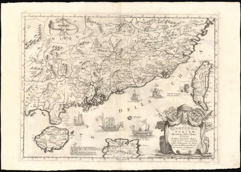
1696 Coronelli Map of Southern China and Taiwan
ChinaTaiwan-coronelli-1696$4,000.00

Title
Quantung, e Fokien, Provincie della China, Dedicate Al Motlo Reverendo Padre Carlo Trigona, dell Compagnia di Gesu, Teologo diu Monsignor Illustriss. Arciuescovo di Palermo, etc.
1696 (undated) 18 x 24 in (45.72 x 60.96 cm) 1 : 3200000
1696 (undated) 18 x 24 in (45.72 x 60.96 cm) 1 : 3200000
Description
This is Vincenzo Coronelli's 1696 map of Guangdong and Fujian, China, including the islands of Hainan and Taiwan, the South China Sea, and part of Luzon in the Philippines. Of Coronelli's maps it is the most focused on the Hong Kong, Pearl River Delta, Macaó region, and among the most detailed depictions of Taiwan of the seventeenth century.
An Array of Sources
For the mainland regions, Coronelli drew primarily on two of Joan Blaeu's maps: Quantung, Imperii Sinarum Provincia Duodecima and Fokien Imperii Sinarum Provincia Undecima. These maps, of Guangdong and Fujian respectively, appeared in the younger Blaeu's atlas presenting the maps of the Jesuit cartographer Martino Martini (1655). Martini's work remained the state of the art for the mapping of mainland China, and Coronelli's embrace of that cartography would remain the best for the late seventeenth century.Luzon Misplaced
Coronelli's presentation of Luzon is puzzling. It appears considerably to the west of its actual location, roughly due south of Taiwan. The source for the placement of the Philippines is unclear, but it is neither Martini nor Blaeu, whose general map of China correctly placed the archipelago. More likely, the misplacement of Luzon is an intentional attempt to illustrate the important trade and diplomatic connections between Macaó, Manila, and Fujian.Formosa / Taiwan
The mapping of Taiwan itself is an astonishing deviation from any known predecessor map. Coronelli is not forthcoming of his source. It is certainly later than any Dutch source contemporary with Blaeu, for in 1661 the Dutch were ejected from Taiwan by Chinese general Zheng Chenggong (Koxinga). The frontispiece of the 1675 Dutch lament to the loss of this island, ''t Verwaerloosde Formosa' is too schematic and lacks sufficient detail to account for the information here. Coronelli did have excellent sources among the Jesuits in the far east, which may account for the detail here. Through them, he may even have had access to copies of Chinese maps.Decorative Engraving
Coronelli's beautifully engraved map is embellished with a martial cartouche, framed with Chinese halberds, bows and arrows, with a fiercely-bewhiskered head - possibly intended to be Koxinga - atop it. The waters within the triangle of Macaó, Luzon, and Taiwan are filled with sailing galleys, alluding again to the rich trade routes of the South China Sea.Publication History and Census
The copperplate for this gore was engraved for use in Coronelli's 1692 Corso geografico universal but was retained for publication in his 1696 Atlante veneto and Isolario. This example's verso text conforms typographically to the latter. Seven examples of the separate map are recorded in OCLC.CartographerS
Vincenzo Maria Coronelli (August 16, 1650 - December 9, 1718) was an important 17th-century cartographer and globe maker based in Venice. Coronelli was born the fifth child of a Venetian tailor. Unlikely to inherit his father's business, he instead apprenticed in Ravenna to a woodcut artist. Around 1663, Coronelli joined the Franciscan Order and, in 1671, entered the Venetian convent of Saint Maria Gloriosa dei Frari. Coronelli excelled in the fields of cosmography, mathematics, and geography. Although his works include the phenomenal Atlante Veneto and Corso Geografico, Coronelli is best known for his globes. In 1678, Coronelli was commissioned to make his first major globes by Ranuccio II Farnese, Duke of Parma. Each superbly engraved globe was five feet in diameter. Louis IV of France, having heard of the magnificent Parma globes, invited Coronelli to Paris, where from 1681-83 he constructed an even more impressive pair of globes measuring over 12 feet in diameter and weighing 2 tons each. The globes earned him the patronage of Louis XIV and privileged access to French cartographic information from Jesuit sources in the New World, particularly Louisiana. Coronelli returned to Venice and continued to publish globes, maps, and atlases, which were admired all over Europe for their beauty, accuracy, and detail. He had a particular fascination for the Great Lakes region, and his early maps of this area were unsurpassed in accuracy for nearly 100 years after their initial publication. He is also well known for his groundbreaking publication of the first accurate map depicting the sources of the Blue Nile. At the height of his career, Coronelli founded the world's first geographical society, the Accademia Cosmografica degli Argonauti, and was awarded the official title Cosmographer of the Republic of Venice. In 1699, in recognition of his extraordinary accomplishment and scholarship, Coronelli was also appointed Father General of the Franciscan Order. The great cartographer and globe maker died in Venice at the age of 68. His extraordinary globes can be seen today at the Bibliothèque Nationale François Mitterrand in Paris, Biblioteca Marciana in Venice, the National Library of Austria, the Globe Museum in Vienna, the Library of Stift Melk, the Special Collections Library of Texas Tech University, as well as lesser works in Trier, Prague, London, and Washington D.C. Coronelli's work is notable for its distinctive style, which is characterized by the high-quality white paper, dark intense impressions, detailed renderings of topographical features in profile, and numerous cartographic innovations. More by this mapmaker...
Joan (Johannes) Blaeu (September 23, 1596 - December 21, 1673) was a Dutch cartographer active in the 17th century. Joan was the son of Willem Janszoon Blaeu, founder of the Blaeu firm. Like his father Willem, Johannes was born in Alkmaar, North Holland. He studied Law, attaining a doctorate, before moving to Amsterdam to join the family mapmaking business. In 1633, Willem arranged for Johannes to take over Hessel Gerritsz's position as the official chartmaker of the Dutch East India Company, although little is known of his work for that organization, which was by contract and oath secretive. What is known is his work supplying the fabulously wealthy VOC with charts was exceedingly profitable. Where other cartographers often fell into financial ruin, the Blaeu firm thrived. It was most likely those profits that allowed the firm to publish the Theatrum Orbis Terrarum, sive, Atlas Novus, their most significant and best-known publication. When Willem Blaeu died in 1638, Johannes, along with his brother Cornelius Blaeu (1616 - 1648) took over the management of the Blaeu firm. In 1662, Joan and Cornelius produced a vastly expanded and updated work, the Atlas Maior, whose handful of editions ranged from 9 to an astonishing 12 volumes. Under the brothers' capable management, the firm continued to prosper until the 1672 Great Amsterdam Fire destroyed their offices and most of their printing plates. Johannes Blaeu, witnessing the destruction of his life's work, died in despondence the following year. He is buried in the Dutch Reformist cemetery of Westerkerk. Johannes Blaeu was survived by his son, also Johannes but commonly called Joan II, who inherited the family's VOC contract, for whom he compiled maps until 1712. Learn More...
Martino Martini (September 20, 1614 - June 6, 1661) was an Italian Jesuit missionary, historian, and cartographer, working mainly on ancient Imperial China. He is acclaimed as the father of Chinese geographical science, as he was ‘the first to study the history and geography of China with rigorous scientific objectivity.' Born in Trento, in the Bishopric of Trent, he finished school in 1631. After, he entered the Society of Jesus and was sent to study classical letters and philosophy at the Roman College, Rome, from 1634 until 1637. He completed his theological studies in Portugal from 1637 until 1639 and was ordained as a priest in Lisbon in 1639. He left for China in 1640, arriving in 1642 in Portuguese Macau. He studied Chinese before, in 1642, moving to Hangzhou, Zhejiang Province. He spent much of his time traveling and gathering scientific information, particularly concerning the geography. In April 1644, soon after his arrival in China, the Ming capital Beijing fell to Li Zicheng’s rebels and then to the Manchus. Martini had been allied with the short-lived regime of Zhu Yujian, Prince of Tang, who declared himself the (Southern) Ming Longwu Emperor after the fall of the last legitimate Ming, the Chongzhen Emperor. When Wenzhou, where Martini was on a mission for Zhu Yujian, was about to fall to the Manchus, Martini convinced them to allow him to change sides. Before the Manchu troops entered the city, Martini created a large red poster stating, 'Here lives a doctor of the divine Law who has come from the Great West.' Below the poster he arranged tables with European books, astronomical instruments, and other objects surrounding an altar with an image of Jesus. The commander of the Manchu troops was so impressed by the display that he politely asked Martini to change sides. In 1651, Martini left China as the Delegate of the Chinese Mission Superior. Among the works he brought with him was Lo Hongxian's (羅洪先; 1504 - 1564) 1555 revision of Zhu Siben's (朱思本;1273 - 1333) 1312 manuscript atlas of the Chinese Provinces, Guang Yu Tu (廣與圖; 'Enlarged Territorial Atlas'). En route, his ship was captured by the Dutch, who apparently also saw Martini's value: they took him first to Java, and then to Amsterdam, where he arrived in 1654. During this intervening period, Martini translated the Zhu Siben atlas into Latin, and added his own description of China. The Blaeu mapmaking firm swiftly published Martini's map as Novus Atlas Sinensis, and later published Martini's description of China both on its own and within the Blaeu Atlas. After his circuitous journey, he reached Rome in the spring of 1655. He carried with him a long and detailed communication from the Jesuit missionaries in China, defending the so-called Chinese Rights (veneration of ancestors and other practices allowed to new Christians). After five months of discussions and debates, the Propaganda Fide issued a degree in favor of the Jesuits, although the controversy did not abate. Learn More...
Source
Coronelli, V., Isolario dell' Atlante Veneto, (Venice: A spese dell' Autore) 1697.
The Isolario dell' Atlante Veneto, also titled Isolario Descrittione Geografico-Historia, is the second part of the Jesuit Minorite friar, geographer, and globe maker Vincenzo Maria Coronelli's multi-volume Atlante Veneto. The Isolario was compiled in Venice and published in 1696-97. The work consists of two parts which, as the title suggests, focus primarily on islands. The first part covers the Mediterranean, Italy, and the Adriatic, while the second part details Britain and Europe, Africa, Japan and Asia, and the West Indies. Like some of his other works, Coronelli published the Isolario 'A spese dell' Autore' [At the Expense of the Author].
Condition
Excellent. Generous margins. Deckled bottom edge.
References
OCLC 224396571. Keating, Jerome F., The Mapping of Taiwan, pp. 64-65.