Digital Image: 1943 Burn Pictorial Map of Sicily Celebrating the Allied Victory
ConquestSicily-burn-1943_d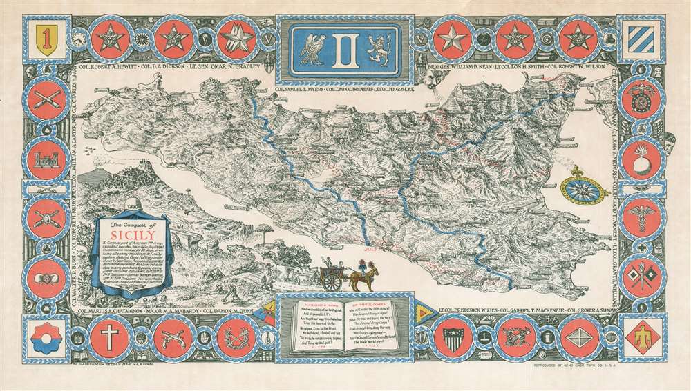

Title
The Conquest of Sicily.
1943 (dated) 11.5 x 20.75 in (29.21 x 52.705 cm)
1943 (dated) 11.5 x 20.75 in (29.21 x 52.705 cm)
Description
FOR THE ORIGINAL ANTIQUE MAP, WITH HISTORICAL ANALYSIS, CLICK HERE.
Digital Map Information
Geographicus maintains an archive of high-resolution rare map scans. We scan our maps at 300 DPI or higher, with newer images being 600 DPI, (either TIFF or JPEG, depending on when the scan was done) which is most cases in suitable for enlargement and printing.
Delivery
Once you purchase our digital scan service, you will receive a download link via email - usually within seconds. Digital orders are delivered as ZIP files, an industry standard file compression protocol that any computer should be able to unpack. Some of our files are very large, and can take some time to download. Most files are saved into your computer's 'Downloads' folder. All delivery is electronic. No physical product is shipped.
Credit and Scope of Use
You can use your digial image any way you want! Our digital images are unrestricted by copyright and can be used, modified, and published freely. The textual description that accompanies the original antique map is not included in the sale of digital images and remains protected by copyright. That said, we put significant care and effort into scanning and editing these maps, and we’d appreciate a credit when possible. Should you wish to credit us, please use the following credit line:
Courtesy of Geographicus Rare Antique Maps (https://www.geographicus.com).
How Large Can I Print?
In general, at 300 DPI, you should at least be able to double the size of the actual image, more so with our 600 DPI images. So, if the original was 10 x 12 inches, you can print at 20 x 24 inches, without quality loss. If your display requirements can accommodate some loss in image quality, you can make it even larger. That being said, no quality of scan will allow you to blow up at 10 x 12 inch map to wall size without significant quality loss. For more information, it is best consult a printer or reprographics specialist.
Refunds
If the high resolution image you ordered is unavailable, we will fully refund your purchase. Otherwise, digital images scans are a service, not a tangible product, and cannot be returned or refunded once the download link is used.
Cartographer
Colonel Walter Pierron Burn (July 17, 1894 - December 4, 1959) was an American advertising agent, artist, cartographer, and military officer. Born in Brooklyn, New York, Burn attending Polytechnic Prepartory School in Brooklynns before serving in the U.S. Army in World War I, attained the rank of major, and fought in five campaigns. He served with Company F, 6th U.S. Engineers, 3rd Infantry Division. After the war, Burn worked as the Pacific Coast Manager, and then the Eastern manager, of the Bureau of Advertising of the American Newspaper Publishers Association. Burn founded his own firm, Walter P. Burn and Associates, in 1936. This company developed special maps and marketing studies for magazines and radio stations. The firm won the National Advertising aware for original research in 1939 fo a series of economic studies for Printers' Ink, the principal business paper of the advertising field. He remained active in the Army Officers' Reserve Corps and was called to active service in 1941. Upon his return to the Army, Burn was appointed chief of training for the newly-formed office of civilian defense. In that position he created the plan, trained the personnel, and produced the directives, texts, handbooks, and films that formed the basis of war activity for several millions of American civilians. After Pearl Harbor, Burn requested a transfer to 'active troop service' and was made the chemical officer of II Corps. Burn landed with II Corps in North Africa, Sicily, and Italy, and was decorated at least three times during World War II. After being wounded at Monte Cassino, Burn was discharged, and he and his family moved to Middlebury, Vermont, where Burn continued his work in advertising and also became the curator of maps at Middlebury College, a position he held until 1957 when he retired due to declining health. Burn married his wife, Marguerite Clement, on September 17, 1917, in New York, with whom he had at least two sons. More by this mapmaker...