1856 Direccion Hidrografia Chart of Cuba, the Bahamas, Haiti, Jamaica
CubaHaitiJamaica-direccionhidrografia-1856$1,200.00


Title
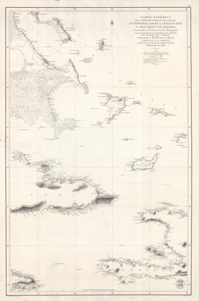
Carta Esferica que comprende parte de las Islas de S.to Domingo, Jamaica, Cuba, Lucayas Y Gran Banco de Bahama.
1856 (dated) 36 x 23.5 in (91.44 x 59.69 cm) 1 : 820000
1856 (dated) 36 x 23.5 in (91.44 x 59.69 cm) 1 : 820000
Description
A highly detailed 1856 nautical chart produced by Spain's Dirección de Hidrografía, taking in portions of the Bahamas, Cuba, Haiti, and Jamaica, and their surrounding waters. It was made as Spain tried to develop naval power to maintain a tenuous hold on its remaining American colonies, Cuba and Santo Domingo.
Soundings, hazards, shoals, anchorages, mountains, coastal features, and other matters of practical interest to mariners are indicated throughout. The 'notas' section under the title provides a key for abbreviations. Hand-drawn annotations track the progress of a ship in March 1867, as well as extend the northern coastline of Cuba into the margin. Longitude is measured from the Real Instituto y Observatorio de la Armada in San Fernando, Cadiz.
Red and yellow coloring note lighthouses, which were built with considerable frequency in the mid-19th century Caribbean. For example, the Punta Maysi (Maisi) Lighthouse (Faro de Punta Maisí) at the easternmost tip of Cuba was only approved in 1856, when the chart was published, and was not operational until 1862. On the southern shore of eastern Cuba, the Faro del Morro at Punta de Cuba, at the entrance of Santiago Bay, was constructed between 1840 and 1842 (it was later damaged in the Spanish-American War).
A Closer Look
Visually, the sheet is roughly divided in two, with the top half dominated by islands and cays of the southern Bahamas, including a string known as the Jumentos Cays or Ragged Island, to the west of which is a vast expanse of shallow water full of rocks, sandbars, and other hazards. Meanwhile, the bottom half takes in the generally deeper waters off eastern Cuba, Haiti, and Jamaica.Soundings, hazards, shoals, anchorages, mountains, coastal features, and other matters of practical interest to mariners are indicated throughout. The 'notas' section under the title provides a key for abbreviations. Hand-drawn annotations track the progress of a ship in March 1867, as well as extend the northern coastline of Cuba into the margin. Longitude is measured from the Real Instituto y Observatorio de la Armada in San Fernando, Cadiz.
Red and yellow coloring note lighthouses, which were built with considerable frequency in the mid-19th century Caribbean. For example, the Punta Maysi (Maisi) Lighthouse (Faro de Punta Maisí) at the easternmost tip of Cuba was only approved in 1856, when the chart was published, and was not operational until 1862. On the southern shore of eastern Cuba, the Faro del Morro at Punta de Cuba, at the entrance of Santiago Bay, was constructed between 1840 and 1842 (it was later damaged in the Spanish-American War).
Publication History and Census
This chart was produced by the Dirección de Hidrografía in 1856, with engraving work done by Francisco Bregante and Pascual Serra. It is listed as presented to Francisco de Lersundi, the Minister of the Navy, who had briefly served as Prime Minister in 1853 and later took on the role of Captain General of Cuba from 1866 to 1869. The chart is quite scarce, only being cataloged with one institution, the University of Wisconsin-Milwaukee, in the OCLC.CartographerS
The Direccion Hidrografía (1787 - 1927), also known as the Deposito Hydrografico and the Direction de Hidrografía, was the Spanish equivalent of the British Admiralty or the U.S. Coast Survey. This organization, founded in 1787, was commissioned to collect and produce accurate nautical charts of all waters frequented by Spanish vessels. In essence, it replaced the Casa de la Contratación de las Indias (House of Trade of the Indies), which closed its doors in 1790. Like most such organizations, the Direccion Hidrografía marked a new age in cartography. Rather than simply collect charts created by navigators, explorers, and merchants, the Direccion Hidrografía worked closely with naval and military personnel to mount cartographic and hydrographic expeditions in pursuit of the most accurate hydrographical, astronomical, and geodetic measurements. The Direccion Hidrografía created a massive library of nautical charts that, though not nearly as common as similar nautical charts by the U.S. Coast Survey and British Admiralty, are highly desirable for the beauty of their manufacture as well as their accuracy and detail. The office was originally located on Calle Ballesta, but relocated to 36 Alcala, both in Madrid. After 1908 the Dirección was subsumed into other governmental agencies. In 1927 the Direccion was absorbed into the Institute and Observatory of San Fernando, located in Cadiz. The library of original maps, charts, and journals was transferred to the Naval Museum of Madrid - where it resides to this day. More by this mapmaker...
Francisco Bregante y Orbay (fl. 1840 - 1867) was a Spanish engraver and draftsman active with the Dirección Hidrografía in the middle part of the 19th century. Bregante y Orbay specialized in lettering and text. A relative, Salvador Bregante y Orbay, also worked for the Dirección Hidrografía in a related capacity. Learn More...
Pascual Serra y Mas (fl. c. 1853 - 1883) was a Spanish line and letter engraver engaged with the Direccion de Hidrografia or Deposito Hidrografico in the second half of the 19th century. Learn More...
Condition
Very good. Sporadic very light foxing. Minor imperfections in the margins.
References
OCLC 979423405.