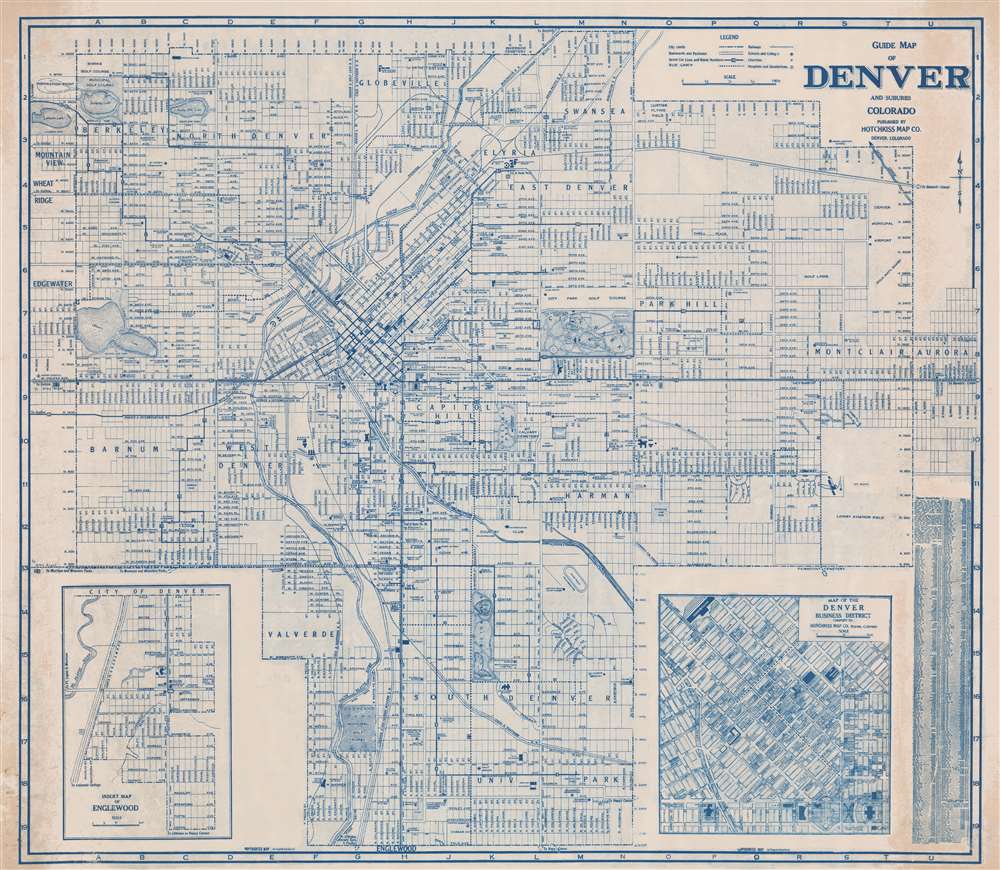
1946 Hotchkiss Wall Map of Denver, Colorado
Denver-hotchkiss-1946$950.00

Title
Guide Map of Denver and Suburbs Colorado.
1946 (undated) 39.75 x 45.75 in (100.965 x 116.205 cm) 1 : 14500
1946 (undated) 39.75 x 45.75 in (100.965 x 116.205 cm) 1 : 14500
Description
This is a striking diazo or whiteprint c. 1946 wall map of Denver, Colorado, by the locally based Hotchkiss Map Company. Centered on Capitol Hill, this map covers all of Denver from Lakeside Lake to Aurora and from 54th Avenue to Englewood. An inset map of Englewood occupies the lower left, while another inset on the lower right details the Denver Business District. The map is highly detailed, showing streets, individual buildings, parks, route numbers, railway lines, churches, schools, and other features. It is extremely large - not to be confused with Hotchkiss' smaller but otherwise similar map appearing in his Denver guide. The diazo medium necessarily limits the number of maps produced - thus underscoring this map's exceptional nature.
Diazo Print or Whiteprint
The diazo print (whiteprint or diazo for short) is a photo reproductive technique best understood as a reverse cyanotype or blueprint. The process yields distinctive blue lines on white paper. Like cyanotypes, the diazo process gained popularity in architecture circles, where it was a simple and effective way to duplicate documents in the field. The earliest diazotypes appeared around 1880 and were adopted for military and field cartographic use from about 1895. The diazo process was commercialized in 1923 when the German firm Kalle and Company developed Ozalid, a patented diazo paper that made diazotyping even easier. By the 1950s, it supplemented cyanotypes as the reprographic technique of choice for technical drawings.Publication History and Census
This map was issued by the Charles J. Hotchkiss map company. It was likely printed in diazo by Delbert W. Smith, the firm's resident whiteprint specialist. Although undated, the presence of the Lowry Aviation Field and the lack of major highways suggest a date of around 1946-7. A smaller version of this map was printed in various Hotchkiss guides, but this wall map version is extremely scarce. We note no other examples on the OCLC but have knowledge of a few others in private hands.Cartographer
Charles Jerome Hotchkiss (December 11, 1887 - November 12, 1950) was a Denver-based map publisher active in the middle part of the 20th century. Hotchkiss was born in Pontiac, Michigan. He served in the Michigan National Guard, achieving the rank of private. We find him in Denver as early as 1909, when he married Esther J. Frinche. By 1910 he was working as a freight insurance auditor for the Colorado and Southern Railroad. He started the Hotchkiss map company in 1933 and, in 1934, advertisements name him 'Successor to Clason Map Co.' At that time, he also continued his practice as a 'freight auditor.' Hotchkiss republished many of Clason's maps, updating and revising them as needed. The business operated at least until his death in 1950. Hotchkiss was also an active Freemason at the 33rd degree. More by this mapmaker...
Condition
Very good. Some toning left and right sides.