Digital Image: 1946 Hotchkiss Wall Map of Denver, Colorado
Denver-hotchkiss-1946_d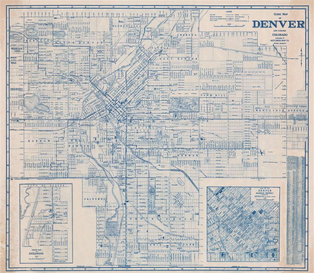

Title
Guide Map of Denver and Suburbs Colorado.
1946 (undated) 39.75 x 45.75 in (100.965 x 116.205 cm) 1 : 14500
1946 (undated) 39.75 x 45.75 in (100.965 x 116.205 cm) 1 : 14500
Description
FOR THE ORIGINAL ANTIQUE MAP, WITH HISTORICAL ANALYSIS, CLICK HERE.
Digital Map Information
Geographicus maintains an archive of high-resolution rare map scans. We scan our maps at 300 DPI or higher, with newer images being 600 DPI, (either TIFF or JPEG, depending on when the scan was done) which is most cases in suitable for enlargement and printing.
Delivery
Once you purchase our digital scan service, you will receive a download link via email - usually within seconds. Digital orders are delivered as ZIP files, an industry standard file compression protocol that any computer should be able to unpack. Some of our files are very large, and can take some time to download. Most files are saved into your computer's 'Downloads' folder. All delivery is electronic. No physical product is shipped.
Credit and Scope of Use
You can use your digial image any way you want! Our digital images are unrestricted by copyright and can be used, modified, and published freely. The textual description that accompanies the original antique map is not included in the sale of digital images and remains protected by copyright. That said, we put significant care and effort into scanning and editing these maps, and we’d appreciate a credit when possible. Should you wish to credit us, please use the following credit line:
Courtesy of Geographicus Rare Antique Maps (https://www.geographicus.com).
How Large Can I Print?
In general, at 300 DPI, you should at least be able to double the size of the actual image, more so with our 600 DPI images. So, if the original was 10 x 12 inches, you can print at 20 x 24 inches, without quality loss. If your display requirements can accommodate some loss in image quality, you can make it even larger. That being said, no quality of scan will allow you to blow up at 10 x 12 inch map to wall size without significant quality loss. For more information, it is best consult a printer or reprographics specialist.
Refunds
If the high resolution image you ordered is unavailable, we will fully refund your purchase. Otherwise, digital images scans are a service, not a tangible product, and cannot be returned or refunded once the download link is used.
Cartographer
Charles Jerome Hotchkiss (December 11, 1887 - November 12, 1950) was a Denver-based map publisher active in the middle part of the 20th century. Hotchkiss was born in Pontiac, Michigan. He served in the Michigan National Guard, achieving the rank of private. We find him in Denver as early as 1909, when he married Esther J. Frinche. By 1910 he was working as a freight insurance auditor for the Colorado and Southern Railroad. He started the Hotchkiss map company in 1933 and, in 1934, advertisements name him 'Successor to Clason Map Co.' At that time, he also continued his practice as a 'freight auditor.' Hotchkiss republished many of Clason's maps, updating and revising them as needed. The business operated at least until his death in 1950. Hotchkiss was also an active Freemason at the 33rd degree. More by this mapmaker...