Digital Image: 1780 Pool and Cash City Map or Plan of Dublin
Dublin-poolcash-1780_d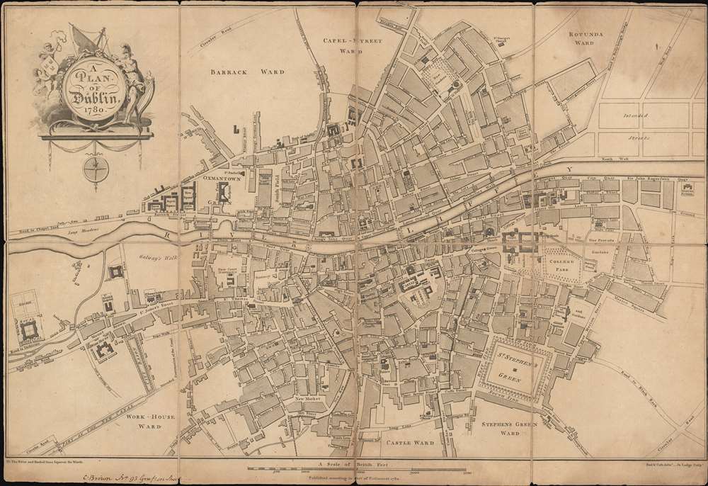

Title
A Plan of Dublin.
1780 (dated) 12.5 x 18 in (31.75 x 45.72 cm) 1 : 6000
1780 (dated) 12.5 x 18 in (31.75 x 45.72 cm) 1 : 6000
Description
FOR THE ORIGINAL ANTIQUE MAP, WITH HISTORICAL ANALYSIS, CLICK HERE.
Digital Map Information
Geographicus maintains an archive of high-resolution rare map scans. We scan our maps at 300 DPI or higher, with newer images being 600 DPI, (either TIFF or JPEG, depending on when the scan was done) which is most cases in suitable for enlargement and printing.
Delivery
Once you purchase our digital scan service, you will receive a download link via email - usually within seconds. Digital orders are delivered as ZIP files, an industry standard file compression protocol that any computer should be able to unpack. Some of our files are very large, and can take some time to download. Most files are saved into your computer's 'Downloads' folder. All delivery is electronic. No physical product is shipped.
Credit and Scope of Use
You can use your digial image any way you want! Our digital images are unrestricted by copyright and can be used, modified, and published freely. The textual description that accompanies the original antique map is not included in the sale of digital images and remains protected by copyright. That said, we put significant care and effort into scanning and editing these maps, and we’d appreciate a credit when possible. Should you wish to credit us, please use the following credit line:
Courtesy of Geographicus Rare Antique Maps (https://www.geographicus.com).
How Large Can I Print?
In general, at 300 DPI, you should at least be able to double the size of the actual image, more so with our 600 DPI images. So, if the original was 10 x 12 inches, you can print at 20 x 24 inches, without quality loss. If your display requirements can accommodate some loss in image quality, you can make it even larger. That being said, no quality of scan will allow you to blow up at 10 x 12 inch map to wall size without significant quality loss. For more information, it is best consult a printer or reprographics specialist.
Refunds
If the high resolution image you ordered is unavailable, we will fully refund your purchase. Otherwise, digital images scans are a service, not a tangible product, and cannot be returned or refunded once the download link is used.
Cartographer S
Robert Pool (17?? - 18??) was an Irish architectural draughtsman who is principally remembered for collaborating on a book entitled Views of the Most Remarkable Public Buildings, Monuments, and Other Edifices in the City of Dublin with fellow architectural draughtsman John Cash. Pool was admitted into the Dublin Society's School of Drawing and Architecture on November 2, 1769 and again on February 22,1770. In 1777, he and Cash submitted the drawings for their celebrated book before the Dublin Society. Pool was designated as an 'architect' in Wilson's Dublin Dictionary, but no buildings designed by him were recorded. Little is known of Pool's private life or, frankly, of his career either. More by this mapmaker...
John Cash (17?? - 18??) was an Irish architectural draughtsman best known for his collaboration with Robert Pool on a book entitled Views of the Most Remarkable Public Buildings, Monuments, and Other Edifices in the City of Dublin. Cash entered the Dublin Society's School of Drawing in Architecture on April 1, 1773 and by 1777 had submitted the drawing for his and Pool's book to the Dublin Society. Little is known about John Cash, but a record exists of a man by that name marrying Isabella Tudor in a church in Dublin on February 19, 1783. Learn More...
John Lodge (1735-1796) was a British engraver, map seller, draughtsman and stationer active in London from roughly 1755 to the late 18th century. Lodge, born in London, was apprenticed to Thomas Jefferys, one of the most prominent and prolific map publishers and engravers of his day. He produced several maps for The Gentleman's Magazine and The Political Magazine and other publications. He also engraved book-illustrations, portraits and botanical plates and taught etching and engraving. Around the 1780's, he is believed to have lived to Dublin, where he did a significant amount of engraving work for Dublin booksellers. Lodge was survived by his wife Ann, to whom he left his entire estate, and his son John Lodge, who was also an engraver. Learn More...
Source
Pool, R. and J. Cash, Views of the Most Remarkable Public Buildings, Monuments, and other Edifices in the City of Dublin, (Dublin: Pool and Cash) 1780.