1581 Ortelius Map of the Duchy of Milan
DuchyMilan-ortelius-1570$450.00

Title
Ducatus Mediolanensis, Finitimarumque Regionū Descriptio,, Auctore Joanne Georgio Septala Mediolanense.
1570 (undated) 14 x 19 in (35.56 x 48.26 cm) 1 : 1300000
1570 (undated) 14 x 19 in (35.56 x 48.26 cm) 1 : 1300000
Description
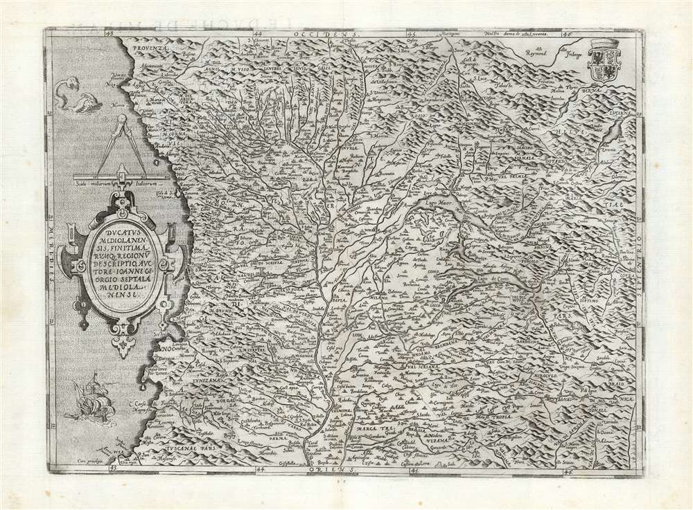
This is Abraham Ortelius' 1570 map of the Duchy of Milan, in Italy. It was based the map of Giovanni Giorgio Settala (1520 - 1590) engraved by Hieronymus Cock, which exists in a sole copy in the British Library. Settala was Milanese, and although most of his life was spent building fortifications for Charles V in Spain, his map was drawn while he lived in Milan.
Spanish authorities had suppressed a map of the Franche-Comté engraved by Hieronymus Cock between 1565 and 1568; if Cock's printing of the Settala map had not been complete prior to the Dutch Revolt and the planning of the Spanish Road it might have suffered the same fate.
The Map
Ortelius closely followed the 1560 original: the most obvious change he instituted was to change the orientation of the map: while the Cock engraving was oriented to the north, Ortelius rotated the map ninety degrees to orient the map to the west, in order to conform to the format of his atlas. The Ligurian sea, plied by a sailing ship and prowled by a sea monster, is visible at the left. The Mediterranean coast is depicted from the French port of Nice in the west to Pisa in the east; Genoa appears near the center of the coast, somewhat overshadowed by the oval strapwork cartouche. The center of the map is dominated by the Po River and its tributaries; along this watershed can be seen Parma, Cremona, Pavia, Milan, and other cities. Approaching the Alps, lakes Maggiore, Lugano, Como, and Iseo can be seen. The right-hand, northernmost extent of the map, details part of Switzerland: Lucerne appears in the upper right, just below the coat of arms of the Duchy of Milan. The alpine regions show a good deal of distortion - for example, Settala's Oglio river (Olio here) is given a course running straight north to south into Lake Iseo, ignoring sharp turns from the east; the extent of the Alps is drastically underestimated, although the pass connecting Lake Maggiore with Lake Lucerne - the Val Premia - is reasonably accurately shown.The 'Spanish Road'
At the time this map was produced, the Duchy of Milan was a fief of Habsburg Spain, and thus part of the Holy Roman Empire; it was the base for Spain's armies in Europe north of the Pyrenees. During the Eighty Years' War, the Spanish army had to be moved from its base in Lombardy to the Netherlands, tasked with suppressing the Dutch Revolt. Sea transport - passing through Gibraltar and up the French coast - was impractical and vulnerable to attack. Thus a land route from Lombardy to the Spanish Netherlands was surveyed: The Spanish Road, which began use in 1567. Spanish troops arriving in Genoa moved through the Duchy of Milan to Savoy in the west, before passing through Franche-Comté, Lorraine and Luxembourg. Spanish forces continued to use the Spanish Road for the next thirty years until the 1601 loss of Savoy to the French.Spanish authorities had suppressed a map of the Franche-Comté engraved by Hieronymus Cock between 1565 and 1568; if Cock's printing of the Settala map had not been complete prior to the Dutch Revolt and the planning of the Spanish Road it might have suffered the same fate.
Publication History and Census
This map was engraved for inclusion in the first edition of Abraham Ortelius' Theatrum Orbis Terrarum and included in all subsequent editions of the work. Van den Broecke cites an unseen 'state zero' of this map bearing the engravers' imprint of the brothers Doetecum, which in all later states has been burnished out with stippling engraved over it: the traces of this can be seen in the lower left corner to the left of the privilege. This example conforms mainly to van den Broecke's to the 125.3 state of the map, but appears to be in transition between that and 125.4; the additional stippling van den Broecke refers to in his description of the latter state appears under the sea monster, but not under the ship. There is evidence of the bow-waves of the ship having been reengraved at some point prior to 1581. The present example agrees typographically with the 1581 French text edition, of which van den Broecke estimates there were 400 printed. Nine examples of that edition are listed in OCLC. In various editions, the separate map is well represented in institutional collections.CartographerS
Abraham Ortelius (April 14, 1527 - June 28, 1598) also known as Ortels, was a cartographer, geographer, and cosmographer of Brabant, active in Antwerp. He was the creator of the first modern atlas, Theatrum Orbis Terrarum and is a seminal figure in the history of cartography. Along with Gerard Mercator and Gemma Frisius, he was a founder of the Netherlandish school of cartography. His connections with Spain - culminating in his 1575 appointment as Royal Cartographer to King Phillip II of Spain - gave him unmatched access to Spanish geographical knowledge during a crucial period of the Age of Discovery. Ortelius was born in 1527 in Antwerp. In 1547 he entered the Antwerp Guild of Saint Luke as an illuminator of maps. He began trading in books, prints, and maps, traveling regularly to the Frankfurt book and print fair, where in 1554 he met Mercator. He accompanied Mercator on journeys throughout France in 1560 and it was at this time, under Mercator's influence, that he appears to have chosen his career as a scientific geographer. His first published geographic work appeared in 1564, an eight-sheet cordiform world map. A handful of other maps preceded the 1570 publication of the first edition of the Theatrum Orbis Terrarum, which would prove to be his life work. Appearing with but 53 maps in its first edition, Ortelius' work expanded with new maps added regularly. By 1592, it had 134 maps. Many of Ortelius' maps remained the standard for nearly a century. He traveled extensively, but his genius was as a compiler, locating the best informed maps on which to base his own. His contacts throughout Europe and extending even (via the Portuguese) to the Far East were formidable. Moreover, many of his maps were based on his own scholarship, particularly his historical works. His theories of geography were particularly ahead of his time with respect to the notion of continental drift, the possibility of which he mused on as early as 1596, and which would be proven correct centuries later.
In a sense his greatest achievement was his successful navigation of the religious and political violence endemic to his city throughout his adult life: The Dutch Revolt, or Eighty Years' War (1568 - 1648), fully embroiled Antwerp. Although outwardly and officially recognized as Catholic (Arias Montanus vouched for Ortelius' Catholic orthodoxy prior to his appointment as Royal Geographer), Ortelius was able to separate himself from the religious furor which characterized the war in the low countries. Ortelius showed a glimpse of himself in a letter to a friend, regarding humanist Justus Lipsius: 'I do not know whether he is an adherent of the Pope or a Calvinist, but if he has ears to hear, he will neither be one nor the other, for sins are committed on both sides'. Ortelius' own explorations of Biblical history in his maps, and the Christogram contained in his own motto, suggest him to be a religious man, but his abjuration of political religious authorities mark him as an individualist. His tombstone at St Michael's Præmonstratensian Abbey in Antwerp bears the inscription, Quietis cultor sine lite, uxore, prole. ('served quietly, without accusation, wife, and offspring.') More by this mapmaker...
Joannes van Doetecum the Elder (1530 - 1605) was a Dutch engraver and cartographer, known for his etchings after Breughel, and an array of maps engraved on his own behalf and that of an array of cartographers. He was born in Deventer, and moved to Haarlem in 1578. He was the start of a dynasty of Dutch map engravers whose work appears on the maps of Gerard De Jode, Abrahanm Ortelius, Jan van Linschoten, Plancius, Plantin, Waghanaer, Jansson, and Visscher. His engraver family included his brother Lucas (fl. 1558 - 1593,) and his sons Johannes II )(fl. 1592-1630) Peter, and Baptista. Despite their prolific work, very little is known about the Doetecum family. Learn More...
Source
Ortelius, A., Theatre de l'univers, contenant les cartes de tout le monde, (Antwerp: Plantin) 1581.
Abraham Ortelius' magnum opus, Theatrum Orbis Terrarum, was the world's first regularly produced atlas, which 'set the standards for later atlases . . . It was the first undertaking of its kind to reduce the best available maps to an uniform format.' (Koeman) A modestly-sized work of fifty-three maps in its first edition of May 1570, it was an immediate success: there were three further editions that year, and the work remained in print for a total of 32 editions, the last of which was 1641, well after its author's 1598 death. Ortelius added to his atlas constantly, and by 1595 the Theatrum contained 147 maps. Ortelius is renowned generally as an editor, and indeed much of the Theatrum is compiled from a variety of sources: in such cases, Ortelius was scrupulous in naming his sources. But Ortelius was also a mapmaker in his own right: many of his maps are a distillation of various sources into his own work, and there were many maps - particularly in his atlas of Biblical and ancient history Parergon - which were entirely Ortelius' work. In his role as an editor, Ortelius followed in the footsteps of Munster, whose Cosmographia was, until Ortelius, the best window on the world for the curious European reader. In terms of the artistry of his maps, Ortelius oversaw the first great flourishing of copperplate engraving in the service of cartography to occur in Northern Europe. Ortelius' work provided the model for the atlases of Mercator, Hondius, Blaeu and all their progeny in the 17th century - many of whom were to produce faithful editions of Ortelius' maps in their own productions.
Condition
Excellent. Two wormholes in margin, else fine with a sharp strike.
References
OCLC 605319054. Rumsey 10000.075. van den Broecke, M., Ortelius Atlas Maps, 125 transition between states 3 and 4.